The Hydrologic Cycle
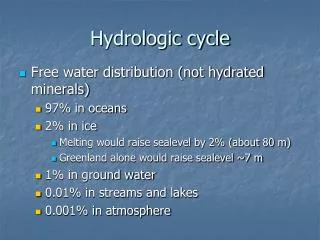
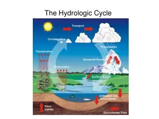
The Hydrologic Cycle. The hydrologic cycle is the movement, exchange, and storage of the Earth's free water. The Hydrologic Cycle. The hydrologic cycle traces the various paths of water from oceans, through the atmosphere, to land, and its return to the oceans. Ground water.


The Hydrologic Cycle
E N D
Presentation Transcript
The Hydrologic Cycle The hydrologic cycle is the movement, exchange, and storage of the Earth's free water.
The Hydrologic Cycle The hydrologic cycle traces the various paths of water from oceans, through the atmosphere, to land, and its return to the oceans.
Ground water Ground water is the part of subsurface water that fully saturates the pore spaces in bedrock, regolith, or soil and so occupies the saturated zone. The water table marks the top of this zone. *See movie on ground water in the geodiscoveries section of your text’s website.
Ground water Water in the soil water belt is available to plants. Water in the unsaturated zone percolates downward to the saturated zone of ground water, where all pores and spaces are filled with water.
Aquifers An aquifer is a layer of sediment or porous rock containing abundant amounts of groundwater. Impervious layers of sediment or rock surrounding aquifers help contain the water - these are known as aquicludes. Aquifers completely surrounded by aquicludes are referred to as confined acquifers while water in unconfined aquifers is free to rise to its natural levels.
Aquifers Aquifers, confined and unconfined.
Karst Landscapes Karst landscapes develop on limestone and related lithologies (such as dolomite) - the carbonate sedimentary rocks. Rock exposed at the surface may be readily weathered to produce an array of small scale features such as a limestone pavement. Rapid weathering in warm climates may lead to tower karst.
Karst Landscapes Solution features in limestone; This outcrop of pure limestone shows grooves and cavities formed by carbonic acid action. County Clare, Ireland.
Karst Landscapes Tower karst: White limestone can be seen exposed in the nearly vertical sides of these towers. Near Guilin, Guanxi Province, southern China.
Chemical Weathering of Limestone The chemical weathering of carbonate rocks encompasses their reaction to acidic water and removal by solution. Water in the environment becomes acidic as carbon dioxide dissolved in water creates a weak carbonic acid. Even marble, the metamorphosed form of limestone shown here, may also be vulnerable. Once limestone reacts with carbonic acid, it is converted to a weaker form that is removed by solution.
Limestone Surface Features Sinkholes are surface features formed from the collapse of a cave or by the solution of surface water. Collapse sinkholes may develop over a number of hours as seen in the lower image.
Limestone Surface Features Sinkholes in limestone are created by solution. These sinkholes are near Roswell, New Mexico.
Limestone Surface Features This sinkhole formed in Winter Park, near Orlando, Florida. The crater appeared at 7:00 p.m., May 8, 1981, and grew to be 100 m wide (330 ft) wide by noon the following day.
Limestone Caverns Groundwater eventually dissolves interior cavities within limestone known as caverns. As overlying rock is also eroded, the ceiling of the cavern may collapse leaving a valley. Eroded carbonate may be deposited on the cavern surfaces as travertine. It can produce a wide variety of forms not only covering the walls but also as stalactites (hanging down from the ceiling like icicles) or stalagtites (protruding from the floor).
Limestone Caverns Evolution of a karst landscape: (a) Rainfall enters the cavern system through sinkholes in the limestone. (b) Extensive collapse of caverns reveals surface streams flowing on shale beds beneath the limestone. Some parts of the flat-floored valley can be cultivated.
Limestone Caverns Inside a cavern: Travertine deposits in the Papoose Room of Carlsbad Cavern in New Mexico.
Surface Water Streams are long, narrow bodies of flowing water that occupy channels, and move to lower levels under the influence of gravity. *See movie on streams in the geodiscoveries section of your text’s website.
Surface Water The velocity of flow is greatest in the middle (a) and at the top (b) of the stream.
The Graded Stream The gradient of a stream channel is the rate of fall in elevation of the stream surface in the downstream direction. When the gradient is steep, the flow velocity will be greater. When the stream channel has a gentle gradient, the velocity will be slower. *See movie on the graded stream in the geodiscoveries section of your text’s website.
The Graded Stream Mean velocity, cross-sectional area, and slope change in the pools and rapids of a stream section of uniform discharge.
Lakes A lake is a water body that has an upper surface exposed to the atmosphere and no appreciable gradient. Lake basins may be created by a number of geological processes such as faulting or by the damming of a river by a lava flow or landslide. However, climate change and sedimentation may also cause lakes to disappear.
Lakes Freshwater pond on Cape Cod.