Download
1 / 27
270 likes | 543 Views
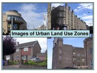
Images of Urban Land Use Zones. Val Vannet 2004. Features of Urban Land Use Zones. The images in this presentation ‘happen’ to be of DUNDEE They show land use along a transect from the CBD to the rural urban fringe Remember that what they show will also be ‘happening’ in a city near YOU!.

E N D
Images of Urban Land Use Zones Val Vannet 2004
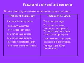
Features of Urban Land Use Zones • The images in this presentation ‘happen’ to be of DUNDEE • They show land use along a transect from the CBD to the rural urban fringe • Remember that what they show will also be ‘happening’ in a city near YOU!
A transect through the city RURAL URBAN FRINGE OUTER CITY INNER CITY CBD
Aerial views Rural urban fringe Outer city Inner city Inner city CBD Inner city
The Central Business District (CBD) civic buildings A mix of old and new shops pedestrian zones
More features of the CBD… offices banks museum and art galleries
The ‘Twilight’ Zone… some features 19th century housing nearby edge of the CBD car parks on ‘cheaper ‘ land vacant land awaiting development
…also called the Zone in Transition • where CBD ‘gives way’ to • inner city • there is a mix of land uses Some redevelopment Inner ring road • land values are cheaper • than in the CBD • marks the limit of the pre- • industrial city bars/restaurants A few shops
The Inner City (1) : Industry In the 19th century more than half of Dundee’s working population worked in the jute industry derelict jute mills The industry declined through the 20th century and there are no jute mills in operation today
The Inner City (2) : Housing 19th century tenements still occupied in 1970 1970! Many derelict and awaiting demolition in 2004 or ……….. 2004
Redevelopment 1960s style inner city factories and houses were demolished and replaced with modern housing High rise in the 1960s but low rise in the late 20th century 1990s style
Other features of the Inner City Victorian parks Main road shopping ‘Refurbished’ tenements
At the edge of the Inner City…… Middle and upper class late Victorian housing These houses were in the suburbs of Dundee in 1900 Today they are well within the city boundary Beyond them lies the outer city of the 20th century
Inner City gives way to Outer City • After WW1 the city began to grow outwards at a faster rate • This was due to developments such as local authority housing, the emergence of building societies and improved public and private transport Inter-war Local Authority housing Inter-war owner occupied housing
The ‘Outer’ Ring Road … 1930! Dundee’s ‘outer’ ring road was built in 1930. Find it on the map. When it was built, it was lined with fields. Since WW2, Dundee has continued to expand well to the north of the outer ring.
Land Use on the Outer Ring Road Why would these land uses locate on the outer ring road ? ‘Beano’ and ‘Dandy’ produced here!
Outer City Housing : Council Estates peripheral housing estates Built by the local authority in the late 20th century often to re-house people from the inner city
Outer City Housing : Private Estates Low density private housing on the edge of the city 1970s 2003 Large houses with modern amenities, spacious gardens and off street parking/garages
Outer City Industry : Industrial Estates Edge-of-city location Easy access Modern, single-storey factories • large areas of • cheap land • room to expand • near to main • roads Landscaped surroundings
The Rural Urban Fringe (1) city gives way to the countryside Agriculture ‘competes’ with a wide range of land uses mainly serving the nearby city…. or does countryside give way to the city? garden centres sports clubs
The Rural Urban Fringe (2) new housing recreation new golf courses!
Which Urban Zone (2)? Outer City Housing Private and Council estates
Which Urban Zone (3)? Inner City Industry
Which Urban Zone (4)? Inner city housing Inner city redevelopment
Which Urban Zone (5)? Outer city industrial estate
Urban Land Use Zones • Almost every city in Britain has a similar range of urban land use zones • Check them out in a city near YOU!