Download
1 / 1
10 likes | 189 Views
Hurricane Ike and Galveston, TX Osmar Padilla – ENVS 4262. Research Statement. Galveston Community Profile & Vulnerability Analysis. Galveston Risk Assessment .

E N D
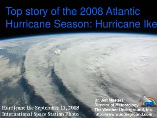
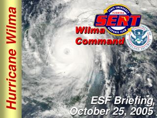
Hurricane Ike and Galveston, TXOsmar Padilla – ENVS 4262 Research Statement Galveston Community Profile & Vulnerability Analysis Galveston Risk Assessment Galveston, Texas is no stranger to hazards. Its location and population lends itself to the possibility of hazards becoming disastrous events. Hurricane Ike in 2008 exposed many vulnerabilities and risks associated with a strong hurricane event. Yet, the storm provides a lens in which to critique mitigation efforts and offer ideas that may lead to better community resiliency. According to the Galveston County hazard mitigation plan, Galveston Island is most at risk for coastal/inland flooding, hurricane wind, and hazardous materials spills. If any of these hazards are to occur, there are over 120 government-designated critical assets in and around Galveston that would be at risk. Depending on the hazard event, infrastructure monetary value at risk starts in the tens of millions of dollars for hurricane wind, but goes up to billions of dollars from potential storm surge. With almost 58,000 permanent residents, ballooning to nearly 100,000 people on the island on any given summer day, Galveston has sizeable population condensed into a very small area. Hurricane Ike: History and Effects Galveston County Critical Assets Galveston Storm Surge Inundation Potential As most hurricanes do, Hurricane Ike began as a cluster of thunderstorms off of the coast of Africa. Within a week, Ike was the most powerful storm of the 2008 season. A Category 4 hurricane packing winds over 145 mph. Just a few days later, the storm would make landfall over Galveston, TX as a strong Category 2 storm with a storm surge equivalent to a Category 5 hurricane (20 ft) Galveston Population Density Of the island’s 58,000 permanent residents, nearly 15% of the population is categorized as “special needs” by the City of Galveston. Coastal & Inland Flooding Hurricane Ike’s path Hurricane Wind Most of the damage from the storm was due to the coastal and inland flooding, as well as from the storm’s winds. The storm surge overtopped the 100-year old Galveston Seawall, and flooded over 75% of all structures on the island. Very High Risk (Costal and Inland Flooding)– High-risk condition with highest priority for mitigation and contingency planning (immediate action). Numerous fatalities & injuries, shutdown of facilities and critical services ≥1 month, property damaged > 50% Moderate Risk (Hurricane Wind) – Risk condition sufficiently high to give consideration for further mitigation and planning (planned action). Multiple severe injuries, shutdown of facilities and critical services ≥ 2 weeks, property damage > 25% In addition, around 30% of the population does not possess a high school degree, with only 20% possessing a college degree. In terms, of Economic Vulnerability, the island depends on its sunny beaches and fun-filled waterparks for a good part of its revenue. As shown above, any disruption to the island’s normal process can have a significant impact on Galveston’s revenue stream. As was the case with Hurricane Ike, the city suffered a massive revenue loss due to lack of tourism, a smaller tax base, and damage to the Port of Galveston. Galveston is also vulnerable environmentally, as coastal erosion and underground oil/gas pipelines are of major concern. According to the United States Geological Survey, Galveston Island is eroding at a rate of around 0.3 square miles per year. In addition, over 7 miles of pipelines crisscross Galveston Bay into Galveston Island. A hazardous event, such as hurricane, can lead to an acceleration of erosion, as well as oil and gas spillage into Galveston Bay and onto the island. Mitigation Critique and Community Resiliency Issues Prior to Hurricane Ike, the only true effort to mitigate potential hazards from a hurricane was to construct the the 17-foot high, 13-mile wide Galveston Seawall following the 1900 Great Hurricane. Following the storm, Galveston made several efforts to mitigate hurricane hazards, including: creating a hazard mitigation plan, drainage improvements, implementing a beach nourishment program to fight erosion, and updating of all building codes. Unfortunately, there are a few issues impacting community resiliency in Galveston. Most importantly is the fact that there is only one way on and off of Galveston Island, the Galveston Causeway. This causes a logistical nightmare to get people on and off the island, as well as to get aid and supplies to stranded residents during an emergency. In addition is the fact that Galveston, due to Dillon’s Rule, has no authority given to it by the State of Texas to enforce building codes. Much research has gone into updating the codes following Hurricane Ike’s devastation, yet residents cannot be forced to comply with them even though the “new” codes may save millions of dollars worth of infrastructure in the future. Flooded residences on the beachfront. Most of the structures in Galveston flooded Hurricane Ike bears down on Galveston Due to Galveston being located on a barrier island, coastal erosion was a major issue following Hurricane Ike. Although the storm brought a 20 foot surge, the vast majority of the erosion occurred as the flood waters receded back into the Gulf of Mexico. Coastal Erosion: Before and After Ike References • http://en.wikipedia.org/wiki/Hurricane_Ike • http://infoaboutike.wordpress.com/ • http://en.wikipedia.org/wiki/Effects_of_Hurricane_Ike_in_Texas • http://www.galveston.com/photoike/ • http://www.hurricanecity.com/city/galveston.htm • http://earthsky.org/water/hurricane-ike-back-surge-eroded-islands • http://conservationreport.com/2008/09/19/atlantic-hurricane-season-hurricane-ike-exposes-a-risky-and-unsustainable-future-for-coastal-communities/ • Galveston Hazard Mitigation Plan - http://www.gcoem.org/content/view/274/145/ • http://coastal.tamug.edu/am/Galveston_Coastal_Erosion_an_overview_of_causes%2C_problems_and_where_we_stand/ • http://coastal.er.usgs.gov/hurricanes/ike/photo-comparisons/galveston.html