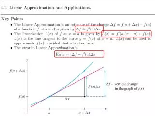
Download
1 / 24
240 likes | 340 Views
Learn how Colorado's Decision Support System utilizes the best scientific methods to estimate consumptive water use, helping water planners overcome limitations in data availability, and enhancing water rights and supply planning. Discover the StateCU model, its data-driven approach, and the development and management of the best data for informed decision-making.

E N D
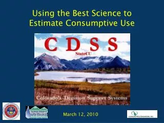
Using the Best Science to Estimate Consumptive Use March 12, 2010
CDSS Goal “Provide the capability to develop credible information on which to base informed decisions concerning water resource management issues.”
How does Colorado’s Decision Support System Help Colorado Water Planners use the Best Science?
Colorado Water Rights and Supply Planning Background • Water right changes require extended period analysis of historical crop CU (~ 50 years) • Planners make decisions based on long-term hydrology and climate data that represents wet, dry, hot, cool periods
Colorado Limitations • Higher elevations and western slope areas do not have climate stations recording daily data required for methods incorporating better science (ex. ASCE Penman) • Daily data required for detailed methods in other areas of the State only available in recent periods • Historical satellite imagery may not be available for Energy-Balance Methods
As a Result: Colorado water right consultants and water planners rely heavily on less data intensive monthly methods, generally Blaney-Criddle Colorado’s Decision Support System helps mitigate limitations of those monthly methods However:
CDSS – Development and Management of “Best Data” • State-wide Irrigated Acreage Assessments • Crop Type • Irrigation Method • Source (Ditch and/or Well) • Goal 5-year Snapshots • GIS and Stored in HydroBase • Water Supply Data • Daily Diversion Records, Pumping Data • Stored in HydroBase
CDSS – Development and Management of “Best Data” • Climate Data “Managed” in HydroBase • NOAA Stations • CoAgMet Stations • Planning-Level Estimates • Specific Conveyance Efficiencies • Maximum Application Efficiencies • Available Water Content • Technical Documents Describing Estimate Procedures and Results
CDSS Data-Centered Approach Consumptive Use ModelStateCU Results for Decision Makers Data Management Interfaces Surface Water ModelStateMod HydroBase (Central Database) Groundwater ModelMODFLOW GIS Coverages
CDSS – Development and Management of “Best Data” • Development/Review of Locally Calibrated Blaney-Criddle Crop Coefficients • Based on Lysimeter Studies, where available • Upper South Platte Basin, Gunnison Basin, Rio Grande • Based on ASCE Penman • Lower South Platte
CDSS – Development and Management of “Best Data” • Coefficient Development Documented, Peer Reviewed, and Stored in HydroBase • Basin-Wide Crop Irrigation Requirements and Supply-limited CU Datasets Available • Yampa River Basin White River Basin • Colorado River Basin Gunnison River Basin • San Juan River Basin Rio Grande Basin • South Platte Basin North Platte River Basin • Basin-Wide Datasets are Structure Based
What is StateCU • The State of Colorado’s Consumptive Use Model • Developed to Estimate and Report Crop Consumptive Use within the State • Publically Available • Enhancements/Additions are Peer Reviewed • Comprehensive Documentation/User Guide
What is StateCU? • StateCU ET Methods include: • Modified and Original Blaney-Criddle (monthly) • Pochop Bluegrass (monthly) • Penman Monteith, ASCE Penman, Modified Hargreaves (daily) • StateCU Effective Precipitation Methods include: • TR-21 SCS Method (monthly) • USBR Method (monthly) • Maximum per Day, Fraction per Day, SCS NEH4 method (daily)
What is StateCU? • Includes Water Supply-Limited Options • Includes River Diversions, Well Pumping, Off-Channel Supplies (reservoirs, tail water) • Considers Conveyance, Application Efficiencies • Performs On-farm Soil Accounting • Includes Water Rights Options • Historical CU senior, junior to specific water right (ex. Upper Gunnison CU subordinated to Aspinall Unit water right) • Historical CU senior, junior to daily call
Why was StateCU Developed? • CDSS Need for a Consumptive Use Analysis Tool • Need for Tool that could be Applied State-wide • Need to Standardize the Approach and Tools Used by CWCB and DWR
How is StateCU Used by Consultants? • Start with Basin-wide Dataset Developed for CDSS • Use CDSS Estimated Acreages, Efficiencies, AWC for initial estimates of Historical CU for Water Right transfers • Refine input files (through StateCU GUI) with site-specific or user-supplied detail • Use StateCU HydroBase Wizard to build CU analysis directly • Acreage, Diversion Records, Climate Data
StateCU Scenario Wizard • The StateCU Scenario Wizard is an interactive tool that guides the user step-by-step through the development of a new monthly scenario and pulls required input data directly from HydroBase through an internet connection. • The StateCU Scenario Wizard can be used to create a new monthly Climate Station Scenario or a Structure Scenario. Required data (e.g. climate data, diversion records, crop characteristics) is pulled directly from HydroBase via an active internet connection and formatted into the correct input files.
StateCU Scenario Wizard Climate stations, and their climate data, that are currently loaded in HydroBase are the only stations available for inclusion in the scenario through the Wizard. The user can either search by the name of the climate station or by the ID.
StateCU Scenario Wizard Several parameters and modeling options are not specifically input by the user into the Wizard, rather it is the responsibility of the user to review and edit these parameters through the GUI.
Contacts Website URL cdss.state.co.us Ray Alvarado – CWCB Water Information Section Chief ray.alvarado@state.co.us 303.866.3441