Download
1 / 54
540 likes | 744 Views
Linking objects of different spatial data sets by integration and Aggregation. An article by Monika Sester, Karl-Heinrich Andres and Volker Walter Lecture by Gil Zellner. What is a map ?. wikipedia :

E N D
Linking objects of different spatial data sets by integration and Aggregation An article by Monika Sester, Karl-Heinrich Andres and Volker Walter Lecture by Gil Zellner
What is a map? wikipedia: Amapis a visual representation of an area—a symbolic depiction highlighting relationships between elements of that space such asobjects, regions, and themes.
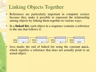
What is a map (cont’d) • A map is not just a 2d image: • List of objects • Partitions of areas • Linking information • Different versions of the same area • Aerial Photo • Satellite Image
Outline • The article discusses ways of integrating different maps onto a single easily accessible database, without losing information.
What is the problem with unification? Satellite images are not always available, often outdated, and more expensive.
What is the problem with unification? (cont’d) • Aerial photo limits • Aerial reconnaissance photos are taken as “strips” of a larger whole. • Even the slightest (and with current technology, unavoidable) shift in angle, connecting them is difficult
What is the problem with unification? (cont’d) • Even if we still had all the data: • Inaccuracies prevent us from matching objects • Terrain is not flat, angle of photography… • Information is not Absolute
Motivation • Many maps today exist in many different formats, each containing : • some correlating information • some different information • The TRUE potential of this information is when it is integrated and we can see all of it at once…
Motivation- examples • Multi-national forces in IRAQ\Afghanistan use non-stanag equipment, which uses arcane map formats, maps are essential for efficient cooperation! - STANAG is a family of NATO standards for military equipment.
Motivation- examples (cont’d) • Information from freely available maps on web sites can be used to see trends in demographics, economy etc…
Motivation- examples (cont’d) What is the closest chinese restaurant ?
Problem • Many formats exist, integrating them can be quite difficult without losing information DLM = digital landscape model Cadastre = bordered maps
Solution? • Conversion into a single format ? Not a viable option, since data can become bloated and hard to decipher, also – some data STILL will be lost!
Solution – take 2 • We keep all the original data, and simply link the objects together, choosing when to use one format or another. • This article focuses on the linking aspects.
Our formats • GDF– specifically designed for road network data – vehicle navigation
Our formats (cont’d) ATKIS– Topographic data system
Our formats (cont’d) Since the common data between system is roads, they are the matching primitives
Matching at object level • The usual system for matching information This is not possible here!
Matching at geometry level • This we CAN do!
How do we efficiently match these objects ? • Cardinality of the matching pairs
Efficient matching (cont’d) Normal Machine vision is clunky and difficult Solution: use noise margins, and Map the matching problem onto a communication system!
Matching function (cont’d) • In order to calculate the mutual information I(D1,D2), • the 2 data sets are seen as messages which consist of symbols represented by our match primitives–the centerlines of streets.
Matching function (cont’d) • For the matching of GDF and ATKIS data we take account the length, shape, and position of start and end points
Matching function (cont’d) • Our final function:
Medium scale object from large scale data through Aggregation • Now that we know how to establish connections between objects of the same scale, we have another problem: • Multi-scale data objects
Multi scale data objects • How do we match objects of different scale ? • First we transform them to a similar scale (data aggregation problem)
Our formats: German ALK (1:500) ATKIS DLM25 (1:25000)
The process • Classification • Based on usage • Relations are check by combination • Aggregation • Adjoining parcels are aggregated • Separated areas are merged accordingly
Learning Aggregation rules • Usage of “typical” machine learning can be used here • What to group • Why group • When to group
Learning Objects and Semantic relations Object Types Classification is derived from the data set Classes created