Download
1 / 13
130 likes | 271 Views
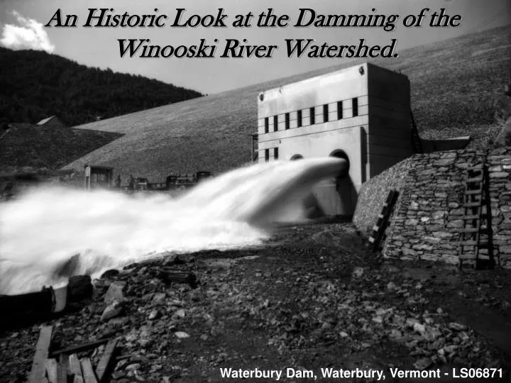
An Historic Look at the Damming of the Winooski River Watershed. The Damming of the Winooski River Watershed. Waterbury Dam, Waterbury, Vermont - LS06871.

E N D
An Historic Look at the Damming of the Winooski River Watershed. The Damming of the Winooski River Watershed. Waterbury Dam, Waterbury, Vermont - LS06871
The Winooski River watershed has been dammed for over 220 years. Today, billions of gallons of water are stored in dam reservoirs, preventing damaging floods and producing hydroelectricity. Agents of tremendous change, dams have forever altered Vermont’s landscape. Continue on to learn about the history behind the damming of the Winooski River watershed. The Winooski River Valley, Burlington, Vermont – LS00691
In 1786, Ira Allen had the first dam constructed on the Winooski River at the Upper Falls, next to the recently settled town of Winooski. Depicted below is the Lower Falls Dam in 1840, just down river of the Upper Falls. LS07742. But why did Ira Allen construct a dam?
The importance of dams cannot be underestimated. Since the late 1700’s, mills run on water-powered machinery produced lumber, iron, food and clothing. Staples upon which young towns were built and relied upon for survival throughout the Winooski River watershed. The Lower Falls Dam on the Winooski River, Winooski, Vermont – LS02284
Vermont’s capital, Montpelier, was built upon the Winooski River. By 1821 the growing town had two dams visible in the picture below. One appears to have been built across the Winooski River, while the other was built across a smaller tributary. A cotton mill in Montpelier had been running off of hydropower since 1810. LS06266.
The next big leap in dam building occurred after the introduction of hydroelectricity in the U.S. in 1881. This location at Bolton Falls on the Winooski River was well-suited for producing hydroelectricity because of the natural drop in the river. Construction began on the timber-crib dam in 1898. The painting in the upper left depicts the reservoir that was created after completion. LS00217. Photo credit of dam building: http://www.electricrailroad.com/Bolton/Bfconst.htm
The Flood of 1927 would spur the next round of dam building on the Winooski River watershed. This photo depicts the Winooski River flowing over the Essex Dam in Essex Junction, at an estimated 116,000 cubic feet per second. Average annual cubic feet per second in 2005 was 1,760! LS11334.
Montpelier was hit hard by the Flood of 1927. Three tributaries joining the Winooski River in Montpelier caused flood waters to exceed ten feet within the city, as shown on the trees in the photo below! It became clear the city would have to protect itself from future floods of such high magnitude. LS06039.
Mill industries along the Winooski River in Winooski, as seen below, were also hit hard by the Flood of 1927. Statewide damage from the hundred-year flood was unprecedented. Flood control dams would be the only means by which towns along the Winooski River could be protected from future floods. LS10427.
In the 1930’s, federal dollars helped build three flood control dams on high risk tributaries of the Winooski River. The Little River’s flood potential was eliminated by the Waterbury Dam, seen below. Built in 1938, at the time it was the largest earth-filled dam east of the Mississippi River! LS06878.
Today, abandoned dams can be seen throughout the Winooski River watershed. Floods and time have washed away all but their footings, allowing flooded land to regenerate. The 1927 aerial photograph on the left depicts the Upper and Lower Falls Dams on the Winooski River in Winooski. In the recent 2004 aerial photo, the Upper Falls Dam has been removed. LS01463. LS01463_001.
Although many have been abandoned, seventeen hydroelectric dams still exist on the Winooski River watershed, producing 43 Megawatts of renewable energy while providing flood control. The Bolton Falls Dam is the Winooski River’s biggest producer at 8.8 Megawatts. Because of their tremendous impact on the land and its waterways, future dam development on the Winooski River watershed is unlikely. Aerial Photo of Winooski River looking towards Burlington, Vermont. LS06743
I Hope You Enjoyed the Story and Images of the Damming of the Winooski River Watershed! PowerPoint Presentation Composed for the Landscape Change Program By Craig Bunten Sources: 1. http://www.electricrailroad.com/Bolton/Bfconst.htm 2. http://www.winooskieagle.com/article.php?story=20050821111222702 3. http://www.essex.org/vertical/Sites/%7B60B9D552-E088-4553-92E3-EA2E9791E5A5%7D/uploads /%7B576EBFC0-FDEC-44FA-93F8-257DA242EC00%7D.PDF 4. http://www.timesargus.com/apps/pbcs.dll/article?AID=/20060731/NEWS/60731001/-1/winooski 5. http://www.montpelier-vt.org/ Waterbury Dam, Waterbury, Vermont – LS06870