Ground Motion Simulations of M=7.5 Earthquake in Marmara Sea: Implications for Istanbul, Turkey
This study focuses on simulating strong ground motion in the Marmara Sea region, specifically for a M=7.5 earthquake scenario, using a multi-asperity source model. Following the 1999 earthquakes, understanding the seismic hazard in Istanbul is critical. We utilize a hybrid modeling approach that combines deterministic and semi-stochastic simulations to evaluate the impact of various parameters on ground motion, particularly for urban resilience planning. The results aim to inform earthquake preparedness strategies and response systems in Istanbul.

Ground Motion Simulations of M=7.5 Earthquake in Marmara Sea: Implications for Istanbul, Turkey
E N D
Presentation Transcript
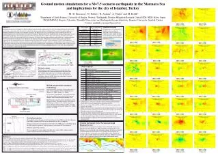
A1 A2 PGA PGV Ground motion simulations for a M=7.5 scenario earthquake in the Marmara Sea and implications for the city of Istanbul, Turkey M. B. Sørensen1, N. Pulido2, K. Atakan1, A. Ojeda3 and M. Erdik4 1Department of Earth Science, University of Bergen, Norway, 2Earthquake Disaster Mitigation Research Center EDM, NIED, Kobe, Japan, 3INGEOMINAS, Bogota, Colombia, 4Kandilli Observatory and Earthquake Research Institute, Bogazici University, Istanbul, Turkey Contact: mathilde.sorensen@geo.uib.no Abstract Following the disastrous earthquakes in Izmit and Düzce along the North Anatolian Fault in 1999, the earthquake hazard in the Istanbul area became a great concern. In this study we simulate the strong-ground motion in the Marmara Sea region with special emphasis in Istanbul. Simulations are based on an earthquake scenario in the Marmara Sea using a multiasperity source model that involves the combined rupture of the North Anatolian fault segments beneath the Marmara Sea. In the simulation of the strong ground motion, we use a hybrid model combining a deterministic simulation of the low frequencies (0.1-1.0 Hz) with a semi-stochastic simulation of the high frequencies (1.0-10.0 Hz) using empirical Green’s functions. We apply a high-frequency radiation model which uses a smooth transition between non-spherical to spherical wave radiation as the frequency increases. Computation at each frequency range is performed separately and the total ground motion is combined in the time domain. We calculate several earthquake scenarios corresponding to different hypocenter locations and source parameters and obtain information on the sensitivity of ground motion to these parameters. This will help us to select the most critical scenario earthquake for the Istanbul region. Computations are performed for both a regular grid and for the recording sites of the recently installed Istanbul Earthquake Early Warning and Rapid Response system. The latter computations can be compared to recorded ground motions. Standard scenario Ground motions are calculated for a standard scenario earthquake. Afterwards, source parameters are varied one by one, and the deviation in ground motion from the standard scenario is plotted to see the effect of individual parameters. Standard scenario source parameters Large earthquakes along NAFZ since 1939 (after Barka et al., 2002)) Other scenarios Tectonic setting The Marmara sea region (NW Turkey) is a tectonically active region situated at the western end of the North Anatolian Fault zone (NAFZ) which splits into several brances in this region. During the last century there has been a westward migration of earthquakes along the NAFZ, and a large earthquake is expected in the Marmara sea in a near future Map of active faulting in the Marmara sea region (after Okay et al., 2000) Hybrid ground motion simulation methodology Hybrid method for simulating ground motions due to a finite-extent earthquake source in the Marmara Sea (Pulido et al., 2004a; Pulido et al., 2004b): Low frequency: Deterministic wave propagation from an asperity model in a flat layered velocity structure (Discrete Wave Number Method, Bouchon, 1981). High Frequency: Semi-Stochastic Simulation based on an asperity model. The model combines the stochastic methodology of Boore (1983) with the empirical Green’s function method of Irikura (1986), and a high frequency radiation pattern model (Pulido et al., 2004a; Pulido et al., 2004b). • Attenuation has a relatively small effect on the ground motion distribution. Largest effect is seen for high frequency attenuation on PGA. • Rise time has a large effect on PGA and PGV in the fault-near regions and a large part of Istanbul. • Rupture velocity also has a large effect on the ground motion levels, especially near the fault and in southern and eastern Istanbul. Noteworthy is the change of PGA up to 0.2g as far east as the Izmit area. • Changing the rupture initiation point changes the directivity effects and therefore affects the distribution of the ground motion. However, most changes are off-shore and the largest effect on land is seen in eastern Istanbul. • The stress drop has a significant effect on ground acceleration in a large area around the fault. General parameters We model the combined rupture of the Central Marmara Fault (CMF) and the North Boundary Fault (NBF) segments of the NAF in the Marmara Sea in a M=7.5 earthquake. The focal mechanism is pure right-lateral strike-slip for the CMF segment and oblique slip for the NBF segment in agreement with fault geometry and regional GPS measurements. Both fault segments dip vertically. We use a regional 1D velocity model (Sarif Baris, pers. comm., 2003), which is used for routine earthquake location in the Marmara sea region. Istanbul Earthquake Early Warning and Rapid Response System Network of 110 accelerometers in Istanbul run by the Kandilli observatory at Bogazici University (Erdik et al., 2003). 10 stations are located close to the Marmara sea coast to provide early earthquake warning. 100 stations are located at critical locations in Istanbul with 2-3 km spacing. When triggering, the stations send data to a main data center which produces shake, damage and casualty maps available within 5 min after the earthquake. Modeled waveforms can be used for calibration, provide realistic input ground motions and be compared to recorded ground motions. References Akinci et al. (in prep.): Ground motion scaling in the Marmara region, Turkey, Manuscript in preparation. Barka et al. (2002): The Surface Rupture and Slip Distribution of the 17 August 1999 Izmit Earthquake (M 7.4), North Anatolian Fault. Bull. Seism. Soc. Am., 92, 43-60. Boore (1983): Stochastic simulation of high frequency ground motions based on seismological models of the radiation spectra, Bull. Seism. Soc. Am., 73, 1865-1894. Bouchon (1981): A simple method to calculate Green’s functions for elastic layered media, Bull. Seism. Soc. Am., 71, 959-971. Erdik et al. (2003): Istanbul Earthquake Rapid Response and the Early Warning Systen, Bulletin of Earthquake Engineering, 1, 157-163. Irikura (1986): Prediction of strong acceleration motion using empirical Green’s function, Proceedings of the 7th Japan. Earthq. Eng. Symp., 151-156. Okay et al. (2000): Active faults and evolving strike-slip basins in the Marmara Sea, northwest Turkey: a multichannel seismic reflection study. Tectonophysics, 321, 189-218. Pulido et al. (2004a): Near-fault strong motion complexity of the 2000 Tottori earthquake (Japan) from a broadband source asperity model, Tectonophysics, 390, 177-192. Pulido et al. (2004b): Strong ground motion estimation in the Sea of Marmara region (Turkey) based on a scenario earthquake, Tectonophysics, 391, 357-374.