Modeling Infrared Images of Earth for Satellite Communication System
10 likes | 113 Views
Develop a MATLAB model to simulate Earth's IR images from space, aiding in testing data compression algorithms. Consider satellite position and orientation for accurate image generation. Improve database for training algorithms. Future enhancements include camera orientation and simulating the sun.

Modeling Infrared Images of Earth for Satellite Communication System
E N D
Presentation Transcript
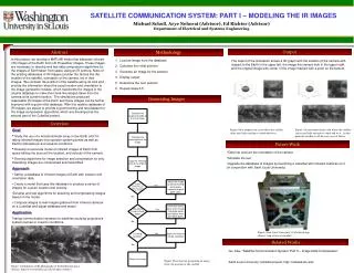
SATELLITE COMMUNICATION SYSTEM: PART I – MODELING THE IR IMAGES Michael Scholl, Arye Nehorai (Advisor), Ed Richter (Advisor) Department of Electrical and Systems Engineering Output Abstract Methodology In this project, we develop a MATLAB model that simulates infrared (IR) images of the Earth from old IR weather images. These images are necessary to develop and test data compression algorithms for the images of Earth taken from space using an IR camera. None of the existing databases of IR images consider the factors like the location of the satellite, orientation of the camera, etc in their images. We consider the position of the satellite along its orbit and provide the information about the exact location and orientation to the image generation module, which transforms the images in the original database to make them look like images taken from the camera at its current location. The simulations produced reasonable IR images of the Earth and these images can be further improved with a good initial database. With this realistic database of IR images, we expect to provide a good training and test dataset for the image compression algorithms, which are developed as the second part of the CubeSat project. Load an image from the database Calculate the initial position Generate an image for the position Display output Determine the next position Repeat steps 3-5 The output of the simulation shows a 3D graph with the location of the camera with respect to the Earth in the upper left, the image the camera took in the upper right, and the original image with center of the image marked with a point on the bottom. Generating Images Overview • Goal • Study the use of a microbolometer array in low Earth orbit for taking infrared images of propulsion system plumes as well as Earth's atmospheric and oceanic conditions. • Develop an accurate model of infrared images of Earth from space taking into account the location, and velocity of the camera. • Develop algorithms for image selection and compression so only interesting images are compressed and transmitted. • Approach • Gather a database of infrared images of Earth with location and orientation data. • Create a model that uses this database to produce a series of images for a given location and velocity. • Develop and test algorithms for selecting and compressing images based on the model. • Compare images to real images gathered from infrared cameras on a CubeSat and adjust database and model. • Application • Testing communication systems for satellites studying propulsions system plumes or oceanic conditions. Figure: First output from a run where the satellite starts near India and moves south and west. Figure: Second output from a run where the satellite starts near India and moves south and west. At this point the satellite is off the east coast of Africa. Future Work • Take into account the orientation of the camera • Simulate the sun • Upgrade the database of images by launching a CubeSat with infrared cameras on it (in conjunction with Saint Louis University) Figure: Saint Louis University’s CubeSat design (Source: http://cubesat.slu.edu/) Related Works Gu, Alex, “Satellite Communication System: Part II – Image Data Compression” Saint Louis University CubeSat project, http://cubesat.slu.edu Figure: Flowchart for generating an image from the position of the satellite Figure: Combination of IR photographs of the Earth from space (Source: http://www.metoffice.gov.uk/weather/satellite/)


