Download
1 / 19
190 likes | 319 Views
Building an Air Quality Community Infrastructure and Connecting with the GEOSS Common Infrastructure. Stefan Falke, Rudolf Husar, Erin Robinson, David McCabe, Frank Lindsay. GEO-VI Air Quality Meeting November 18, 2009. Traditional Project Approach. Do something with the data (add value).

E N D
Building an Air Quality Community Infrastructure and Connecting with the GEOSS Common Infrastructure Stefan Falke, Rudolf Husar, Erin Robinson, David McCabe, Frank Lindsay GEO-VI Air Quality Meeting November 18, 2009
Traditional Project Approach Do something with the data (add value) Generate Product Data Deliver Product to Customer Closed System
Making Project Contributions ReusableSharing/Exchanging with more than the primary customer Deliver Product to Customer Do something with the data (add value) Generate Product Data Provide Website Access (manual) Provide web service access Provide access to processing/analysis/value-adding services
Infusing satellite Data into Environmental Applications (IDEA) A joint NASA-NOAA-EPA initiative: Objective -Prototype a near-real-time MODIS trajectory forecast product using MODIS direct broadcast aerosol optical depth over CONUS. • Goal - Improve accuracy of next day PM2.5 Air Quality Index (AQI) by providing pseudo-synoptic aerosol observations and trajectory forecast during large aerosol events. • Provides forecast guidance for surface air quality (PM2.5) • Dust storms • Smoke from forest fires • Urban/industrial haze • System requirements • Direct broadcast receiving station for satellite data • Trajectory model • Regional meteorological forecast model output • Algorithms to derive aerosol optical depth or related parameters • Surface mass aerosol monitors • System flexibility • Easily adaptable to other regions of the globe • Easy to modify to input other satellite data Benefit - Enable improved mitigation of health effects caused by episodes of poor air quality http://www.star.nesdis.noaa.gov/smcd/spb/aq/ Al-Saadi et. al., September 2005, Bulletin of American Meteorological Society
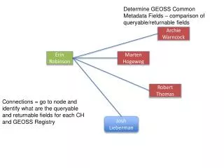
Remote Sensing Information Gateway Atmospheric Chemistry Earth Observations and Models Data Services AQ Data and Image Information Products Satellite: Primary Users NASA MODIS L2 AOD NASA CALIPSO L1b TAB NOAA GOES AOD (GASP) (Future data) NASA CALIPSO L2 Bext , AOD NASA MOPITT L2 CO NASA OMI L2 NO2 NOAA/NASA GOME-2 NO2 • Atmospheric Science Researchers • Air Quality Modelers and Analyst http://www.epa.gov/rsig RSIG System • - Subsetting • Regridding • Comparison • Export in common formats • Fast! Site Obs/Point Data: EPA AIRNow; O3, PM2.5 EPA AQS; O3, PM2.5 EPA UVNet; Irradiance RSIG WCS/WMS Servers Available for Other Systems Secondary Users • Air Quality Regulators and Managers • (RSIG is publicly-accessible.) Modeled: EPA CMAQ Concentrations, Met, Emissions, Deposition EPA Statically Fused Air and Deposition Surfaces O3, PM2.5 NOAA GOES Biomass Burning Emissions; PM2.5, NOx, CO, … Slide provided by J. Syzkman
IEEE Systems Journal, 2008 Design Concept SOA for Data Access & Processing Mediator for 100+ AQ Datasets Includes Tools for Analysis Applied to EPA EE Analysis Supported by NSF, NASA, RPOs, EPA Slide provided by R. Husar http://datafedwiki.wustl.edu/
Giovanni Data Inputs MLS Aura Area Plot Time Series Model Output OMI Aura AIRS Aqua MODIS Aqua MODIS Terra Giovanni Instances SeaWiFS C A B TRMM B HALOE UARS A C E TOMS EP, N7 C F AMSR-E Aqua D MISR Terra F E D CloudSat CALIOP CALIPSO MERRA Models Correlations Column Densities Profile Cross-Section http://disc.sci.gsfc.nasa.gov/giovanni Slide provided by G. Leptoukh
Atmospheric Composition Portal GEO Task AR-09-02b User Contributed Content • Objectives • Provide access, tools, and contextual guidance to scientists and value-adding organizations in using remotely sensed atmospheric composition data, information, and services • Help foster interoperability and application of atmospheric composition data, information and services worldwide • Start with DLR and NASA, work with partners in CEOS and the broader AC community in advancing the AC Portal Users Contextual metadata GEOSS Data Access Gateways Visualization Tools Processing/Analysis Tools Plan is to have a beta version of the ACP by September 2010 OGC WMS DLR DLR DLR OPeNDAP Giovanni Giovanni Giovanni Initial focus on air quality but plan is to server broader community (climate, strat. O3) Datafed Datafed Datafed OGC WCS Others Others Others
Many other AQ related projects… List of US projects from the EPA Data Summit: http://wiki.esipfed.org/index.php/AQ_Data_Systems_and_Processing_Centers Start of an international compilation of project descriptions: http://wiki.esipfed.org/index.php/GEOSS_Relevant_AQ_Projects
A GEOSS Vision for Connecting Air Quality Projects Observing and Modeling Systems
Project A Project A combines multiple data sources to generate near-real time information for the public Project A provides web service interfaces to some of its data and information
Project B Project B analyzes surface and satellite data in support of regulatory analysis and provides web services to their analysis output and analysis tools
Project C Project C provides a web services new data from its work
A new project uses services from projects A, B and C to meet its objectives New Project
GEO Task AR-09-01b: GEOSS Architecture Implementation Pilot (AIP), Phase 2 Connecting communities with the GEOSS Common Infrastructure Main GEO Web Site Registered Community Resources GEOSS Common Infrastructure Client Tier Registries GEO Web Portals Community Portals Client Applications Components & Services Standards and Interoperability Business Process Tier Best Practices Wiki Community Catalogues Workflow Management GEOSS Clearinghouse User Requirements Alert Servers Processing Servers Access Tier GEONETCast Product Access Servers Sensor Web Servers Model Access Servers
Air Quality Community Infrastructure evolving in the GEOSS AIP General search and use of GEOSS data and services GEO Web Portals Users GEOSS Common Infrastructure Air Quality Community Catalog Air Quality Metadata Registry GEOSS Registry GEOSS Clearing-house AQ-specific search and use of GEOSS data and services Metadata Registration Tools AQ Web Applications AQ Databases AQ Web Portals AQ Data Brokers Others Other Search Tools Data Providers
AIP-2 Implementations on the AIP Air Quality Community Infrastructure General search and use of GEOSS data and services 100+ data web service metadata registrations Users GEOSS Common Infrastructure Air Quality Community Catalog AQ-specific search and use of GEOSS data and services AIP-3? DataFed EDAC SEDAC Giovanni NGC ESA Data Providers AIP-2 Workspace: https://sites.google.com/site/geosspilot2/air-quality-and-health-working-group
Example use of the GEOSS Common InfrastructureGraphical user interface to the GEOSS ClearinghouseFiltered for AQ related content uFIND GEOSS Common Infrastructure http://webapps.datafed.net/AQ_uFIND.aspx Search for AQ data GEOSS Registry GEOSS Clearing-house Return AQ metadata filtered AQ metadata available to other applications through RSS, atom, etc.
Ways to participate Community Building • Share your interests and project contributions (like this meeting) • Use ESIP and other air quality communities of practice to advance your project objectives (e.g., ‘built-in’ testers, users…) • Help define the GEOSS GCI and/or Community of Practice Enhance the Information Infrastructure • Become a ‘node’ on the air quality interoperability network • Learn best practices in implementing standards for sharing your project data and tools • Participate in (and shape) the GEOSS Architecture Implementation Pilot • Use the AQ Community Information Architecture (register your services in GEOSS, find information resources useful for your project) • Participate in the development of air quality information networks Collaborate on AQ Science and Research Projects • Define projects that leverage expertise and capabilities across organizations • Document how data, information and capabilities are shared in the project