Download
1 / 21
210 likes | 471 Views
MINISTRY OF NATURAL RESOURCES & ENVIRONMENT REMOTE SENSING CENTRE. Application of LiDAR technology in Vietnam. Dr. Hoang Ngoc Lam MSc. Nguyen Thuc Anh Hanoi, 22 May 2007. Content. Technical details of LiDAR projects Project workflow & examples from current project

E N D
MINISTRY OF NATURAL RESOURCES & ENVIRONMENT REMOTE SENSING CENTRE Application of LiDAR technology in Vietnam Dr. Hoang Ngoc Lam MSc. Nguyen Thuc Anh Hanoi, 22 May 2007
Content • Technical details of LiDAR projects • Project workflow & examples from current project • Applications of LiDAR data • Q & A
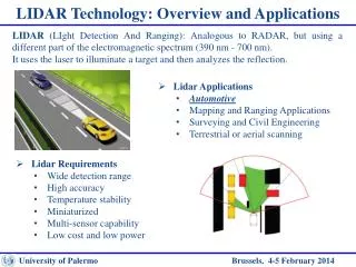
Cantho: 1.800 km2 July 2006 Contractor: AAMHatch LiDAR system: ALTM 3100 C Airplane: ANTONOV 2 Flying speed: 180 km/h Flying altitude: 1500m Strip side-overlap: 25% GPS frequency: 1 Hz INS frequency: 200 Hz Scan frequency: 70 Hz Laser repetition rate: 70kHz Output: Laser points: Clasified Intensity image Quality control: 390 checking points by GPS RTK along roads RMSE: 0.14m Vinhlong - Bentre: 2.200 km2 May 2007 Contractor: GeoKosmos LiDAR system: ALTM 3100 C Airplane: ANTONOV 2 Flying speed: 180 km/h Flying altitude: 1500m Strip side-overlap: 30% GPS frequency: 1 Hz INS frequency: 200 Hz Scan frequency: 70 Hz Laser repetition rate: 70kHz Scale angle: 25 Point density: ~ 1m Digital camera: Rollei AIC modular LS 22Mp Focal length: 50 mm Scale 1:30.000 Ground resolution: 27 cm Output: Laser points: Classified Intensity image Simultaneously taken color air-photo Projects technical details
1053 ground control points by GPS RTK Preliminary results: RMSE = 0.12 m Quality control
Applications • High resolution DEM generation: Integrated GIS for Mekong delta regional development
Applications • 3D city model and urban management applications • DSM generation & Wireless communication management
Other applications • Civil engineering & Infrastructure development • Corridor mapping • Spatial planning • Forestry applications • Flood monitoring • Landslide monitoring • Erosion monitoring • Coastline monitoring • Irrigation management • Coastline analysis and protection • Volumetric studies • Geomorphology & archeology