Enhancing Earth Science Data Accessibility with NASA's World Wind Framework
130 likes | 243 Views
The session by Nadine Alameh, Ph.D., at MobiLaps LLC, highlights NASA's World Wind as an innovative tool to enhance the usability of earth science and planetary data. Key objectives include accommodating the needs of the research community, advancing open-source infrastructure for knowledge exchange, and optimizing data retrieval and visualization. The framework's modular components support various applications, enabling 3D geospatial information representation. Attendees will explore how World Wind facilitates the discovery, integration, and visualization of substantial earth science data, contributing to informed decision-making.

Enhancing Earth Science Data Accessibility with NASA's World Wind Framework
E N D
Presentation Transcript
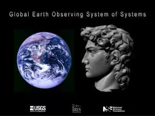
NASA World Wind Contribution to GEOSSClient Applications Session Nadine Alameh, Ph.D. MobiLaps LLC September 26th, 2008
Objectives • Increase usability of growing amount of earth science and planetary data produced by research community. • Accelerate opportunities for research community to provide “advances in fundamental understanding of the Earth system and increased application of this understanding to serve the nation and the people of the world” (NRC Decadal Survey). • Advance Open Source components to support/advance/optimize infrastructure necessary for accelerated innovation and maximum exchange of information.
NASA World Wind Features • 3D geospatial information browser • Suite of modular components to be used selectively or in concert with any number of programs. • API-Centric architecture of SDK • Embeddable as part of any application (window in web page, or extended by application and web developers. • Incorporate virtual globe technology in support of any Earth science objective. • NASA Open Source software • Anyone can advance this technology without being constrained by vendor features/scheduling or proprietary lock-in.
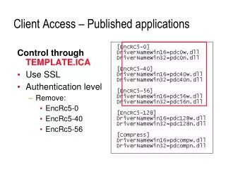
NASA World Wind Features • Terrain generation from real, remote data at high frequency • Image display and selection from terabytes of remote imagery • Rapid management of data retrieval from distributed sources • Getting it all to show up when and where it’s supposed to • In a component as simple to use as a Jbutton • Viewing and picking • Cross-platform and open-source
Icons Text and Annotation Polylines and Polygons Terrain conforming Earth, Planets, Moon Data formats JPEG, PNG, TIFF, RPF,… .bil for elevations GPX, NMEA, CSV for GPS Current Capabilities • 3D World Context • 2-1/2 D World Context • Multiple and user projections • Data retrieval, availability • Geometry Tessellation • Image Application • Picking, Event notification • Viewing and Animation • JavaScript Interface
World Wind’s Proposed Participation • Investigate ways to enhance NASA World Wind with capability of discovering earth science data registered in the GEOSS Clearinghouse and leveraging World Wind’s OGC-standards support in accessing, visualizing and integrating the discovered data in a 3D environment. • Experiment with access to sensor web resources provided as part of the persistent operational services in support of GEOSS SBAs. • Design a set of modules that can become part of the World Wind open source core and can then be used/adapted/extended to support various projects and SBAs.
Expected Benefits • Contributing an open source cross-platform 3D visualization technology. • Supporting SBA scenarios through 3D integration, analysis and visualization of related data. • Leveraging improved discovery, access, integration and visualization of a growing body of earth science data by a variety of users for more effective use of the data. • Great opportunity for the leveraging of open source technology in support of realistic SBA scenarios. • Direct feedback and requirements from the community to help shape the future of World Wind to ensure continued alignment with the GEOSS architecture and maximum value-added for its users.
Applications Multi-Frame Single Frame
Further Information • Code: worldwind.arc.nasa.gov/java • Demos: worldwind.arc.nasa.gov/java/demos • Forums: forum.worldwindcentral.com/forumdisplay.php?f=37 • Bug tracker: issues.worldwind.arc.nasa.gov