Download
1 / 17
170 likes | 305 Views
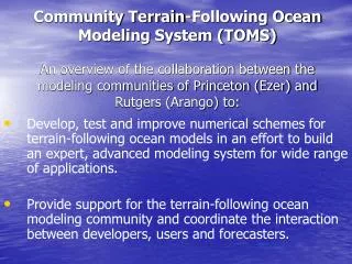
Community Terrain-Following Ocean Modeling System (TOMS) An overview of the collaboration between the modeling communities of Princeton (Ezer) and Rutgers (Arango) to:.

E N D
Community Terrain-Following Ocean Modeling System (TOMS)An overview of the collaboration between the modeling communities of Princeton (Ezer) and Rutgers (Arango) to: Develop, test and improve numerical schemes for terrain-following ocean models in an effort to build an expert, advanced modeling system for wide range of applications. Provide support for the terrain-following ocean modeling community and coordinate the interaction between developers, users and forecasters.
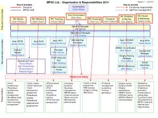
TOMS Executive committee ONR Modeling & Prediction Core model development groups Feedback From testers Feedback From intercomparisons with other models Coordinators TOMS testers Others (HYCOM/MICOM, MOM, POP, MIT…) Princeton (POM, NCOM, ECOM) Rutgers/UCLA (SPEM, SCRUM, SEOM, ROMS/TOMS) Users communities
Workshops • First joint terrain-following ocean models users meeting- Bar Harbor, ME, 9/1999 • motivated the TOMS/ONR initiative & need for collaboration • Second joint terrain-following ocean models users meeting- NCAR, CO, 8/2001 • Inaugural TOMS developers workshop – 8/2001 • Second TOMS developers workshop – 7/2003 • Third joint terrain-following ocean models users meeting- PMEL, Seattle, WA, 8/2003
Web-based support: communication with the terrain-following ocean modeling community • Improve web-based information at both Princeton (http://www.aos.princeton.edu/htdocs.pom/) and Rutgers (http://marine.rutgers.edu/po/) • Launch generic Ocean-Modeling web site (http://www.ocean-modeling.org)
Why is this collaboration useful? • Benefit from several developing groups specializing in different areas (numerics, assimilation, sub grid scale parameterizations, etc.) • New schemes can be tested by many different applications running on different computer architectures (and compared with existing models). • Immediate impact on the ocean modeling community.
A few examples from recent research to evaluate new numerics and parameterizations:… and how users may be affected (e.g., model stability and advanced time stepping schemes)
Sensitivity to internal (DTI) & external (DTE) time steps (Ezer, Arango & Shchepetkin, 2002) ROMS UNSTABLE STABLE TDI/DTE POM CFL=13s
While larger time step is possible in ROMS/TOMS, users should be aware of possible oscillatory behavior for small time step
A recent paper:A possible explanation for ocean model instability occurring for small time stepsB. Heimsund & J. Berntsen, 2003try to explain this numerical instability and suggests a method to evaluate the stability using a simple shallow water equations on a 3-cell grid
Structure ofV (cm/s) in ROMS for different PG schemes (medium seamount case) R-DJ (Vmax=3.7) R-PJQ (Vmax=0.03) R-FPJ (Vmax=30) R-DJC (Vmax=0.06) R-WDJ (Vmax=0.3)
Testing TOMS parallel code (MPI or OpenMP) for different computerarchitectures
The cost of saving output and global averaging is much higher for the MPI code (for the shared-memory SGI machine)
Related research areas (Princeton group) that can contribute to the TOMS development • Parameterization of vertical mixing and modification to the M-Y turbulence scheme: 1. Mixing due to internal waves (Ezer, 2000; Mellor, 2001) 2. Surface mixing due to breaking waves (Mellor, 2003; Mellor & Blumberg, 2003) 3. Bottom mixing and BBL (Ezer & Mellor, 2003) Various turbulent mixing schemes in TOMS (Brunt-Vaisala, M-Y-2.5, KPP, Canuto, Kantha-Clayson) need to be evaluated in view of new research on turbulence mixing.
Generalized coordinate systems (Mellor et al., 2002; Ezer & Mellor, 2003) help to evaluate future hybrid coordinate systems • Estuarine, tides, sediment transport, etc. Experience with POM-related models may help in the development and testing of schemes like wetting-drying. • Pressure gradient schemes Need to sort the many available schemes • Operational forecasting systems Experience in developing such systems with POM at NOAA & Navy labs can help in the transformation of TOMS