Resolution
Resolution. Resolving power Measuring of the ability of a sensor to distinguish between signals that are spatially near or spectrally similar. Spatial Resolution. Measurement of the minimum distance between 2 objects that will allow them to be differentiated from one another in an image.

Resolution
E N D
Presentation Transcript
Resolution • Resolving power • Measuring of the ability of a sensor to distinguish between signals that are spatially near or spectrally similar
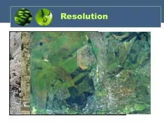
Spatial Resolution Measurement of the minimum distance between 2 objects that will allow them to be differentiated from one another in an image. Function of sensor altitude, detector size, focal size and system configuration • Aerial photographs – resolvable line pairs per millimeter • Satellite sensors – meters, ground area which falls within the IFOVof a single detector within an array (pixel size)
Spatial Resolution • the spatial resolution of the sensor and refers to the size of the smallest possible feature that can be detected • Spatial resolution of passive sensors (we will look at the special case of active microwave sensors later) depends primarily on their Instantaneous Field of View (IFOV)
Instantaneous Field of View (IFOV) • The IFOV is the angular cone of visibility of the sensor (A) and determines the area on the Earth's surface which is "seen" from a given altitude at one particular moment in time (B) • The size of the area viewed is determined by multiplying the IFOV by the distance from the ground to the sensor (C • This area on the ground is called the resolution cell and determines a sensor's maximum spatial resolution
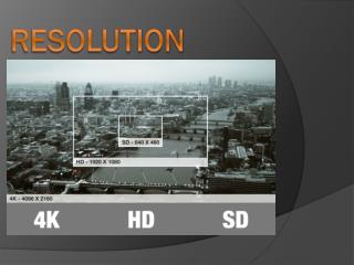
Spatial Resolution Pixel size varies according to the type of sensor recording the data.Pixel size is used to determine resolution quality.Spatial resolution is a measure of the smallest object that can be resolved by the sensor, or the size of the area on the ground represented by each pixel.
Spatial Resolution (contd) If this mock scene were imaged by two different sensors with different spatial resolution, then the sensor with the coarser resolution would display fewer distinguishable features.High resolution imagery provides for better distinguishing of features, but also requires greater data storage capacity for the same amount of area.
Graphic representation showing differences in spatial resolution among some well known sensors (Source: Landsat 7 Science Data Users Handbook) Add SSM/I, GOES Imager, NOAA AVHRR
Spectral Resolution Number and size of the bands which can be recorded by the sensor • Poor – sensitive to large portion of ems contained in a small number of wide bands • Greater – sensitive to same portion of ems but have many small bands Goal– finer spectral sampling to distinguish between scene elements More detailed information about how individual features reflect or emit em energy increase probability of finding unique characteristics that enable it to be distinguished from other features.
Spectral Resolution • Spectral resolution describes the ability of a sensor to define fine wavelength intervals. The finer the spectral resolution, the narrower the wavelength range for a particular channel or band.
Spectral Resolution Each band records a specific portion of the electromagnetic spectrum.Spectral resolution refers to the specific wavelength intervals in the electromagnetic spectrum that a sensor can record.Narrower bands have higher spectral resolution.
Refers to the sensitivity of the sensor to incoming radiance. How much change in radiance must there be a change in recorded brightness value takes place. This sensitivity to different signal levels will determine the total number of values that can be generate by the sensor 26 = (0-63) 64 28 = (0-255) 256 210 = (0-1023) 1024 E.g., GOES Imager – 10bit Landsat 7 ETM+ - 8bit Radiometric Resolution
Radiometric Resolution The radiometric resolution of an imaging system describes its ability to discriminate very slight differences in energy The finer the radiometric resolution of a sensor, the more sensitive it is to detecting small differences in reflected or emitted energy
Temporal Resolution Each satellite has its own unique revisit schedule for obtaining imagery of a particular area. The frequency at which the sensor revisits an area is known as temporal resolution.For example, if a satellite imaged the same area every ten days, then its temporal resolution would be ten days.Temporal resolution is an important factor to consider in change detection studies.
Temporal Resolution Amount of time it takes for a sensor to return to a previously recorded location Examples – GOES NOAA Landsat
Summary of Resolution By increasing 1 or any combination of these resolutions, increase chance of obtaining remotely sensed data about a target that contains accurate, realistic, and useful information. Downside of increased resolution – need for increased storage space, more powerful processing tools, more highly trained individuals.