Download
1 / 1
10 likes | 102 Views
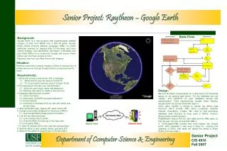
The project aims to setup a secure platform for Raytheon to share imagery on Google Earth from a private server to authorized users. It involves implementing user authentication, database structures, and seamless integration with Google Earth. Technologies used include mySQL, CakePHP, and PHP.

E N D
Department of Computer Science & Engineering Senior Project: Raytheon – Google Earth Background: Google Earth is a free program that superimposes satellite imagery of earth from NASA onto a GIS 3D globe. Google Earth utilizes Keyhole Markup Language (KML) to format additional overlays for tagging Sites Of Interests, add more current imagery, and descriptive information. Individuals can post these KMLs on a community Google web server where others user can have access to them. Raytheon has their own Web Server with imagery. Situation: Raytheon would like to share imagery of sites of interests from a private web server through Google Earth to authorized remote users. Requirements: Setup and access a web server with a database 1.1 Allow users to log into using a remote PC 1.2 PC must install a working copy of Google Earth The web server includes user authentication 2.1 Verify the user's login name and password 2.2 Allowing new users to create a new account. Database data structure includes: 3.1 User’s full name 3.2 Username, and MD5 encrypted password 3.3 Email address 3.4 List Sites of Interests (SOI) by user with public and private flags After successful login, display GE, pass control GE 5. Design a secondary database for structure of KML’s 5.1 Use Google Earth’s data structure for KML’s 6. Link the two data structures. 6.1 Link must by User’s profile. 6.2 Only link KMLs that belong to the login user. 6.3 Link global KMLs If Sites Of Interest (SOI) exist, load into Google Earth Add the ability to add, update, delete, and save SOI 9. Allow for the ability to share Public or Private KMLs Design: We met the basic requirements for a web server by borrowing space on an existing web server. For the database we use mySQL, and CakePHP for user database access and authentication. Then implementing Google Earth Airlines, Google Earth can be launched after sign-in. Once again mySQL is utilized to handle the KML’s data structure, which include: KML name, Longitude, Latitude, Altitude, Description, Creator. We need to add secondary database data structure to keep track of KML’s, location, sharing status (public/private). PhpMyAdmin help to link the User table and the KML table, so that the user can only access their KML’s. If SOI/Imagery/KML existed they were loaded into Google Earth. With CakePHP it was easy to allow for creating and updating of SOI’s. And lastly we tested the ability to share Public or Private KML’s Senior Project CIS 4910 Fall 2007