Download
1 / 1
30 likes | 252 Views
AGRICULTURAL DEVELOPMENT DOMAINS FOR UGANDA: Using GIS and Multi-thematic Datasets to Identify Strategic Agricultural Development Opportunities. Jordan Chamberlin, Stanley Wood, John Pender and Sam Benin † International Food Policy Research Institute. INTRODUCTION

E N D
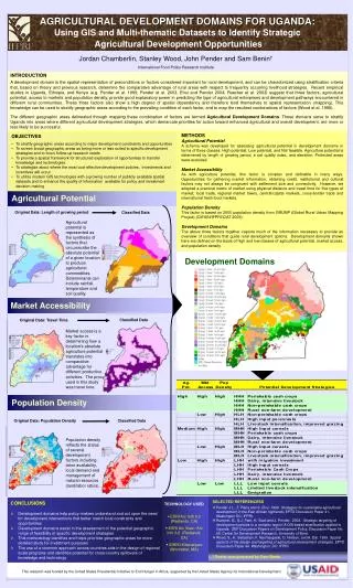
AGRICULTURAL DEVELOPMENT DOMAINS FOR UGANDA: Using GIS and Multi-thematic Datasets to Identify Strategic Agricultural Development Opportunities Jordan Chamberlin, Stanley Wood, John Pender and Sam Benin† International Food Policy Research Institute INTRODUCTION A development domain is the spatial representation of preconditions or factors considered important for rural development, and can be characterized using stratification criteria that, based on theory and previous research, determine the comparative advantage of rural areas with respect to frequently occurring livelihood strategies. Recent empirical studies in Uganda, Ethiopia, and Kenya (e.g. Pender et al. 1999, Pender et al. 2003, Ehui and Pender 2004; Ruecker et al. 2003) suggest that three factors, agricultural potential, access to markets and population density, provide good explanatory power in predicting the type of agricultural enterprises and development pathways encountered in different rural communities. These three factors also show a high degree of spatial dependency and therefore lend themselves to spatial representation (mapping). This knowledge can be used to stratify geographic areas according to the prevailing condition of each factor, and to map the resultant combinations of factors (Wood et al. 1998). The different geographic areas delineated through mapping these combination of factors are termed Agricultural Development Domains. These domains serve to stratify Uganda into areas where different agricultural development strategies, which demarcate priorities for action toward enhanced agricultural and overall development, are more or less likely to be successful. • OBJECTIVES • To stratify geographic areas according to major development constraints and opportunities • To screen broad geographic areas as being more or less suited to specific development strategies and to focus follow-up research needs • To provide a spatial framework for structured exploration of opportunities to transfer knowledge and technologies • To strategize about where the most cost-effective development policies, investments and incentives will occur • To utilize modern GIS technologies with a growing number of publicly available spatial datasets and to enhance the quality of information available for policy and investment decision-making METHODS Agricultural Potential A schema was developed for assessing agricultural potential in development domains in terms of three classes: High potential, Low potential, and Not feasible. Agriculture potential is determined by length of growing period, a soil quality index, and elevation. Protected areas were excluded. Market Accessibility As with agriculture potential, this factor is complex and definable in many ways. Opportunities for gathering market information, obtaining credit, institutional and cultural factors may not always be congruent with settlement size and connectivity. However, we adopted a practical metric of market using physical distance and travel time for five types of market; local trade, regional market towns, central/capital markets, cross-border trade and international fresh food markets. Population Density This factor is based on 2000 population density from GRUMP (Global Rural Urban Mapping Project) (CIESIN/IFPRI/CIAT 2005). Development Domains The above three factors together capture much of the information necessary to provide an overview of conditions that guide rural development options. Development domains shown here are defined on the basis of high and low classes of agricultural potential, market access, and population density. Agricultural Potential Original Data: Length of growing period Classified Data Agricultural potential is represented as the synthesis of factors that circumscribe the absolute potential of a given location to produce agricultural commodities. Determinants can include rainfall, temperature and soil quality. Development Domains Market Accessibility Classified Data Original Data: Travel Time Market access is a key factor in determining how a location’s absolute agriculture potential translates into comparative advantage for different productive activities. The proxy used in this study was travel time. Population Density Original Data: Population Density Classified Data Population density reflects the status of several development factors including: labor availability, local demand and management of natural resources (land/labor ratios). • TECHNOLOGY USED • ESRI Arc GIS 9.0 (Redlands, CA) • ESRI Arc View / Arc Info 3.2 (Redlands, CA) • IDRISI Kilamanjaro (Worcester, MA) • SELECTED REFERENCESS • Pender J.L., F. Place and S. Ehui. 1999. Strategies for sustainable agricultural development in the East African highlands. EPTD Discussion Paper 41. Washington DC: IFPRI. • Ruecker, G., S.J. Park, H. Ssali and J. Pender. 2003. Strategic targeting of development policies to a complex region: A GIS-based stratification applied to Uganda. ZEF Discussion Papers on Development Policy, Discussion Paper No. 69, Center for Development Research, University of Bonn. • Wood, S., K. Sebastian, F. Nachtergaele, D. Nielsen, and A. Dai. 1999. Spatial aspects of the design and targeting of agricultural development strategies. EPTD Discussion Paper 44. Washington, DC: IFPRI CONCLUSIONS • Development domains help policy-makers understand and act upon the need for development interventions that better match local constraints and opportunities • Development domains assist in the assessment of the potential geographic range of feasibility of specific development strategies • This methodology identifies and helps prioritize geographic areas for more detailed study for investment purposes • The use of a common approach across countries aids in the design of regional scale programs and identifies potential for cross-country spillovers of knowledge and technology † Poster was prepared by Sam Benin This research was funded by the United States Presidential Initiative to End Hunger in Africa, supported by the United States Agency for International Development