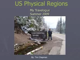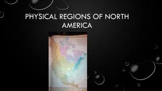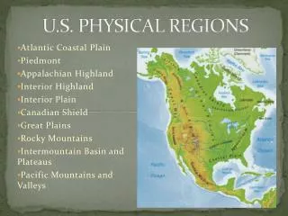
US Physical Regions
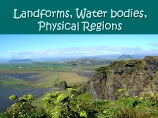
My Travelogue Summer 2009. US Physical Regions. By: Tim Chapman. Introduction. In the summer of 2009, three of my friends and I took a whirlwind, 3-month trek across the US. Included in this travelogue is a map of our journey as well as some photos we took.


US Physical Regions
E N D
Presentation Transcript
My Travelogue Summer 2009 US Physical Regions By: Tim Chapman
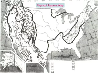
Introduction • In the summer of 2009, three of my friends and I took a whirlwind, 3-month trek across the US. • Included in this travelogue is a map of our journey as well as some photos we took. • We made sure to pass through all eight of America’s main physical regions.
Interior Plains • Our trip began in my hometown of Louisville, Kentucky. • Louisville is in the Heartland section of the Interior Plains. • The vast Interior Plains feature rolling terrain, little rainfall, and few trees. The region is America’s largest, with the highest population and economic output.
Interior Plains • Next we went out onto the Great Plains. • Often called the Great Grass Sea, the Plains feature mile after mile of rolling, treeless land. • Much of the land is used to graze cattle and for growing corn.
Interior Plains • Our trip next took us to the Black Hills. • Called Paha Sapa by the Indians, the land was annexed by the US from the Plains Indians in the 1870’s. • Tourism is very popular in this region. Sites to visit include Mount Rushmore, Deadwood, and the Crazy Horse Monument.
Rocky Mountains • Next we headed west to America’s highest mountain range. • The Rocky Mountains run from Canada to the border with Mexico. Some of the peaks are in excess of 14,000 feet and higher.
Rocky Mountains • We had to stop in Aspen, Colorado where skiing is a big tourist attraction. • One of my friends chose this spot as his favorite, as he is an avid skier. • The tourism industry thrives in the many towns in and around the mountains, where many National Parks can be found.
Rocky Mountains • Our last stop in the Rockies was in northwestern Wyoming at Yellowstone Park. • Yellowstone lies above a vast caldera, or underground volcano. This causes the many thermal features such as Old Faithful. • Many visitors come to see the native wildlife, which includes bison, foxes, and the grizzly bear.
Intermountain Regions Our next stop was in the scenic Intermountain Region. This region lies between the east of the Pacific Coast. It is a region of arid climates and rugged terrain.
Intermountain Regions • Our first stop was in Arizona at the Grand Canyon. • Made exclusively by centuries of erosion, the Grand Canyon has very steep walls with the Colorado River at the bottom. • Nearly five million people see the 1 mile deep Grand Canyon each year.
Intermountain Regions • While visiting my friend’s family in Salt Lake City, our tour of the US made a stop at the Great Salt Lake. • Featuring mile after mile of salt flats, the lake is the largest salt lake in the western hemisphere. • In an average year the lake covers an area of around 1,700 square miles, but the lake's size fluctuates substantially due to its shallowness.
Pacific Coast • Our next stop was in the extremely rugged Pacific Coast. • The Pacific Coast is a 200 mile wide region that stretches from Washington to Southern California. • Many large cities lie in the Pacific Coast, as does our most populous state, California.
Pacific Coast • One stop was in San Francisco, California. • San Francisco lies on an excellent natural harbor called San Francisco Bay. Every day hundreds of ocean-going ships cross the Golden Gate to deliver the world’s goods to the US. • My friend’s favorite stop on our tour was San Francisco. She loves historic sites like the Golden Gate Bridge, Alcatraz Island, and the famous trolley cars of San Francisco.
Pacific Coast • We also made a stop in the northern Pacific Coast. • Much of the region is heavily forested, which makes for a healthy logging industry. • Other sites worth seeing are Mt. Saint Helens and Crater Lake, the deepest lake in the United States.
Canadian Shield • Situated near the Great Lakes, the Canadian Shield was our next stop. • The shield is a relatively small and very cold region. It is mostly forested, with little to no soil and thousands of glacial lakes.
Canadian Shield • Our first stop in the Canadian Shield was Duluth, Minnesota. • Duluth has a healthy international trade industry due to the St. Lawrence Seaway. • The seaway allows businesses along the Great Lakes to send goods via ships to the cities of the world.
Canadian Shield • Our final site in the Canadian Shield was Lake Huron. • Part of the Great Lakes, Lake Huron is named for the Native Americans the French discovered living in it’s vicinity. • Fishing for lake trout on Lake Huron was a highlight of our trip.
Appalachian Mountains Our next stop was in the Appalachian Mountains, located in the eastern half of the country. Much lower and older than the Rockies, they extend from Vermont in the North to Alabama in the South. They also include the Ozarks in Arkansas and Missouri.
Appalachian Mountains • A hiking trip was up next, so we stopped at the Appalachian Trail. • The Appalachian Trail is a hiking trail in the eastern United States, extending between Springer Mountain in Georgia and Mount Katahdin in Maine. It is approximately 2,175 miles long.
Appalachian Mountains • Our next stop in the mountains was in eastern Kentucky at the Blue Heron Coal Mine. • There are also large underground deposits of coal in sections of Pennsylvania and West Virginia. • Coal is mostly used to generate electricity, but it also used to make steel.
Atlantic Coastal Plain • Our second to last stop in my travelogue is the Atlantic Coastal Plain. • Comprising the entire eastern coast of the US, the Atlantic Coastal stretches from Maine to Texas, is heavily populated, and mostly flat. • The ACP is actually three large regions: New England, the Piedmont or Middle Atlantic, and the subtropical Gulf Coast.
Atlantic Coastal Plain • My best friend loves a crowd, so his favorite part of the trip was New York City. • Part of a huge sprawling urban megalopolis, New York is America’s largest city and the financial heart of North America. • There are many site to see in New York, including the stock exchange, the Statue of Liberty, and the 843 acre Central Park in Manhattan.
Atlantic Coastal Plain • Our final stop in the continental US was at Daytona Beach in Florida. • The city is historically known as having one of the few beaches in the world where the hard packed sand allows motorized vehicles to drive on the beach in restricted areas. This hard packed sand made Daytona Beach a mecca for motorsports, with the old Daytona Beach Road Course having hosted races for over 50 years. • Many residents of Florida make their living in the tourist industry.
The Hawaiian Islands • My favorite stop on our long trip across the US was our last one, in Hawaii. • The Hawaiian Islands are eight large islands and numerous smaller ones that lie in the Pacific Ocean and were made entirely by volcanoes.
The Hawaiian Islands • Part of our trip to Hawaii included a hike up Mauna Loa, one of two massive volcanoes on the main island of Hawaii. • Mauna Loa is the largest volcano on Earth in terms of area covered and one of five volcanoes that form the Island of Hawaii. It is an active shield volcano, with a volume estimated at approximately 18,000 cubic miles.
The Hawaiian Islands • Our last stop was at Waikiki on the island of Oahu. • Located near Honolulu, the capital of Hawaii, Waikīkī Beach is noted for its views of the Diamond Head tuff cone, its usually warm and cloud-free climate and its surf break.
Conclusion • Our trip across America taught us a great deal about our country, it’s geography, and the people who live there. • I learned that the physical and human characteristics are as varied as any place on Earth. • From the broad, flat coastal plains near the Atlantic and Gulf shores to the Texas-Mexico border, and from New York City to the tropical beaches of Hawaii people have adapted their lives to fit the land nature provides.