Download
1 / 18
180 likes | 333 Views
Effects of Climate Change on Natural and Regulated Flood Risks in the Skagit River Basin and Prospects for Adaptation. Se-Yeun Lee 1 Alan F. Hamlet 2,1. Dept. of Civil and Env . Engineering, UW CSES Climate Impacts Group, UW. Study Area : The Skagit River Basin.

E N D
Effects of Climate Change on Natural and Regulated Flood Risks in the Skagit River Basin and Prospects for Adaptation Se-Yeun Lee1 Alan F. Hamlet2,1 • Dept. of Civil and Env. Engineering, UW • CSES Climate Impacts Group, UW
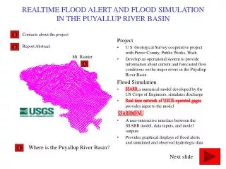
Study Area : The Skagit River Basin • Ross dam on the Upper Skagit River and Upper Baker dam on the Baker River have storages for flood control. • Inflows to Ross and Upper Baker dams are relatively small portion (less than 40 %) of the total flows in the lower Skagit River.
Town of Hamilton during October 2003 Flood • In the 20th century, the town of Hamilton has flooded more than 17 times. • The town of Hamilton now floods every three years or so.
Recent Research • Climate change is likely to substantially increase flood risks in the Skagit River Basin under natural or unregulated flows (Tohverand Hamlet, 2010; Hamlet et al. 2010). • In order to increase flood protection in the flood plain, Skagit County proposed (or is considering) modifications of current flood control operations (Steward and Associates, 2005; Skagit County, 2008). Are current and/or proposed flood control operations adequate for managing the projected 100 year flood risk in the Skagit River Basin?
VIC Hydrologic Model (Variable Infiltration Capacity Hydrologic Model) • Solve the water and energy balance at each model grid cell • Produce runoff and baseflow at each model grid cell for each model timestep • Generate Streamflow for historical run and for the 2040s and the 2080s for Echam 5 A1B* * Echam 5 A1B is a global climate model scenario which approximates the average conditions simulated by all models
The Skagit River Simulation Model Ross Upper Baker Diablo Gorge Lower Baker Upper Skagit River Baker River Concrete Mount Vernon Sauk River : Storage • Evaluate Current and Proposed Flood Control Operations • Include Flood control, Hydropower, Instream Flow : Run of River
Flood Control Curves 60kcfs-days 90kcfs-days 37kcfs-days 75kcfs-days
Changes in Flood Risks under Natural Conditions • Timing shifts of peak flows from spring to winter • Increases in magnitude of peak flows
100-year Flood Statistics at the Skagit River near Mount Vernon Baseline Condition 20 % 24 % The alternative flood control operations are largely ineffective in mitigating the increased flood risks.
Contribution of Ross, Upper Baker and Others to Mount Vernon for the Top 5 Flood Years
Conclusion • A warmer climate is likely to shift the seasonal timing of peak flows in the Skagit River from spring to fall/winter and increase the risk of flooding. • Current and/or proposed flood control operations are projected not to be effective at mitigating these increased flood risks. • Current and/or proposed flood storages on headwaters mitigate the impacts of natural floods only for the headwaters during high flow events, which is relatively small portion of the total flow in the lower Skagit River Basin.
Conclusion (Cont’d) • Climate change adaptation efforts will need to focus primarily on improved management of the floodplain to reduce vulnerability to increasing flood risk. • These results using a single Global Climate Model (GCM )scenario will need to be extended to include more GCM scenarios or Regional Climate Model scenarios which provide explicit and more realistic simulations of storms in the Skagit Basin.
Reference • Hamlet, A.F., Lee, S.Y., Mantua, N.J., Salathe, E.P., Snover, A.K., Steed, R., and Tohver, I., 2010. Seattle City Light climate change analysis for the city of Seattle, Seattle City Light Department, The Climate Impacts Group, Center for Science in the Earth System, Joint Institute or the Study of the Atmosphere and Ocean, University of Washington, Seattle, Washington. http://cses.washington.edu/db/pdf/snoveretalscl709.pdf. • Skagit County, 2007. The Skagit River flood risk: Will you be prepared when disaster strikes? Flood Awareness Week, October 7-13, 2007, Washington. • Steward and Associates, 2004. Environmental effects of additional flood control on the Baker river. Snohomish, Washington. http://www.skagitriverhistory.com/Skagit%20County%20Docs/Flood_Control_Impacts_Report_08%2011%2004.pdf • Tohver, I.M., and Hamlet, A.F., 2010. Impacts of 21st century climate change on hydrologic extremes in the Pacific Northwest region of North America. The Columbia Basin Climate Change Scenarios Project (CBCCSP), chapter 7. http://www.hydro.washington.edu/2860/report/
Projected Flood Risks for the Skagit River near Mount Vernon
Changes in Flood Risks under Regulated Conditions • Timing shifts of peak flows from spring to winter • Increases in magnitude of peak flows