Download
1 / 43
460 likes | 729 Views
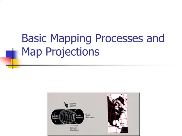
Mapping and Projections. Web resources: Geographer’s Craft, Department of Geography, University of Colorado at Boulder - particularly Peter H. Dana’s part http://www.colorado.edu/geography/gcraft/contents.html

E N D
Mapping and Projections Web resources: Geographer’s Craft, Department of Geography, University of Colorado at Boulder - particularly Peter H. Dana’s part http://www.colorado.edu/geography/gcraft/contents.html Laurie Garo, Map Projections module, in Virtual Geography Department, U. of Texas at Austin (hosted at U. of Colorado) http://www.colorado.edu/geography/virtdept/contents.html
Map Projections • Basic problem: • Earth is round • Paper is flat
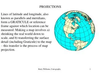
Solving the Problem • How do you represent a curved surface on a flat surface? • Bonehead way - just plot latitude vs. longitude as cartesian rectangular coordinates • Projection - fit a flat surface around (or through) a sphere, and trace the pertinent information on it
Types of projections • Three main families: • Cylindrical - wrap sheet of paper around globe in cylinder shape • Also pseudocylindrical - like cylindrical but the sheet of paper bends inward at the poles • Conic - form sheet of paper into a cone and insert globe • Also polyconic - multiple cones • Azimuthal - place flat sheet of paper next to globe; project features out onto it
Cylindrical Projection • Formed by wrapping a large, flat plane around the globe to form a cylinder. • Transfer latitude, longitude, shapes onto cylinder, then unfolded into a flat plane. • Typically used to represent the entire world; often projected from center of globe with equator as tangent line • Most types show parallels and meridians forming straight perpendicular lines.
Pseudocylindrical Projection • Projection surface is not rectangular • Instead, it curves inwards at the poles. • Latitude lines are straight; central meridian is straight, but other meridians are curved (concave toward the central meridian). • Often used for world maps
Conic Projection • Points from the globe are transferred to a cone fit around the sphere. • Usually, the pointy end of the cone is directly over the north or south pole, but you can do it anywhere. • Can represent both hemispheres, but distortion increases the farther along the cone you go
Conic Projection • Often used to project areas that have a greater east-west extent than north-south, e.g., the United States. • When projected from the center of the globe, conic projections typically show parallels forming arcs concave toward the North or South pole, and meridians are either straight or curved and radiate outwards from the direction of the point of the cone.
Polyconic Projection • Complex projection, used originally by USGS for quadrangle maps of U.S. • Uses an infinite number of cones applied to an infinite number of tangents across a given hemisphere • Reduces distortion, but harder to conceptualize and produce
Azimuthal or Planar Projection • Globe grid is projected onto a flat plane • Plane is normally placed above the north or south pole, so normally only one hemisphere, or a portion of it, is represented • When projected from the center of the globe, a typical polar azimuthal projection shows circular latitude lines with radiating longitude lines
Oblique Azimuthal Projection Orthographic sort of means viewed from infinite distance
Types of projections • Tangent • Flat surface only touches globe along one circular line (or at one point for Azimuthal) • Secant • Flat surface passes through globe; touches surface at two circular lines (or in one circle for Azimuthal) • Some projection is inward rather than outward • Reduces distortion of large areas
Tissot indicators • Tissot’s idea - to see the effects of distortion, show what shape small circles on the surface of the globe take after projection • This shows shape, scale, area, and other distortions
Tissot Indicators – Mercator (Conformal) Image from http://quantdec.com/tissot
Tissot Indicators – Peters Equal Area Image from http://quantdec.com/tissot
Tissot Indicators – Azimuthal Equidistant Image from http://quantdec.com/tissot
Web sites to visit: • http://www.guilford.edu/geology/Geo340.html