Download
1 / 22
220 likes | 371 Views
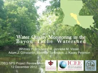
Whitney P. Broussard III, Jenneke M. Visser, Adam J. Constantin, Matthew Tarkington, J. Kacey Peterson. Water Quality Monitoring in the Bayou Teche Watershed. LDEQ NPS Project Review Meeting 12 December 2012. Background - Rationale.

E N D
Whitney P. Broussard III, Jenneke M. Visser, Adam J. Constantin, Matthew Tarkington, J. Kacey Peterson Water Quality Monitoring in the Bayou Teche Watershed LDEQ NPS Project Review Meeting 12 December 2012
Background - Rationale • Cropland (rice and sugarcane), pasture, woodlands, wetlands, urban – “Rural” watershed • Several WWTP. Rural residential septic systems on the mainstem. • Suspected causes of impairment include oxygen demand, BOD substances, DO, nutrients, sewage. • TMDLs have been completed for 9 subsegments. • Comprehensive water quality only at Adeline, LA. Historical records at Breaux Bridge. • Detailed water quality information for the remainder of the watershed is largely unavailable.
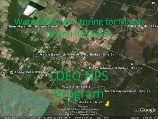
Project Objectives • Monthly monitoring for 12 calendar months • Record and deliver in situ field parameters • DO, turbidity, pH, electrical conductivity, and temperature • Record and deliver laboratory parameters • Nitrate, Nitrite, Phosphate, Sulfate, BOD5, TP, TS, TSS, and fecal coliform concentrations • Watershed scale monitoring – 15 located a junctures with tributaries and distributaries • Identify ‘hot spots’ by subsegments • Determine land management practices associated with hot-spot subsegments • The following questions will be addressed in the course of the project: Is there a significant difference between the concentration of NPS pollutants in the diverted Atchafalaya River water and Bayou Teche water at Charenton Canal? If so, which subsegment of the project watershed is significantly contributing to the NPS pollutant load?
Methods Notes • 15 monitoring locations are distributed along Bayou Teche from the headwaters to the mouth. • This approach, complimented by the use of a boat for sample collection, allows for the experimental design and monitoring locations to be determined by the watershed drainage network. • YSI – DO, Turbidity, pH, Cond. Temp • Callegari Laboratory – NO3, NO2, PO4, TP, SO4, BOD5, TS, TSS, fecal coliform • Geospatial techniques used to delineate station sub-basins and analyze land cover by sub-basin
Progress to Date • Team – 1 Research Scientist, 1 Assoc. Prof., 2 Research Associates and 1 Undergraduate Student • Purchased 2 YSI multi-parameter water quality sondes • Set up field support laboratory and outfitted with proper field and laboratory safety equipment • Completed QAPP • Collected WQ data Jan-Nov • Delineated sub-basins for each station • Quantified land cover and NDVI data by sub-basin • Completed map-book of land cover and WQ data for public consumption • Spatially explicit regression analyses correlating land use and water quality parameters are ongoing • Final report, data, and results will be completed on time at project end – Jan 2013
3% 2% 2% 3% 5% 8% 35% 11% 30%