Download
1 / 1
30 likes | 175 Views
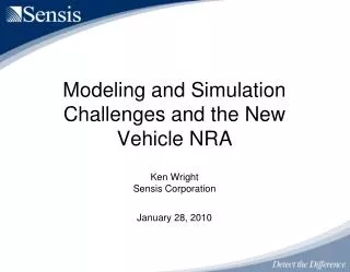
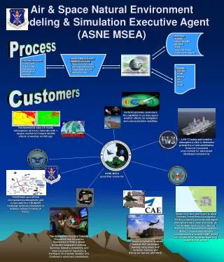
Air & Space Natural Environment Modeling & Simulation Executive Agent (ASNE MSEA). Databases ACMES NCEP/NCARS MODAS WW3 Space Archives Previous Products. Process. Customer Request Conditions Place/Time Parameters Resolution Format. Subject Matter Expert (SME) Processing

E N D
Air & Space Natural Environment Modeling & Simulation Executive Agent(ASNE MSEA) • Databases • ACMES • NCEP/NCARS • MODAS • WW3 • Space Archives • Previous Products Process • Customer Request • Conditions • Place/Time • Parameters • Resolution • Format • Subject Matter Expert • (SME) Processing • Search for Scenario • Identify Data Source • Verify Data Output • Check Format • Formats • SEDRIS • GRIB • Binary • CSV • PRF • Other Customers IonScint provides customers the capability to portray space weather effects on navigation and communication satellites. Environmental data (18-month atmospheric at 6-hour intervals with 1-degree resolution) helped identify effects of weather on ISR ops. LPD-17 using authoritative atmospheric data to determine probability of raid annihilation. Ensured consistent environment for dislocated/ distributed simulations. ASNE MSEA generates scenarios OSD(PA&E) and AFSAA incorporating atmospheric and ocean data into THUNDER campaign analysis simulation to analyze various Courses of Action. Unique interface developed to allow Defense Threat Reduction Agency (DTRA) to rapidly generate and ingest atmospheric data from worldwide 40-km ACMES database into Hazard Prediction and Assessment Capability (HPAC). Used to help mitigate consequences of possible NBC event in OIF and other incidents regarding dispersion of toxins. The Interservice/Industry Training Simulation and Education Conference (I/ITSEC), which promotes cooperation among Services, Industry, Academia, and other Government Agencies is starting to incorporate weather into Conference exercises/simulations. Hi-resolution weather enables realistic SOF helicopter training using Army SOF Aviation Training and Rehearsal System (ASTARS).