Download
1 / 68
680 likes | 823 Views
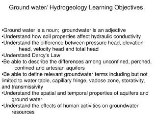
Ground water/ Hydrogeology Learning Objectives. Ground water is a noun; groundwater is an adjective Understand how soil properties affect hydraulic conductivity Understand the difference between pressure head, elevation head, velocity head and total head Understand Darcy’s Law

E N D
Ground water/ Hydrogeology Learning Objectives • Ground water is a noun; groundwater is an adjective • Understand how soil properties affect hydraulic conductivity • Understand the difference between pressure head, elevation • head, velocity head and total head • Understand Darcy’s Law • Be able to describe the differences among unconfined, perched, • confined and artesian aquifers • Be able to define relevant groundwater terms including but not limited to water table, capillary fringe, vadose zone, storativity, and transmissivity • Understand the spatial and temporal properties of aquifers and • ground water • Understand the effects of human activities on groundwater • resources
Ground water factoids • Scientists estimate groundwater accounts for more than 95% of all fresh water available for use. • Approximately 50% of Americans obtain all or part of their drinking water from groundwater. • Nearly 95% of rural residents rely on groundwater for their drinking supply. • About half of irrigated cropland uses groundwater. • Approximately one third of industrial water needs are fulfilled by using groundwater. • About 40% of river flow nationwide (on average) depends on groundwater.
Zone of Aeration pores filled with both air and water Water held against gravity by surface tension Soil water/ soil moisture Zone of Saturation pores filled only with water Water drained through soil under influence of gravity. Ground Water Zones of Subsurface Water
Essential components of groundwater The rate of infiltration is a function of soil type, rock type, antecedent water, and time. The vadose zone includes all the material between the Earth’s surface and the zone of saturation. The upper boundary of the zone of saturation is called the water table. The capillary fringe is a layer of variable thickness that directly overlies the water table. Water is drawn up into this layer by capillary action. S. Hughes, 2003
How does the geology affect the existence of ground water? • What is an aquifer? A permeable, water-containing unit. - Water enters from recharge. - Temporarily stored. - Leaves by flow to streams (baseflow) or springs, or to wells - Has sufficient water to be usable
What is an unconfined aquifer? • They are not sealed off at any point. • Recharge can occur anywhere. • Water at water table under atmospheric pressure. • Must pump to remove water
What is a confined (or artesian) aquifer? • Sealed off • Transmits water down from recharge area • Water confined in aquifer unless drilled. - Water under hydrostatic pressure. - Water rises; well may flow.
Artesian well spouts water above land surface in South Dakota, early 1900s. Heavy use of this aquifer has reduced water pressure so much that spouts do not occur today Betsy Conklin for Dr. Isiorho
discharge=2000 ft3/s No tributaries here discharge=4000 ft3/s How is this possible?
Ground Water and Surface Water • These are almost always connected • If a stream contributes water to the aquifer it’s called a “losing stream” • If a stream receives water from the aquifer it’s called a “gaining stream” • Same stream can be both at different places or at different times
Perennial Stream (effluent) (from Keller, 2000, Figure 10.5a) • Humid climate • Flows all year -- fed by groundwater base flow (1) • Discharges groundwater S. Hughes, 2003
Ephemeral Stream (influent) (from Keller, 2000, Figure 10.5b) • Semiarid or arid climate • Flows only during wet periods (flashy runoff) • Recharges groundwater S. Hughes, 2003
Groundwater flow patterns are controlled by several factors: • Elevation and location of recharge and discharge areas. • Heterogeneity of geologic material • Thickness of material • Current or historic land use practices • Presence of streams, lakes, or springs can also greatly influence groundwater patterns. (Fetter 2001)
Porosity: % by volume of an earth material that is pore space. Primary porosity depends upon: - shape of grains - arrangement of grains - size distribution - compaction/cement’n Permeability: ability of an earth material to transmit water Depends upon - porosity - degree and size of interconnecting pores between larger pores How does ground water move?
What are some typical values of porosity and permeability? • Porosity clay 45-55 % sand 30-40 sandstone 10-20 shale 1-2 limestone 1-10 (or larger) • Permeability: varies over several orders of magnitude. Expressed as a rate, e.g. ft/day
Darcy’s Law • formulated by Henry Darcy based on the results of 1855 and 1856 experiments • stating that the flow rate of water through porous materials is proportional to the hydraulic head drop and the distance (hydraulic gradient ) • The law holds only in laminar flows
laminar flow • smooth, viscosity dominated flow. the direction of motion at any point remaining constant as if the fluid were moving in a series of layers sliding over one another without mixing • Reynold's number for groundwater Re = d * V * ρ / μ where d= grain diameter, (usually d30), V = velocity ρ = density of water μ = viscosity of water • Laminar flow Normally Re < 1 Never > 10
Bernoulli's equation • describes the behavior of a fluid moving along a streamline v2 + z + p 2g g Velocity Head + Elevation Head + Pressure Head In ground water v is so small that can ignore Datum
Darcys’ velocity v = k i p1 i = h / L h = (p1 + z1) - (p2 + z2) h is the change in hydraulic gradient between point 1 and point 2 p2 z1 z2 Datum L
Darcy’s Law • V = k * i • V : Flow Velocity • k : Hydraulic Conductivity • (The rate at which a soil allows water to move through it ) • i : Hydraulic Gradient; i = h / L • (Change in hydraulic head per unit of horizontal distance )
Darcy’s Law • Q = V * A • = k * i * A = Darcy’s Law • A : Cross-sectional area of the Soil • k = saturated hydraulic conductivity • i = the change in hydraulic gradient • divided by the distance over which the • gradient changed
Hydraulic Conductivity, k • Soil grain size • Structure of the soil matrix • pore size distribution • pore shape • porosity • Type of soil fluid • fluid density • fluid viscosity • Saturation
h L A How to get k (lab) • Constant-head conductivity test • Q = K i A (remember Q= VA and V = Ki) • i = h / L so Q = K (h / L) A • K = Q * (L / Ah) • Q : Discharge • A : Cross-sectional area
How to get k (field) • Pumping methods / Tracking methods • Auger-hole method • Saturated soil materials near the ground surface in the presence of a shallow water table. • pumping the water out of an auger-hole extending below the water table and then measuring the rate of the rise of the water in the hole • Tracking with dyes, chemicals, radiation, or electrical conductivity
(Ward and Trimble 2004) • Elevation head is the position of a particle relative to some standard measurement plane, sea level, etc. • Pressure head is the height of a column of fluid that will produce a given pressure.
(Ward and Trimble 2004) • Groundwater contours at streams form a V, they point upstream when they cross a gaining stream and pointing downstream when they cross a losing stream. • When a stream has a greater level than the water in a aquifer the water in the stream recharges the groundwater. This is common in the western U.S. where stream begin high in the mountains and flow in alluvial fans formed at the base.
Monitoring Wells and Piezometers Water levels within wetlands and adjacent to streams involves investigating shallow groundwater regimes. Monitoring wells: have perforation extending from just below the ground surface to the bottom of the pipe. Piezometers: are perforated only at the bottom of the pipe. (WRP TN HY-IA-3.1)
(WRP TN HY-IA-3.1) • Monitoring Well: Water levels in pipe is the result of intergraded water pressure along the entire length of pipe. • Piezometer: Water level inside the pipe is the result from water pressure over a narrow zone of the pipe.
Instrument Selection • Monitoring Wells • Determining timing, duration, and frequency of the water table • Collected data from various wells used to construct groundwater contour maps or potentiometric surface maps • Piezometers • Determining recharge or discharge • Determining ground water flow direction • Determine if perching layers are present
Ground water management issues • Vegetation removal can decrease interception and ET losses • Leads to increase soil moisture- higher water tables • Ground water extraction exceeding recharge • Leads to higher pumping costs • Land subsidence • Sea water intrusion if coastal
Ground water management issues • Urbanization can decrease recharge opportunity • Decrease soil storage, decrease low flows • Ground water contamination • Improper dumping of contaminants • Difficult to clean up
Problems associated with extreme groundwater withdrawal • Dry Wells – cone of depression already seen • Saltwater contamination near coast • Groundwater withdrawal causes saltwater to be drawn into coastal wells, contaminating supply • Contamination of Wells with sewage • Formation of Collapse Sinkholes
Groundwater Overdraft • Overpumping will have two effects: • 1. Changes the groundwater flow direction. • 2. Lowers the water table, making it necessary to dig a deeper well. • This is a leading factor in desertification in some areas. • Original land users and land owners often spend lots of money to drill new, deeper wells. • Streams become permanently dry. S. Hughes, 2003
Groundwater Overdraft • Almost half the U.S. population uses groundwater as a primary source for drinking water. • Groundwater accounts for ~20% of all water withdrawn for consumption. • In many locations groundwater withdrawalexceeds natural recharge rates. This is known as overdraft. • In such areas, the water table is drawn down "permanently"; therefore, groundwater is considered a nonrenewable resource. • The Ogallala aquifer underlies Midwestern states, including Texas, Oklahoma, and New Mexico, while California, Arizona and Nevada use the Colorado River as their primary water source. All show serious groundwater overdraft. S. Hughes, 2003
Groundwater Overdraft in the Conterminous U.S. (from Keller, 2000, Figure 10.13a) S. Hughes, 2003
where current ground moisture is significantly lower than the long-term average, http://www.circleofblue.org/waternews /wp-content/uploads/2011/12/GRACE_GWS.png
Groundwater Overdraft • Water-level changes in the Texas--Oklahoma-High Plains area. • The Ogallala aquifer -- composed of water-bearing sands and gravel that underlie about 400,000 km2. • Water is being used for irrigation at a rate up to 20 times more than natural recharge by infiltration. • Water level (water table) in many parts has declined and the resource eventually may be used up. (from Keller, 2000, Figure 10.13b) S. Hughes, 2003