Download
1 / 27
270 likes | 399 Views
This presentation outlines key efforts by the US federal government to develop and implement coastal and marine geospatial data sharing systems. Attendees will gain insights into existing systems such as NOAA's Coastal Services Center, the National Spatial Data Infrastructure (NSDI), and Geospatial One-Stop, alongside planned initiatives like the Ocean Action Plan. Emphasis is placed on collaboration with state and local managers and the role of geospatial standards. The session covers various projects, data products, and the significance of integrated ocean observing systems.

E N D
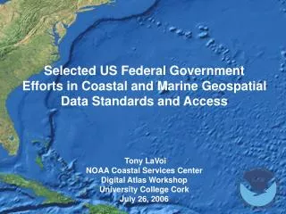
Selected US Federal Government Efforts in Coastal and Marine Geospatial Data Standards and Access Tony LaVoiNOAA Coastal Services CenterDigital Atlas WorkshopUniversity College CorkJuly 26, 2006
Presentation Goal and Outline Objective: Workshop attendees will have an understanding of selected existing and planned coastal and marine geospatial data sharing systems within the US federal government Existing Systems • NOAA Coastal Services Center Overview and IMS Template • National Spatial Data Infrastructure (NSDI) and Federal Geographic Data Committee (FGDC) • Geospatial One-Stop Data Portal • National Ocean Service (NOS) Data Explorer Planned Systems • Ocean Action Plan Ocean Mapping Priorities • Inventory of Ocean and Coastal Mapping Programs and Datasets • Integrated Ocean Observing Systems Data Transport Methods
NOAA Coastal Services Center Mission • Linking People, Information, and Technology in the Coastal Zone Customers and Partners = State and Local Coastal Managers • Regulatory agencies • GIS and remote sensing staff • Planners • Scientists • Emergency preparedness Primary Themes • Coastal Hazards • Coastal Habitat • Integrated Ocean Observing Systems Annual Operating Plan • Approximately 125 projects per year • 90% have local partner who sets requirements Agency Funding • CSC funded through government appropriations
Primary Geospatial Products and Services Data Development (private contract and in-house) • Coastal topography (IfSar and Lidar) • Coastal landcover and change (Landsat-based) • Coastal imagery (high res satellite, digital cameras) • Benthic and Submerged Aquatic Vegetation • Open licensing and data distribution Application Development (ESRI and OpenSource) • Maintain 3-tier development architecture and testing lab • Desktop and Internet; DSS and data distribution Geospatial Standards • Active in multiple standards bodies (OGC, ISO, FGDC, FEA) • Dual role – develop and promote standards Training • Develop and teach full range of GIS (intro and intermediate), Remote Sensing, GPS, and metadata courses Grants • Competitive grant programs to fund state-level projects (CSC support includes both $$$ and staff support [data, coding])
CSC Web Mapping Template • CSC maintains approximately 50 IMS sites for a wide variety of purposes • Hurricane Tracks, Lidar Data Distribution, River Flood Modeling, Coastal Landcover Change, Ocean Planning and Boundaries • Decision made three years ago to move to a standard template for almost all IMS sites (except when requirements dictate otherwise) • Template implementation uses ESRI ArcIMS HTML viewer • Emphasis on reusable and sharable code, new functionality is added regularly • Reduces development time and costs + eases migration with new code releases • Enhances user experience – learn CSC tools once, use on many sites • Newest version in development provides the same look & feel and functionality but built on MapServer code base • OpenSource solution • MapServer is not as feature rich or scalable as ArcIMS
Presentation Outline Existing Systems • NOAA Coastal Services Center Overview and IMS Template • National Spatial Data Infrastructure (NSDI) and Federal Geographic Data Committee (FGDC) • Geospatial One-Stop Data Portal • National Ocean Service (NOS) Data Explorer Planned Systems • Ocean Action Plan Ocean Mapping Priorities • Inventory of Ocean and Coastal Mapping Programs and Datasets • Integrated Ocean Observing Systems Data Transport Methods
FGDC and NSDI • Federal Geographic Data Committee (FGDC) is a 19-member interagency committee, organized in 1990 under OMB Circular A-16, that promotes the coordinated use, sharing, and dissemination of geospatial data on a national basis • FGDC funded through Dept of Interior appropriations and in-kind support from others • In 1994, Presidential Executive Order 12906 called for the nation’s development of the National Spatial Data Infrastructure (NSDI) (US component of Global NSDI) • Current and accurate geospatial data will be readily available to contribute locally, nationally, and globally to economic growth, environmental quality and stability, and social progress • NSDI Components • Clearinghouse - need to find and access data (now GOS) • Metadata - need to know characteristics of data • Framework - need for common sets of data • Standards/Technology - need to transfer/integrate data • Partnerships - need to leverage resources • NSDI composed of 33 data themes of national significance • Seven Framework Themes – e.g. geodetic control; transportation; hydrography; topography • Marine and Coastal included – e.g. maritime baseline; marine boundaries; shoreline; bathymetry
Presentation Outline Existing Systems • NOAA Coastal Services Center Overview and IMS Template • National Spatial Data Infrastructure (NSDI) and Federal Geographic Data Committee (FGDC) • Geospatial One-Stop Data Portal • National Ocean Service (NOS) Data Explorer Planned Systems • Ocean Action Plan Ocean Mapping Priorities • Inventory of Ocean and Coastal Mapping Programs and Datasets • Integrated Ocean Observing Systems Data Transport Methods
Geospatial One-Stop (GOS) What is it? • One of 24 E-GOV projects initiated to enhance federal government service delivery (only geospatial project) • GOS Goal – provide single point of access for all federal (and some state and private) geospatial data sets • All FGDC member agencies required to participate and fund project (cash and in-kind resources) – operating budget of ~$3.0M + agency in-kind support • Managed by one federal agency (Department of Interior) but overseen by 8-member Board of Directors (4 Federal representatives and 4 non-Federal) • Site organized around Communities (Data and Special Topics) Technical Implementation • Site developed and managed by ESRI with Google (enhanced searching) and IBM (portlets) • System driven by FGDC metadata records (125K) • Components include search interface, IMS tool, communities, geospatial marketplace, metadata development tools
GOS – How it Works Main Navigation Tabs Google Search Communities
GOS – How it Works Result OptionsView SummaryFull MetadataAdd to MapGo to Web site
Perspectives on GOS Positives • Participation by all federal agencies (some more than others) • Stable funding and support (agencies are taxed and required to provide in-kind support) • Dedicated GOS project office and staff • Strong private sector involvement (ESRI, Google, IBM) • Diverse Board of Directors Structure Negatives • Searching results need to be refined to prioritize ‘best’ datasets • Too much information given current searching algorithms • Automated metadata harvesting never realized (manual process) • Need to provide site usage (amount and profile) to partner agencies • No data delivered via site – links to data provider • GOS Marketplace has not met initial goals
Presentation Outline Existing Systems • NOAA Coastal Services Center Overview and IMS Template • National Spatial Data Infrastructure (NSDI) and Federal Geographic Data Committee (FGDC) • Geospatial One-Stop Data Portal • National Ocean Service (NOS) Data Explorer Planned Systems • Ocean Action Plan Ocean Mapping Priorities • Inventory of Ocean and Coastal Mapping Programs and Datasets • Integrated Ocean Observing Systems Data Transport Methods
NOS Data Explorer - Why Build It? • NOAA\National Ocean Service creates many of the key US coastal datasets • Geodetic control • Nautical Charts - ENCs • Shoreline • Bathymetry • Marine boundaries • Environmental Sensitivity Index • Coastal Hazards • Tides and Water Levels • Prior to Data Explorer, users must navigate multiple sites to find data • Variety of data delivery approaches • No single interface for previewing composite data at one location • Complexity of discovery and delivery
Data Explorer Basics and Roles Data Explorer Basics • Goal - centralized searching and delivery of datasets and metadata from multiple NOS program offices from one Internet site • Does not replace existing program office data access sites or require any substantial additional work from them (do no harm + add no burden) • Connectivity provided through open standards (OpenGIS, XML, TCP/IP, HTTP) • Hosts 75 unique data layers and 350+ unique metadata records • Governance – core developer team and program office representatives • Funded via support of key program offices doing DE development (three offices) What does the Data Explorer core site hold? • Metadata records from program offices • Inventory files or “footprints” for each dataset • Inventory of “services” – how to connect to each dataset What do the program offices maintain? • Keep metadata and footprint inventory up to date • Store all data and provide access via database connection, ArcIMS, OGC service, or FTP files
Data Explorer DataExplorer Portal Consistent Interfaces Application Framework Tier Data Access Interface “Adaptors” Remote Data Providers Existing Agency Data Access Interfaces Agency Data Holdings Repository Nautical Charts Geodetic Control Tides & Water Shore-line Corals Technologies and Framework Software • ESRI ArcIMS – Map image and data stream construction • ESRI ArcSDE – Broker inventory and portal knowledge repository • JSP/JSTL – Web-UI construction, system flow control and error handling • JDBC – data source connectivity Technologies • Client: HTML, JavaScript • Application:Java, XML • Database:SQL Server & office specific access
Data Explorer Front Page Site OptionsData by TopicsData Web SitesTools and ResourcesSearch for Data
Data Explorer – How it Works Search OptionsBy GeographyBy KeywordCombination
Data Explorer – How it Works Data Exploration OptionsView MetadataVisit Data Web SiteGet Data
Data Explorer – How it Works Add additional data to same geography Final StepsEnter email addressDE clips datasets from all host sitesDatasets and metadata zipped into one packageNotification emailed to user when readyResultant zip package resides on site for 72 hoursSearch parameters maintained in case needed
Perspectives on Data Explorer Positives • Good participation across all program offices • True access to distributed datasets across multiple offices • Code sharing and building networks among software developers • Model for NOAA-wide implementation Negatives • Need more ownership from program offices • Legacy systems caused data access difficulties and required specialized coding to implement system • Scaling and hardening of site needed (buried during Hurricane Katrina) • Not enough done with marketing of site to date (25K unique visits per month average)
Presentation Outline Existing Systems • NOAA Coastal Services Center Overview and IMS Template • National Spatial Data Infrastructure (NSDI) and Federal Geographic Data Committee (FGDC) • Geospatial One-Stop Data Portal • National Ocean Service (NOS) Data Explorer Planned Systems • Ocean Action Plan Ocean Mapping Priorities • Inventory of Ocean and Coastal Mapping Programs and Datasets • Integrated Ocean Observing Systems Data Transport Methods
Future Directions for Coastal and Marine Data Access External Drivers for Mapping • National Research Council Coastal Mapping and Charting Study (2004) • Study suggests the FGDC Marine & Coastal Spatial Data SC pursue shoreline coordination and coastal and ocean data access • U.S. Commission on Ocean Policy (2004-05) • Recommendation “The Federal Geographic Data Committee (FGDC) should coordinate federal ocean and coastal mapping and charting activities with the goal of creating standardized, easily accessible national maps” • U.S. Ocean Action Plan (2005-06) • Recommendation to “Coordinate Ocean and Coastal Mapping Activities” External Drivers for Integrated Ocean Observing Systems • U.S. Ocean Action Plan (2005-06) • Multiple recommendations on need to develop robust data transport technologies and methodologies for ocean and coastal observing systems
OAP Integrated Ocean & Coastal Mapping Inventory • Federal Interagency Working Group on Ocean & Coastal Mapping formed • Tasked with “development of an annual inventory of Federal, Federally-funded, and non-Federal government ocean and coastal mapping and charting programs, operations, and prioritized needs” • No directed funding support from Administration • Currently in requirements development phase • Must be based on FGDC-compliant metadata • Must be accessible via Geospatial One-Stop portal • Must be easy to use and update • Must have query capability • Initial Thoughts on Products • Online Web form to capture programmatic and data set level information (metadata) • Web-based tools to search and access metadata records (both existing & planned) • Web mapping interface to display existing data sets and planned data acquisition
IOOS Data Management and Communications • Increased efforts in coordinating data transport for ocean observing systems • Opportunity to bring together common geospatial datasets (Coastal Atlases) with observing system data streams • Initial focus on a suite of tools and methodologies including OGC Services, OpenSource tools, and COTS software • NetCDF • OPeNDAP • MapServer • XML/GML • ArcIMS • Vocabularies and Ontologies • Metadata
Presentation URLs NOAA Coastal Services Center:www.csc.noaa.gov Federal Geographic Data Committee: www.fgdc.gov FGDC Marine & Coastal Spatial Data Subcommittee: www.csc.noaa.gov/mcsd FGDC Marine Boundary Working Group: www.csc.noaa.gov/mbwg Geospatial One-Stop: www.geodata.gov NOS Data Explorer: www.nos.noaa.gov/dataexplorer US Ocean Action Plan: ocean.ceq.gov/actionplan.pdf Ocean.US Community Information Repository: www.ocean.us/cir Coastal GeoTools ’07 Conference (March 2007): www.csc.noaa.gov/geotools Contact Information: Tony LaVoi NOAA Coastal Services Center Charleston, South Carolina Tony.Lavoi@noaa.gov