Download
1 / 1
10 likes | 399 Views
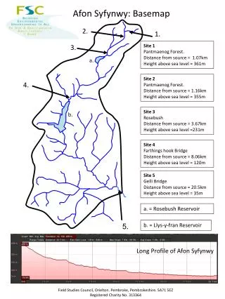
Afon Syfynwy: Basemap. 2. 1. Site 1 Pantmaenog Forest. Distance from source = 1.07km Height above sea level = 361m. 3. a. Site 2 Pantmaenog Forest. Distance from source = 1.16km Height above sea level = 355m. 4. Site 3 Rosebush Distance from source = 3.67km

E N D
Afon Syfynwy: Basemap 2. 1. Site 1 Pantmaenog Forest. Distance from source = 1.07km Height above sea level = 361m 3. a. Site 2 Pantmaenog Forest. Distance from source = 1.16km Height above sea level = 355m 4. Site 3 Rosebush Distance from source = 3.67km Height above sea level =231m b. Site 4 Farthings hook Bridge Distance from source = 8.06km Height above sea level = 120m Site 5 Gelli Bridge Distance from source = 20.5km Height above sea level = 35m a. = Rosebush Reservoir 5. b. = Llys-y-fran Reservoir Long Profile of Afon Syfynwy Field Studies Council, Orielton. Pembroke, Pembrokeshire. SA71 5EZ Registered Charity No. 313364