Download
1 / 4
40 likes | 113 Views
An Innovative Observational Network for Critical Arctic Gateways: Understanding Exchanges through Davis (and Fram) Strait. Craig Lee, Jason Gobat, Richard Moritz, Kate Stafford Applied Physics Laboratory, University of Washington Brian Petrie Bedford Institution of Oceanography

E N D
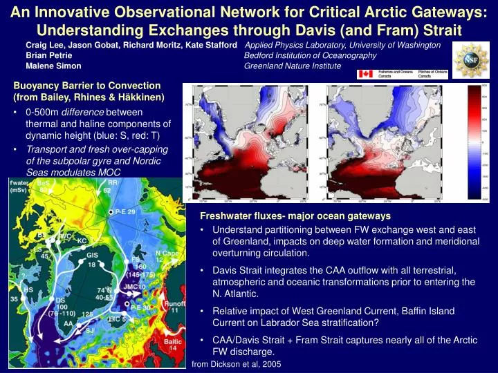
An Innovative Observational Network for Critical Arctic Gateways: Understanding Exchanges through Davis (and Fram) Strait Craig Lee, Jason Gobat, Richard Moritz, Kate Stafford Applied Physics Laboratory, University of Washington Brian Petrie Bedford Institution of Oceanography Malene Simon Greenland Nature Institute Buoyancy Barrier to Convection (from Bailey, Rhines & Häkkinen) • 0-500m difference between thermal and haline components of dynamic height (blue: S, red: T) • Transport and fresh over-capping of the subpolar gyre and Nordic Seas modulates MOC • Freshwater fluxes- major ocean gateways • Understand partitioning between FW exchange west and east of Greenland, impacts on deep water formation and meridional overturning circulation. • Davis Strait integrates the CAA outflow with all terrestrial, atmospheric and oceanic transformations prior to entering the N. Atlantic. • Relative impact of West Greenland Current, Baffin Island Current on Labrador Sea stratification? • CAA/Davis Strait + Fram Strait captures nearly all of the Arctic FW discharge. from Dickson et al, 2005
S • Challenges • Small internal deformation scale- dynamically wide strait. • Broad West Greenland shelf. • Ice cover & icebergs. • Freshwater moves in thin (~50 m) surface layer. • Quantify liquid & ice contributions at monthly to inter-annual time scales. Moorings:Ice draft/velocity, absolute geostrophic velocity, low-mode u, T, S structure, marine mammals (‘06-’08) Shelf Moorings: Low-cost (~$10k) ICECAT for T-S near ice-ocean interface, upward looking acoustic current profilers and bottom-mounted T-S. Acoustically-navigated Gliders: Repeated sections (5 km, resolves deformation scale) at O(week) timescales between 500-m isobaths. Samples at ice-ocean interface. Temperature, salinity, dissolved oxygen (other?). Ship-based Hydrographic Sections:Autumn. Biogeochemical tracers (nutrients, trace metals, TOC, TAlk, CFCs, oxygen isotopes. Spans broad region from S. Baffin Bay to N. Labrador Sea.
Seaglider and Sensors • Hull length: 1.8 m, Wing span: 1.0 m • Mass: 52 kg • Surface to 1000 m. • Slow: horizontal speed 0.1 - 0.45 m/s (~22 km or 12 nm per day @0.25 m/s) • Vertical speed 0.06 m/s (minimum) • Endurance depends on ambient stratification, dive depth and desired speed • Longest range to date: 3900 km • Longest endurance to date: 31 weeks • Sensors: SBE conductivity & tempreature, SBE43 or Aanderaa optode dissolved oxygen. Fluorometers, backscatter, ADCP may be possible. Operations beneath ice require acoustic navigation (RAFOS), advanced autonomy. Acoustic data upload desirable for ‘insurance’. First section beneath ice-covered western Davis Strait in Dec 2006… the system works, but there have also been setbacks associated with platform reliability. IPY/AON developments include refining under-ice glider system, implementing moored ‘data depot’ for periodic data offload while operating under ice. • ICECAT for shallow shelves, moorings • Samples in ice-threatened near-surface layer. • Shallow element expendable, data logged below. • Inexpensive (~$10k), deploy many. • 2004(1), 2005(2), 2006(4)… • Contributing this technology to Bering Strait, other projects.
Autumn 2004 – Autumn 2010 • One cruise (mooring/glider service, hydrographic surveys) each autumn. • Data dissemination:- Project web site.- As specified by AON and ARCSS data managers.- DAMOCLES WP6. • Working on near real-time distribution for glider data… not yet there. • Science and engineering collaborations with:Canadian IPY (Melling, Carmack projects)DAMOCLES (AWI, Fram Strait)Norwegian IPY (NMI, NPI, Station M line)Nares Strait/Baffin and Hudson Strait (proposed) • Platform development for Switchyard.