Download
1 / 30
300 likes | 410 Views
This comprehensive overview explores key concepts in XML for scientific data, Geographic Information Systems (GIS), and spatial databases. It contrasts raster and vector data models, highlights the importance of provenance, and delves into interesting data types like time series and spatial arrays. The discussion extends to multidimensional indexing and schema-aware versus schema-oblivious XML storage approaches. Understanding these components is vital for efficient data management and query performance in various scientific and spatial applications.

E N D
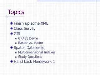
Topics • Finish up some XML • Class Survey • GIS • GRASS Demo • Raster vs. Vector • Spatial Databases • Multidimensional Indexes • Study Questions • Hand back Homework 1
XML for Science • Recall features of Science Data: • Read-oriented access • Provenance • who, what, when, where, why • Interesting Data Types • timeseries • spatial • arrays • images • Scale
XML for Science • Read-oriented access? • perfect! • Provenance • requires some flexibility; no problem • Interesting Data Types • …and special file formats • Scale • could get ugly
Interesting Data Types • Data locked in binary file formats • Binary Format Description Language • [Myers, Chappell 2000] • Data Format Description Language • [OpenGrid Project] • Retrofitting Data Models • [Howe, Maier SSDBM 2005] • PADX • [Fernandez et al, PLANX 2006] • XDTM • [Foster, Voeckler et al. Global Grid Forum 2005]
dining-room manufacturer table chair “The Wood Shop” type wood price wood price quantity “round” “maple” 199.99 “maple” 39.99 6 XML Storage • Use RDBMS as your storage engine • Two approaches: • Schema-aware • Schema-oblivious
XML Storage: Schema-aware DiningRoom(Manufacturer, Chairs, Quantity, Table) Chair(SKU, Wood, Price) Table(SKU, Wood, Type, Price)
XML Storage: Schema-oblivious • Remember fancy node-labeling schemes… Edge(NodeId, Tag, Value, ParentNodeId)
dining-room manufacturer table chair “The Wood Shop” type wood price wood price quantity “round” “maple” 199.99 “maple” 39.99 6 Left/Right Labeling 0 34 4 5 10 … 1 2 3 6 9 7 8 Which queries are easy and fast? What did we say the problems were?
dining-room manufacturer table chair “The Wood Shop” type wood price wood price quantity “round” “maple” 199.99 “maple” 39.99 6 Path Labeling 0 0.1 0.0 0.0.0 0.1.2 0.1.1 0.1.0 0.1.2.0 0.1.1.0 0.1.0.0 What queries are fast and/or easy? What did we say the problems were?
Represent This source: USA Today Weather
Represent This source: USA Today Weather
Represent This Source: www.mapsofworld.com/
Raster-Vector Data Model Raster Vector Real World
Vector Data • The world is a collection of objects • Points • Lines • Polygons
GIS: Geographic Information Systems • GIS is a collection of: • file format converters and readers • algorithms (visibility, buffer, etc.) • visualization tools • georeferencing libraries…
Geodesy: Elevation topographical surface geoid elliptical surface
Geodesy: Map Projections • Cylindrical (Mercator) • Conical • Planar (Azimuthal) transverse secant tangent
Map projection http://www.geog.ucsb.edu/~dylan/mtpe/geosphere/topics/map/map1.html
Spatial Databases • Spatial Database is an RDBMS equipped with: • spatial types (points, lines, regions) • spatial functions (georeferencing, other algorithms) • multi-dimensional indices
Spatial Databases • Non-spatial queries: • List all gas stations owned by Bob • List all unpaved streets • List galaxies with luminosity > x • Spatial queries: • List all gas stations with one mile of the river • List all gas stations touching an unpaved street • List galaxies within 2 arcmin of a quasar
Spatial Predicates • Each value has type Geometry • plus a subtype: • point, line, polyline, polygon • Spatial Predicates • Geo Overlap(Geo, Geo) • bool Contains(Geo, Geo) • Geo Boundary(Geo) • bool Touches(Geo, Geo) • Geo Nearest(Geo, [Geo]) • Geo Nearest(Geo, [Geo])
Multidimensional Indices • How do we answer topological questions efficiently? • B-Tree: one dimension only
Multidimensional Indices • One way: Impose a total order on the objects, then use an ordinary one-dimensional index • Ideas?
Space Filling Curves • How do we organize objects on disk so proximity is preserved?