Download
1 / 28
280 likes | 401 Views
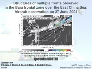
Structures of multiple fronts observed in the Baiu frontal zone over the East China Sea: Aircraft observation on 27 June 2004. KOREA. CHINA. KYUSHU. Institute of Observational Research for Global Change (IORGC), Japan Agency for Marine-Earth Science and Technology Qoosaku MOTEKI.

E N D
Structures of multiple fronts observed in the Baiu frontal zone over the East China Sea: Aircraft observation on 27 June 2004 KOREA CHINA KYUSHU Institute of Observational Research for Global Change (IORGC), Japan Agency for Marine-Earth Science and Technology Qoosaku MOTEKI Coauthors are T. Shinoda, S. Shimizu, S. Maeda, H. Minda, K. Tsuboki, H. Uyeda: HyARC, Nagoya Univ. T. Kato: Meteorological Research Institute
Multiple fronts in the Baiu frontal zone over the East China Sea (Moteki et al., 2004, JMSJ)
Aircraft observation on 27 June 2004 • In situ measurement: p, T, Td, u, v, w at 500 m MSL, 0852-0950 JST • Drop sondes: dropped from 12 km MSL at 6 points, 1023-1209 JST KOREA CHEJU CHINA KYUSHU NAHA
Objectives of this study • To show observational evidence for the fact that multiple fronts exist inside the Baiu frontal zone. • To quantitatively show their features (horizontal gradients of PT, Qv, etc.)
Aircraft observation on 27 June 2004 • In situ measurement: p, T, Td, u, v, wat 500 m MSL, 0852-0950 JST • Drop sondes: dropped from 12 km MSL at 6 points, 1023-1209 JST
Definitions on the basis of cloud image at 10 JST Baiu frontal zone: the zone with a north-south width of about 500 km including 3 cloud zones. KOREA CHEJU CHINA KYUSHU NAHA
Definitions on the basis of cloud image at 10 JST Frontal zone 1 (FZ1): the zone on the southern side of BFZ. Frontal zone 2 (FZ2): the zone in the middle of BFZ. Frontal zone 3 (FZ3): the zone on the northern side of BFZ. KOREA CHEJU CHINA KYUSHU NAHA
Vertical cross section based on dropsonde data PT Qv S S N
Vertical cross section based on dropsonde data RH Melting level S N
Schematic illustration of the multiple frontal structures S N
Conclusions The multiple frontal structures that formed in different time and had different features were observed on 27 June 2004 over the East China Sea. FZ1: small ΔPT, ΔQv=1.7(g/kg/100km), no rainfall. FZ2: ΔPT=6.4(K/100km), ΔQv=3.0(g/kg/100km), strong rainfall. FZ3: ΔPT=3.0(K/100km), ΔQv=3.2(g/kg/100km), moderate rainfall.
Hypothesis Although the Baiu front analyzed on the surface weather map seems to have stagnated, it is replaced with the new front from the old front in a few hours. The new front The new front The old front The old front
Time-Lat. Sec. of TBB(09JST23-09JST28) Synoptic low (passed at 18Z on 24) The position of stationary front L FZ4 FZ0 FZ1 FZ3 FZ2
FZ3 FZ2 FZ1 Confluence term of FGF with RANAL
FZ3 FZ2 FZ1 Confluence term of FGF with RANAL
FZ3 FZ2 FZ1 Shear term of FGF with RANAL
FZ3 FZ2 FZ1 Heating term of FGF with RANAL
FZ3 FZ2 FZ1 FGF with RANAL
FZ3 FZ2 FZ1 Convergence with RANAL (09JST27)
Convergence with RANAL (21JST26) FZ2 FZ1