Download
1 / 30
300 likes | 320 Views
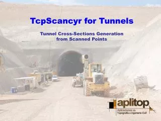
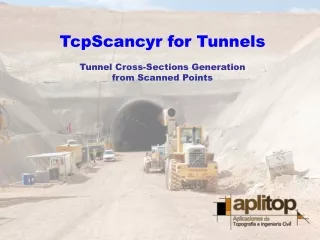
TcpScancyr for Tunnels Tunnel Cross-Sections Generation from Scanned Points. INDEX. Project Data Template Definition Points Management Filtering Tools Cross- Sections Computing and Editing Areas and Volumes Report Tunnel Tour. Project Data. Data Entry. Horizontal alignment

E N D
TcpScancyr for Tunnels Tunnel Cross-Sections Generation from Scanned Points
INDEX • Project Data • TemplateDefinition • Points Management • Filtering Tools • Cross-Sections Computing and Editing • Areas and VolumesReport • Tunnel Tour
Data Entry • Horizontal alignment • Vertical alignment • Superelevations • Stations • Templates • Scanned points
Alignment Definition • File Conversion (LandXML, Inroads, MX-Road, MDT...) • Numerical Definition • Graphical Representation • Analytic Informaciton • Real-time Analysis
Template Definition • Numerical definition from arcs and lines • DXF file import and TcpTunel CAD files • Multiple templates and layers • Definition of control points
Template Definition • Different templates can be defined along the alignment • Horizontal and vertical position of alignment must be given • Control points for vertical alignment and superelevations • Destroy Height
Points Management • ASCII files import as sessions • Supported Formats • ASCII XYZ • Cyclone PTS & PTX • Faro FLS • Grafinta FZS • Automatic analysis and classification • Virtually unlimited capacity
Views • Isometric and perspective views • Zoom, 3-D rotation and orbit in real-time • Layer control • Movement along alignment • Point Information • 3D Distance measurement
Points Symbology • Bases • Alignment offset • Distance to station • Height difference • Angle • Distance to template • Scanned colour • In/Out
Filtering Tools • Station, Offset and Height • Angle • Distance to template • Manual selection
Angle Filtering • Station range • Origin point, start and end angles variables • Representation in real-time
Manual Filtering • Selection method: • Rectangle • Circle • Polygon • Clear selection • Include selection • Invert selection
Cross-Sections Calculation • It is not needed to define tunnel cross-section • Bandwith and interval given by user • Singular Points • Vertical or perpendicular to vertical alignment • Optional smoothing
Cross-Sections Views • Front or perspective visualization • Layer control allowing display or hide points, theorical and measured cross-sections …
Cross-Sections Editing • Tools to add, move or delete vertices or groups of vertices • Invalid points can be removed and recalculate cross-sections
Cross-Sections Drawing • Interactive drawing and DXF export • Control of element to draw • Single or by sheet drawing
Informes de Superficies y Volúmenes • Calculation of areas and volumes • Reports by layers • Advanve and destroy reports • Cross-Sections comparation • Export to Excel and HTML
Informes de Superficies y Volúmenes • Drawing of infra and over-excavation • Numerical results by layers
Other Reports • Alignment deviation from control points • Coordinates report • Stakeout
Recorrido por el Túnel • Control of speed, direction and visible distance • Layer control • Video export
TcpScancyr for Tunnels Tunnel Cross-Sections Generation from Scanned Points