Geosciences Information Network (GIN)
310 likes | 457 Views
Geosciences Information Network (GIN). Lee Allison, Arizona Geological Survey Linda Gundersen, U.S. Geological Survey Steve Richard, Arizona Geological Survey. 162 million+ websites – if you don’t have a website, you don’t exist. Prediction.

Geosciences Information Network (GIN)
E N D
Presentation Transcript
Geosciences Information Network (GIN) Lee Allison, Arizona Geological Survey Linda Gundersen, U.S. Geological Survey Steve Richard, Arizona Geological Survey
162 million+ websites – if you don’t have a website, you don’t exist. Prediction In 5-10 years, if your data are not online in an integrated, interoperable network, you won’t exist.
INTEROPERABILITY Simple interface– put plug in wall, get electricity Afghanistan 220 V 50 Hz Andorra 230 V 50 Hz Anguilla 110 V 60 Hz Antigua 230 V* 60 Hz Cayman Islands 120 V 60 Hz Cyprus 240 V 50 Hz Czech Republic 230 V 50 Hz ……
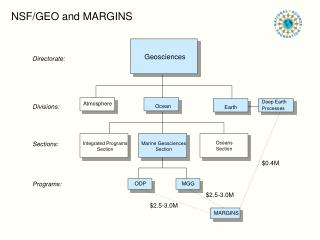
ORGANIZATION: Unique missions of geological surveys - collect, archive, disseminate data Geoscience Information Network (GIN) Web-based Interoperable Distributed 2,000 – 3,000 databases 1000’s of collections 80,000+ geologic maps
Most of the technology exists Challenges are cultural and organizational
Challenges to building community Who sets the standards? Who controls the system? Who makes the decisions?
We agree on a data network that: • is distributed (vs centralized) • is interoperable • uses open source standards and common protocols (OGC, GeoSciML) • respects and acknowledges data ownership • fosters communities of practice to grow • facilitates development of new web services and clients
http – hypertext transfer protocol (& ftp, etc) html – hypertext mark-up language url – universal resource locator browser – built by others Open source standards – Open Geospatial Consortium data interchange tool – GeoSciML distributed data catalogues (National Geologic Map DB; National Data Catalogue, etc) Web services & applications – built by others WWW GIN
Each application has driver for each printer HP Driver1 HP printer CalcompDriver1 Word Processor Brothers Driver1 Calcomp plotter HP Driver2 Brothers printer Spreadsheet CalcompDriver2 • Now Brothers Driver2 Metafile interpreter Laserwriter Printer driver Printing service, uses Metafile= interchange format Word Processor Metafile interpreter Large format inkjet Printer driver Metafile interpreter Film writer Spreadsheet wrapper service wrapper Computer printer services • Old days • Advantages • one driver (wrapper) per application • Application need know nothing about printer—separation of concerns
G S C wrapper GSC GSC GSC sc h e m a W e b U S G S wrapper NGMDB U U SGS SGS C l ien t sc h e m a wrapper S ervice s B G S wrapper B B B GS GS GS sc h e m a G A wrapper G G G A A A sc h e m a Communication between service providers and clients takes place using XML mark up. Interoperability via web service Use of standard markup language means schema mapping only needs to be done once Wrapper implements interface to service — formulate requests, interpret results Participants implement one interface for each service Applications focus on application logic, not data access.
The network is voluntary, not imposed from above Interoperability
Defining GIN • collections of service definitions, interchange formats, and vocabularies • independent of hardware, operating system, or lower-level network protocols • new technology will only require implementation of network elements in a new environment • architecture allows for the use of multiple conventions for different user groups
MODULAR APPROACH • National Geologic & Geophysical Data Preservation Program • $1M per year • National inventory • Metadata catalogue • National Digital Catalog
Mark-up language “wrapper” translates your data GeoSciML developers Cocoon Uppalla, Sweden GeoServerKeyworth, UK CocoonOttawa, Canada Ionic Orleans, France Mapserver Arizona CocoonVirginia, USA Tsukuba, Japan GeoServer Canberra Version 2.0 released Fall 2008 GeoServer Melbourne, Australia
System overview GIN ArcGIS
OneGeology-Europe Compatible Integrated
Geologic map service – prototype for all state geological surveys
GIN DEMO PROGRAM NSF INTEROP GIN • 3 year development of standards, services • Demos in US state geological surveys
EarthChem test bed - linking a large, complex global data system Geochemical data from GEOROC, NAVDAT, PetDB, and USGS = 594,335+ samples
“Circuit Riders” • Part trainer, part management consultant, part computer expert • Write GeoSciML “wrappers” • Guide server configurations • Training, short courses • US$80K for demos across AASG
ADOPTION & DEPLOYMENT • US Dept. of Energy (May, 2009) • National Geothermal Data System (NGDS) • Based on GIN • usd$5M, 5 years • Adopted by US Geothermal Technologies Program
NATIONAL DEPLOYMENT • US DOE “Geothermal Data Development, Collection, and Maintenance” • $20M, 1-5 awards • AASG proposal in preparation
MS SciScope – geospatial data discovery Welcome to SciScope!SciScope is a tool by Microsoft Research to help geoscientists discover data from numerous data repositories with ease through a single, intuitive interface. Users can display multiple map layers related to the scope of their study and interact with geographical features on the map including dams, rivers, water bodies, geology, aquifer systems, ecological regions and river basins.
Geosciences Information Network – (GIN) http://usgin.org, http://lab.usgin.org