Basic Oceanography
320 likes | 512 Views
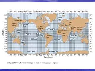
Basic Oceanography. 4 main basins “Super Ocean” – interconnected physico-chem differences = different envts = different communities of organisms Gulfs and seas – enclosed, strong terrestrial influence. Shelf Slope Rise Abyssal plain Mid-ocean ridge Seamount Trench Island arc.

Basic Oceanography
E N D
Presentation Transcript
Basic Oceanography • 4 main basins • “Super Ocean” – interconnected • physico-chem differences = different envts = different communities of organisms • Gulfs and seas – enclosed, strong terrestrial influence
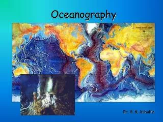
Shelf Slope Rise Abyssal plain Mid-ocean ridge Seamount Trench Island arc Bathymetry – Ocean floor features www.noc.soton.ac.uk/obe/PROJECTS/pap/images/largemap1.jpg
Basin cross section stloe.most.go.th/.../LOcanada6/604/9_en.htm
Slope – cont. boundary, 1500-4000 m, 4° slope, sand to silt-clay, terrigenous and biogenic Submarine canyons – Glacial or river cut @ lower sea levels, carry shelf sediments via turbidity flows Rise – 4000-6000m, 0.1-1° slope, alluvial fans spread by deep currents Shelf Slope Rise Submarine canyons Continental margins • Shelf – to 250 m, 0.1° slope, 50-1000 km width, terrigenous or oolotic sediment, sand – silt, highly productive http://www.neseabirds.com/graphics/figure1.jpg
3.5-5.5 km, <0.1° slope, “marine snow” biogenic Calcareous Siliceous Terrigenous Red clay Abyssal plain http://www.ga.gov.au/image_cache/GA1705.jpg
Red clay – vol. dust, marine debris, zeolite, iron oxides Calcareous tropical-temperate, high prod., max. 4500-5000 m Siliceous - silica available, moderate prod., low calcium carbonate; polar and deep tropical/subtropical http://www.noc.soton.ac.uk/gg/BOSCORF/curatorial/pacific.html
Mid-ocean ridge Global network Plate boundary Sea floor spreading 2-3 km, emerge Iceland, Azores Trenches Subduction Equilibrium w/spreading 10 km melt zone Volcanic arcs PR- 8400m deep Mariana – > 11 km
Temperature • Extremely important in regulating distribution and abundance of organisms • Latitude, depth • Seawater range -1.9 C 40 C
Surface Temperature Homeotherms (endotherms) and Poilkiotherms (ectotherms) – metabolism increase 2x for each 10° increase Temperature based biogeographic zones
Thermocline • Warm surface water, tropics, summer • Declines w/depth • Rapid decline: thermocline • Persistent in tropics, summer • Deeper: isothermal Depth Thermocline Temperature
Density and Ocean Circulation • Temperature, salinity • Themocline and pycnocline separate water masses • Upper or surface and deep • surface T & S vary with latitude, season • deep constant
Wind and Ocean Circulation • Surface water mass in constant motion via waves and currents • Waves – Energy transport, not molecules – no horizontal transport • Currents transport huge volumes of water across vast distances • - result of from major wind bands and Coriolis Force
Waves • Movement of energy only • Function of wind speed, fetch duration • Propagate away from origin • Wave length – distance between crests • Period – time for 2 crests to pass • Wave passage generates motion to depth of ~ ½ WL (“wave base”) • Each 1/9 of WL, orbit diameters drop by ½, so by ½ depth motion imperceptible
Bottom slows energy passage • WL declines, height increases • At 1.3x wave height wave breaks, releases energy
Wind systems and currents • Temperature differences tropics to poles generate winds • Unequal heating • Sun angle: oblique at poles • Albedo (reflectiveness): high at poles • Both reduce light absorption and heat build up • Atmosphere and ocean move heat from tropics Coreolis effect
Coriolis Force • The effect of earth rotation on the direction of the wind. • two reasons, • 1- system of latitude and longitude fixed to a rotating earth, so our frame of reference for a free-moving object above the Earth is constantly changing. • 2 - the amount of turning about a vertical axis varies from a maximum at the poles and minimum at the equator.
Deflection: a missile from the North Pole to Equator; Earth, and the target, has rotated, so it appears that the missile has changed direction.The deflection works the same way for an east-west wind, the path will curve to the right as it moves across the surface.
Coreolis effect - wind • Speed of rotation – movement away from poles decreases rotational speed • Deflection due to earth’s rotation – northward moving deflects wind eastward • No Hemisphere – deflect to right, Southern, to left
Three-cell circulation model • considers effects of coriolis force due to the Earth’s rotation. • Northern and Southern Hemisphere are each divided into three cells of circulation, each spanning 30 degrees of latitude. • Equator, 30° North and South, and 60° North and South. • Hadley, Ferrel, polar cells • Heat transfer away form equator by atmosphere
Hadley Circulation • Tropical air rises, creates low pressure system below • Low level cool air moves in from higher latitudes to replace it • Warm air travels to poles, cools, becomes more dense, sinks • Hadley cell
Primary circulation cells and prevailing wind belts of Earth
Surface currents • a large mass of continuously moving oceanic water • ~40 named currents • Do not move in direction of wind • Interaction of Coriolis effect, wind and land masses • wind friction on water – uneven sea surface, starts water moving • Coriolis effect deflection • contact with the continents deflect currents, creating giant oceanic current circles or gyres.
Gyres • Direction – counterclockwise northern Hemisphere • Indian Ocean exception • West, east sides of gyres • Temperature transfer N-S profound impact • Spiral gyres “pile up” water in center • Antarctic circumpolar current – westerlies blow uninterrupted • Narrow weak counter currents separate gyres - Equatorial countercurrent
Subsurface flows • 90% of water mass movement • Density driven • Arctic and Antarctic model • Deep and bottom water, ice melt
Eckman Spiral – each sheet of water drags on the one below – nettransport is 90o to right (northern hemisphere) of the wind direction