Download
1 / 30
300 likes | 559 Views
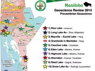
Geoscience Review 2014 Precambrian Geoscience. 1) Rice Lake - Anderson 2) Long Lake Au - Zhou (Waterloo) 3) Mayville – Euclid Lake - Yang 4) Granitoids in Manitoba - Yang 5) Cauchon Lake - Couëslan 6) Eden Lake - Martins, Kremer 7) Highrock Lake - Martins, Kremer

E N D
Geoscience Review 2014 Precambrian Geoscience 1) Rice Lake - Anderson 2) Long Lake Au - Zhou (Waterloo) 3) Mayville – Euclid Lake - Yang 4) Granitoids in Manitoba - Yang 5) Cauchon Lake - Couëslan 6) Eden Lake - Martins, Kremer 7) Highrock Lake - Martins, Kremer 8) Sherridon - Kremer, Couëslan 9) Reed Lake - Gagné, Anderson 10) Snow Lake Au - Rubingh (Laurentian) MB
Rice Lake mine trend: stratigraphy-structure Project location: Rice Lake belt Principal investigators: Scott Anderson (MGS) • Objectives: • Stratigraphy • Structural geology • Mineralization controls • Constrain exploration models • Methods: • Mapping (1:10k, 5k) • Detailed structural analysis • Lithogeochemistry • U-Pb geochronology • Mineral deposits studies Map areas: 2004-2005 (20k) 2011 (5k) In-kind support by: San Gold Corporation (LiDAR and orthophoto) 2013 (10k)
RLMT: stratigraphy-structure • Rationale: • Long Lake burn (2011) • Expand the map coverage • Last mapped in 1949 • Ongoing Au exploration • Methods: • 1:10k mapping • Structural analysis • Lithogeochemistry • U-Pb geochronology • Mineral deposits • 2014 program: • 1 week fieldwork • Detailed mapping • Products for 2014: • Possible Report of • Activities contribution
Geoscience Review 2014 Precambrian Geoscience 1) Rice Lake - Anderson 2) Long Lake Au - Zhou (Waterloo) 3) Mayville – Euclid Lake - Yang 4) Granitoids in Manitoba - Yang 5) Cauchon Lake - Couëslan 6) Eden Lake - Martins, Kremer 7) Highrock Lake - Martins, Kremer 8) Sherridon - Kremer, Couëslan 9) Reed Lake - Gagné, Anderson 10) Snow Lake Au - Rubingh (Laurentian)
Long Lake structure (Au) Project location: Rice Lake belt Principal investigators:Xiaohui Zhou (Ph.D. student) Scott Anderson (MGS) Rice Lake project (San Gold) • Objectives: • Geological setting • Structural evolution • Nature of Au mineralization • Mineralization controls • Absolute ages • Constrain exploration model Central MB project (Bison Gold Res.) • Rationale: • Last mapping 1930’s (GSC) • Structure studies 1960’s (MGS) and 1980’s (GSC) • Build on results of recent MGS mapping • Au deposits (Central MB, Ogama) • Ongoing Au exploration • Partnered with: • U. of Waterloo (Shoufa Lin) • Bison Gold Resources
Long Lake structure (Au) • Methods: • 1:10k mapping (camp-scale) • 1:1k mapping (deposit-scale) • Detailed structural analysis • Mineral chemistry • Lithogeochemistry • U-Pb and Re-Os geochronology 2013 • Work to date: • 2012 program (10 weeks) • 2013 program (12 weeks) • Plans for 2014: • 4 weeks fieldwork • detailed mapping and sampling 2012 • Products for 2014: • Report of Activities contribution • Preliminary map • Technical talk and poster at MMM Convention
Geoscience Review 2014 Precambrian Geoscience 1) Rice Lake - Anderson 2) Long Lake Au - Zhou (Waterloo) 3) Mayville – Euclid Lake - Yang 4) Granitoids in Manitoba - Yang 5) Cauchon Lake - Couëslan 6) Eden Lake - Martins, Kremer 7) Highrock Lake - Martins, Kremer 8) Sherridon - Kremer, Couëslan 9) Reed Lake - Gagné, Anderson 10) Snow Lake Au - Rubingh (Laurentian)
Mayville and Euclid Lake Project location: Bird River greenstone belt Staff involved: Eric Yang, Paul Gilbert Partners: Michel Houlé – GSC (TGI-4 program) Mustang Minerals • Objectives: • Stratigraphy • Geological setting • Tectonic evolution • Mafic-ultramfic intrusions associated Ni-Cu- • PGE-Cr metallogeny • Rationale: • Last mapped in 1980’s (MGS) • Past Cu-Ni producer (New Manitoba Mine) • Various mineral occurrences • Ongoing Ni-Cu-PGE-Cr exploration • Fundamental geological problems
Mayville and Euclid Lake • Methods: • 1:10k scale mapping • Structural analysis • Petrology of mafic-ultramafic • rocks • Mineral chemistry • Lithogeochemistry • Nd-Sm and U-Pb isotopic • studies • Products for 2014: • Report of Activities contribution • Preliminary map • Technical talk and poster • (MB Convention; GAC-MAC) • Timeframe: • Cat Creak (Mayville) 2012 • Cat Lake-Euclid Lake 2013 • Completion of project 2014
Geoscience Review 2014 Precambrian Geoscience 1) Rice Lake - Anderson 2) Long Lake Au - Zhou (Waterloo) 3) Mayville – Euclid Lake - Yang 4) Granitoids in Manitoba - Yang 5) Cauchon Lake - Couëslan 6) Eden Lake - Martins, Kremer 7) Highrock Lake - Martins, Kremer 8) Sherridon - Kremer, Couëslan 9) Reed Lake - Gagné, Anderson 10) Snow Lake Au - Rubingh (Laurentian) MB
Granitoids in Manitoba Project location: Within Manitoba Staff involved: Eric Yang Partners: None • Objectives: • Petrogenetic types • Geodynamical setting • Mineralization potential evaluation • GIS database • Rationale: • Little attentions on granitoids in the past • Primary genetic information well preserved • Different types of granites are associated • with different mineralization • Crustal growth, cratonization, and terrane • juxtaposition
Granitoids in Manitoba • Methods: • Reconnaissance mapping and sampling • Petrography, and petrology • Mineral chemistry • Lithogeochemistry • Nd-Sm and U-Pb isotopic studies • GIS compilation and analysis • Products for 2014: • Report of Activities contribution • Preliminary GIS database • Technical talk and poster (MB Mines • and Minerals Convention; GAC-MAC) • Timeframe: • Southeast Manitoba 2014 • Thompson Nickel Belt and FlinFlon belt 2015 • Lynn Lake belt 2016
Geoscience Review 2014 Precambrian Geoscience 1) Rice Lake - Anderson 2) Long Lake Au - Zhou (Waterloo) 3) Mayville – Euclid Lake - Yang 4) Granitoids in Manitoba - Yang 5) Cauchon Lake - Couëslan 6) Eden Lake - Martins, Kremer 7) Highrock Lake - Martins, Kremer 8) Sherridon - Kremer, Couëslan 9) Reed Lake - Gagné, Anderson 10) Snow Lake Au - Rubingh (Laurentian)
Pikwitonei Mapping Program Project location: Pikwitonei Granulite Domain Partridge Crop 2013 Thompson Staff involved: Chris Couëslan PGD Cauchon 2013 • Objectives: • Interpretive mapping of protolith • Determine relationship to adjacent greenstone belts • Geological setting • Mineral potential TNB Cauchon 2014 O-SD Sipiwesk 2012 • Rationale: • Last mapped in 1970’s (supracrustal rocks not recognized) • Base-metal and gold showings in adjacent greenstone belts
Pikwitonei Mapping Program • Methods: • 1:20 000 scale mapping • Metamorphic/structural analysis • Lithogeochemistry • Nd-Sm and U-Pb isotopic studies • Products for 2014: • Report of Activities contribution • Preliminary map • Technical talk and poster (Mining and Minerals Convention) • Timeframe: • Sipiwesk Lake 2012 • Cauchon Lake 2013+14 • Partridge Crop Lake 2013+15?
Geoscience Review 2014 Precambrian Geoscience 1) Rice Lake - Anderson 2) Long Lake Au - Zhou (Waterloo) 3) Mayville – Euclid Lake - Yang 4) Granitoids in Manitoba - Yang 5) Cauchon Lake - Couëslan 6) Eden Lake - Martins, Kremer 7) Highrock Lake - Martins, Kremer 8) Sherridon - Kremer, Couëslan 9) Reed Lake - Gagné, Anderson 10) Snow Lake Au - Rubingh (Laurentian)
Eden Lake Project location: Eden Lake Staff involved: Tania Martins, Paul Kremer, Chris Couëslan Rationale: The data obtained can be used to assess and identify other areas with potential REE enrichment elsewhere in the THO Objectives: To improve the geological understanding of the granitic rocks that surround the Eden Lake syenitic complex and its related REE mineralization within the larger tectonic framework of the THO Eden Lake complex
Eden Lake • Methodology: • Mapping and sampling of shoreline and inland exposures • identify the various intrusive phases surrounding the Eden Lake carbonatite and their relative emplacement ages • Lithogeochemistry, Sm-Nd and U-Pb isotopic analyses • provide a complete and up to date data set in the Eden Lake area • Products for 2014: • Report of Activities contribution • Preliminary map • Technical talk and poster (MB Mines • and Minerals Convention; GAC-MAC) Mumin (2010)
Geoscience Review 2014 Precambrian Geoscience 1) Rice Lake - Anderson 2) Long Lake Au - Zhou (Waterloo) 3) Mayville – Euclid Lake - Yang 4) Granitoids in Manitoba - Yang 5) Cauchon Lake - Couëslan 6) Eden Lake - Martins, Kremer 7) Highrock Lake - Martins, Kremer 8) Sherridon - Kremer, Couëslan 9) Reed Lake - Gagné, Anderson 10) Snow Lake Au - Rubingh (Laurentian)
Highrock Lake Project location:Highrock Lake Staff involved: Tania Martins, Paul Kremer • Rationale: • last mapped (1:50 000 scale) in 1972-73 (Burntwood Project) • final report never published • large forest fire in 2013 (burnt ground includes areas with historical base metal • occurrences) Objectives: Provide a new 1:20 000 scale bedrock geology map of Highrock Lake
Highrock Lake • Methodology: • 1:20 000 scale mapping at Highrock Lake • 2014 focus on the burned SE portion • Sample collection for lithogeochemistry, Sm-Nd and U-Pb isotopic analyses • Examination of historical base metal occurrences exposed by fire • Products for 2014: • Report of Activities contribution • Preliminary map • Technical talk and poster (MB Mines • and Minerals Convention; GAC-MAC) • Massive to disseminated sulphide • 3 m thick over 15 m exposed strike length • assay values up to 1.3% Cu
Geoscience Review 2014 Precambrian Geoscience 1) Rice Lake - Anderson 2) Long Lake Au - Zhou (Waterloo) 3) Mayville – Euclid Lake - Yang 4) Granitoids in Manitoba - Yang 5) Cauchon Lake - Couëslan 6) Eden Lake - Martins, Kremer 7) Highrock Lake - Martins, Kremer 8) Sherridon - Kremer, Couëslan 9) Reed Lake - Gagné, Anderson 10) Snow Lake Au - Rubingh (Laurentian)
Sherridon Staff involved: Paul Kremer, Chris Couëslan • Objectives: • Extend the stratigraphy delineated during recent detailed mapping across the Sherridon structure • Rationale: • Sherridon structure is host to several VMS occurrences, including the past producing Sherridon deposit • Structural and stratigraphic setting of VMS mineralization remains poorly resolved (folded/thrust repeated/multiple ore horizons?)
Sherridon • Plans 2014: • 2-3 weeks field work in August • Stratigraphic and structural sections through the Sherridon structure • Examination of geology and associated alteration around various VMS occurrences • for comparison with recent detailed work at the Fidelity Zone by D. Tinkham (Laurentian University) • Sample collection for thin section/whole rock lithogeochemistry • Provide basis for further work in 2015 • Products for 2014: • Report of Activities contribution • Preliminary map • Technical talk and poster (MB Mines • and Minerals Convention)
Geoscience Review 2014 Precambrian Geoscience 1) Rice Lake - Anderson 2) Long Lake Au - Zhou (Waterloo) 3) Mayville – Euclid Lake - Yang 4) Granitoids in Manitoba - Yang 5) Cauchon Lake - Couëslan 6) Eden Lake - Martins, Kremer 7) Highrock Lake - Martins, Kremer 8) Sherridon - Kremer, Couëslan 9) Reed Lake - Gagné, Anderson 10) Snow Lake Au - Rubingh (Laurentian)
Reed Lake Compilation and Geological Mapping(parts of 63K09, 63K10, 63K15, and 63K16) Project Location:Central Flin Flon greenstone belt Lalor Snow Lake Staff involved:Simon Gagné, Scott Anderson Dickstone North Star • Objectives: • Refine stratigraphy • Better understanding of tectonic setting • Setting and controls on mineralization • Re-assess the mineral potential of the area Rail Reed Lake Hwy 39 Reed Lake • Project Rationale: • Shoreline geology during NATMAP • Extend mapping inland • No large scale compilation and synthesis • Mineral potential (gold, VMS, Ni-Cu-PGE) • Ongoing exploration activity • Current Producer: Reed Lake mine Spruce Point Base metal (Cu, Zn) deposit +/- Au, Ag Gold deposit Nickel-copper deposit +/- PGE
Reed Lake Compilation and Geological Mapping(parts of 63K09, 63K10, 63K15, and 63K16) • Methods: • Targeted 1:20 000 and 1:10 000 mapping in key areas • structural analysis • lithogeochemistry • Integration and compilation of earlier work during NATMAP project • Nd-Sm and U-Pb isotopic studies • mineral deposit investigations 2013 mapping Rail Timeframe: 2014 – mapping west Reed Lake 2015 – mapping east Reed Lake + Tramping Lake 2014 mapping Reed Lake Hwy 39 Reed Lake Spruce Point Products for 2014: Report of Activities contribution, preliminary map and presentation of results at Manitoba Minerals Base metal (Cu, Zn) deposit +/- Au, Ag Nickel-copper mineralization +/- PGE
Geoscience Review 2014 Precambrian Geoscience 1) Rice Lake - Anderson 2) Long Lake Au - Zhou (Waterloo) 3) Mayville – Euclid Lake - Yang 4) Granitoids in Manitoba - Yang 5) Cauchon Lake - Couëslan 6) Eden Lake - Martins, Kremer 7) Highrock Lake - Martins, Kremer 8) Sherridon - Kremer, Couëslan 9) Reed Lake - Gagné, Anderson 10) Snow Lake Au - Rubingh (Laurentian)
Structural and stratigraphic controls on gold mineralization in the New Britannia mining district (parts of 63K/16 and 63J13) Project Location:Eastern Flin Flon greenstone belt Principal investigators:Kate Rubingh (Laurentian University) Simon Gagné (MGS contact) Partnered with:Bruno Lafrance (Laurentian University)Harold Gibson (Laurentian University) QMX Gold Corporation Objectives: Support K. Rubingh’s Ph.D. research. Determine the structural controls on gold mineralization and establish a stratigraphic framework for the volcanic rocks hosting mineralization. Project Rationale: Ongoing gold exploration requires detailed understanding of the volcanic stratigraphy to better improve the exploration model. Need for a better understanding of the deformation history of the area and its implication for orebody geometry.
Structural and stratigraphic controls on gold mineralization in the New Britannia mining district (parts of 63K/16 and 63J13) • Methods: • Detailed field mapping; focus on both structural geology and volcanic stratigraphy • Examination of selected drill core • Whole-rock major and trace element geochemistry • Optical microscopy, SEM-CL imaging, and LA-ICPMS analysis to characterize the gold mineralization • U-Pb geochronology • Timeframe: • 2014 Fieldwork: detailed mapping along the Thrust panel-bounding faults and re-visit key outcrops (2 weeks) • Thesis completion in 2015 • Products: • Contribution to MMMC 2014 • 1:5000 map of the vicinity of the New Britannia mine horizon • Scientific papers on structural geology, stratigraphy and geochemistry, gold mineralization