Download
1 / 24
240 likes | 258 Views
Explore the diverse regions and belt regions of North America by analyzing proximity, climate, economy, agriculture, and cultural concentration. Learn about formal, functional, and perceptual regions across the United States and Canada. Discover the significance of various belt regions and their impact on culture and economy.

E N D
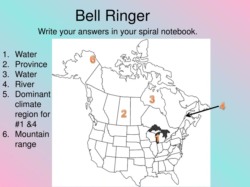
Bell Ringer Write your answers in your spiral notebook. • Water • Province • Water • River • Dominant climate region for #1 &4 • Mountain range 6 3 4 2 1
‘Regions Map’ West Northern Canada Midwest Prairies Northeast Get out your maps. Check your North America Political Map (Regions Map) Mountains and the West East Coast Southeast Southwest Central Canada/ Canadian Shield
Regional Division World regions are sub-divided internally to help study and understand the way they work Regions are divided up by proximity, climate, economy, agriculture, and cultural concentration. Types of Region Formal Functional Perceptual
West Midwest Northeast Sub-regions of the United States Southeast Southwest
Northern Canada Prairies Sub-regions of Canada Mountains and the West East Coast Central Canada/ Canadian Shield
Belt Regions Often times the regions are referred to as ‘Belt Regions’ since they follow lines of latitude Belt regions are mostly perceptual and functional
Sun Belt • Southern states • hot weather • 37th and 38th parallels • economy =agriculture & tourism
Bible Belt • Southeastern and mid-western states • strict religious beliefs • Christianity
Produces much of the world's grain and soybeans Grain Belt/ America’s Breadbasket
Majority of the nation’s corn produced here. • Corn and popcorn • Sweeteners • Ethanol gas Corn Belt
Virginia to the midwest • California Cotton Belt
Rust Belt • Aka: Manufacturing Belt • heavy industry, manufacturing, and associated industries.
Other Belt Regions • Frost Belt- area that is extremely cold and prone to frost • Stroke Belt- higher incidence of strokes • Salt Belt- produces salt in mass quantities
Other Belt Regions • Tornado Alley- area of high risk for tornadoes • Silicon Valley- industrial region of Southern California, foundation point of many tech companies • Mormon Corridor- more people practicing the teachings of the Church of Latter Day Saints
Bilingual Belt • English and French
Canadian Shield • Large geographic shield of land • Continental plate
French Canada • aligns with France • French colonies • identity struggle • separatism
Activity • Be sure you have all of the regions filled out. • Regions Map • Color the different directional regions of the US and Canada and label them. On the back, list three characteristics of each region. • Belt Regions Map • Color the different belt regions of the US and Canada and label them.
________ ________ ________ ________ ________ ________
Where in the World? • Parliament Hill • Ottawa, Ontario, Canada • British • Originally built to house the British Parliament in Canada. After Canada gained its independence the British let Canada claim it for its own use (since technically its still part of Canada). This particular building was erected in 1876.
Talk About It Read the quote below, then think about everything you know about the population density and history of the United States. Although mountains may guide migrations, the plains are the regions where people dwell in greatest numbers. • Ellsworth Huntington (Geography Professor at Yale University) In two complete sentences detail whether you think Ellsworth is correct in terms of population today.
Thinking Look at this ‘Belt’ Region map. Choose three regions that are on this map and explain why you think they are considered important to the United States in terms of culture and economy. • You may not do Bible, Corn, Rust, or Megalopolis