Download
1 / 19
200 likes | 375 Views
Crustal deformation associated with the Mw7.2 2010 El Mayor- Cucapah earthquake from GPS geodesy. 2011 SCEC Annual Meeting Joshua Spinler, Richard Bennett, Javier Gonzalez-Garcia, and Chris Walls. Outline. Photo taken by John Fletcher, CICESE. GPS Data Processing Time series analysis

E N D
Crustal deformation associated with the Mw7.2 2010 El Mayor-Cucapah earthquake from GPS geodesy 2011 SCEC Annual Meeting Joshua Spinler, Richard Bennett, Javier Gonzalez-Garcia, and Chris Walls
Outline Photo taken by John Fletcher, CICESE • GPS Data Processing • Time series analysis • Deformation associated with the M7.2 El Mayor-Cucapah and M5.7 Southern California earthquakes of 2010 • New PBO-Mexico CGPS network PBO Site PLTX
Southern California CGPS • 102 CGPS sites located within 250 km of EMC earthquake • Sites part of both PBO and SCIGN CGPS Networks • Seismicity for period 4/4/2011 – 6/15/2011 (from E. Hauksson)
Time Series Analysis M5.7 Southern California EQ M7.2 El Mayor Cucapah EQ
Time Series Analysis M5.7 Southern California EQ M7.2 El Mayor Cucapah EQ
Time Series Analysis • Constrained Random Search method • Brachetti et al. 1997, Journal of Global Optimization • Finds the minimum of a multi-variable function • Simultaneously solve for 22 different parameters using an exponential decay function • Parameters: Initial offset, Velocity, Annual and Semi-annual perturbations, Coseismic displacement, Postseismic deformation, exponential decay time • Minimize misfit to the horizontal coordinate time series data (NRMS)
Time Series Analysis – Site P481 NRMS = 0.68
Time Series Analysis – Site P494 Mean NRMS for all sites = 0.76 NRMS (P494) = 1.20
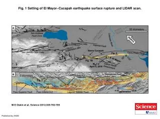
Coseismic displacement April 4, 2010 M7.2 El Mayor-Cucapah
Coseismic displacement June 15, 2010 M5.7 Southern California
Exponential Decay Time • Mean decay time (EMC) = 629 ± 75 days • Mean decay time (SoCal) = 682 ± 67 days • Viscosity (η) = τμ = 1.6 x 10¹⁸ Pa-s • Relatively weak lower crust and/or upper mantle
Conclusions Using the CRS method allows for detailed analysis of complicated GPS coordinate time series data Future work: Fault slip modeling and analysis of postseismic deformation signal Include campaign GPS spanning the earthquakes from northern Baja
PBO in Baja California • Locations for sites strategically chosen to best resolve postseismic deformation patterns and lower crustal/upper mantle rheology
PBO in Baja California Site PLPX Installed 10/27/10
PBO in Baja California Site PALX Installed 9/2/10
PBO in Baja California Installed 4/27/11 Installed 2/11/11 Installed 10/29/10 Installed 8/30/10
Seven new CGPS sites installed in northern Baja California, Mexico, and the data is available online at www.unavco.org Funding for these projects provided by NSF and SCEC