Download
1 / 3
30 likes | 99 Views
Discover the unique interflow zones in the Columbia River basalt layers and the natural spring at Canniwai Creek. Learn about the geological features at BLM Boat Launch and Pacific Lake.

E N D
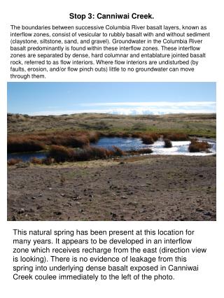
Stop 3: Canniwai Creek. The boundaries between successive Columbia River basalt layers, known as interflow zones, consist of vesicular to rubbly basalt with and without sediment (claystone, siltstone, sand, and gravel). Groundwater in the Columbia River basalt predominantly is found within these interflow zones. These interflow zones are separated by dense, hard columnar and entablature jointed basalt rock, referred to as flow interiors. Where flow interiors are undisturbed (by faults, erosion, and/or flow pinch outs) little to no groundwater can move through them. This natural spring has been present at this location for many years. It appears to be developed in an interflow zone which receives recharge from the east (direction view is looking). There is no evidence of leakage from this spring into underlying dense basalt exposed in Canniwai Creek coulee immediately to the left of the photo.
Stop 4: BLM Boat Launch at Pacific Lake Pacific Lake, part of the Lake Creek system, is currently dry. The lake occupied a Pleistocene Cataclysmic Flood eroded coulee cut into the Roza Member of the Wanapum Basalt. Eyewitness reports indicate Pacific Creek is predominantly filled by surface run-off coming down Lake Creek from the north. A few small springs located in the lake also may contribute some water to the lake when the springs are active. High water line in Pacific Lake. View from BLM boat launch looking towards the south end of Pacific Lake. The top of the Grande Ronde Basalt may only lie within a few tens to 200 feet below the bottom of the coulee. The thickness of the coulee filling sediments in the lake is not known.
Stop 5. Pacific Lake Private Boat Launch Two views into Pacific Lake. The upper view shows the high water line, and the now high and dry private boat launch. The lower view looks into Pacific Lake from the north. The arrow points to the location of the private boat launch.