Download
1 / 30
300 likes | 494 Views
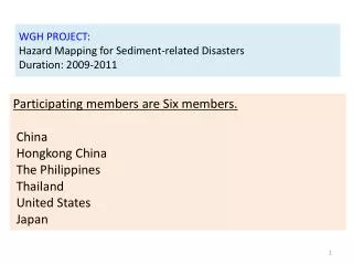
WGH PROJECT: Hazard Mapping for Sediment-related Disasters Duration: 2009-2011. Participating members are Six members. China Hongkong China The Philippines Thailand United States Japan. Collaboration meeting between WGDRR and WGH and Field Training

E N D
WGH PROJECT:Hazard Mapping for Sediment-related DisastersDuration: 2009-2011 Participating membersare Six members. China Hongkong China The Philippines Thailand United States Japan
Collaboration meeting between WGDRR and WGH and Field Training for “Hazard Mapping for Sediment-related Disaster” Schedule of Field Training September 4 Indoor Lecture for TC members September 5 Field Training for TC members and Local people in model site of Zhuhai city - TC member Group (Hayashi, Miyake Group) Field Training - Local people Group (Hiruma, Kamoto Group) Indoor Lecture and Field Training
Road map • 1st year (2009) • Japan will distribute a draft of guideline and opens THD. • Members select model sites. • 2nd year (2010) • Field training • Members draw hazardous area in the model sites. • Discuss technical problems at WS. • 3rd year (2011) • Members make Hazard map that will register in the guideline to reduce damage of sediment‐related disaster. • Publish the guidelineto reduce damage of sediment-related disaster and to spread Japanese technique inTyphoon Committee Region.
Strategy for reducing sediment-related disaster riskCase study in Japan - Land-use restriction Gorge Hazard (Debris flow) -Land use control- Sediment disaster warning information Check dam -Early warning Houses Non-structural measure(Sediment Disaster Prevention Law) - Check dam construction – Structural measure (Sabo Law)
Proposes of Hazard Map are • Land use restrict • To Inform Early Warning Information forresidents who live in hazardous area to evacuate ② Inform Early Warning Information forresidents who live in hazardous area ①Early Warning ③Evacuation
In hazardous Area, • There is possibility that residents die. • It is necessary to evacuate. • The direction of debris flow is unknown. • Debris flow doesn’t spread all Hazardous area. 60°
What’s Hazard Map? Map which guides residents to evacuate safely ② Inform Early Warning Information forresidents who live in hazardous area ①Early Warning ③Evacuation • Hazard Map guides • residents to evacuate safely • Essential information • - Hazardous Area • Evacuation route, refuge • - Explanation about risk
Japanese example 1 (Photo ver.) Hazardous Area Evacuation route and refuge Explanation about risk
Example of Hazard Map: ○○ village Hazard map for sediment-related disaster Refuge: Elementary School Evacuation route Notice: Yellow zone is a high risk area for debris flow. If It has inexperienced heavy rain, be careful and evacuate. 100m
September 5 Field Training for TC members and Local people model site of Zhuhai city
Example of Hazard Map: ○○ village Hazard map for sediment-related disaster route which we walked Refuge: Elementary School ⑤ ④ ① ② ③ Evacuation route Notice: Yellow zone is a high risk area for debris flow. If It has inexperienced heavy rain, be careful and evacuate. 100m
1. Finding Valley-type topography 2. Setting the direction of debris flow and make longitudinal section
1. Finding Valley-type topography ① 2. Setting the direction of debris flow and make longitudinal section
3.Measure gradient of stream and identify the point of that become 10 degree = Flooding beginning point 2 degree = the end of warning area 10 degree 2 degree
3.Measure gradient of stream and identify the point of that become 10 degree = Flooding beginning point ②
③ 2 degree = the end of warning area 4. Draw warning area with watching 5m above riverbed in several points above5m (image)
Refuge ⑤
1. When to escape? Be aware to rainfall - Caution from Meteorological Bureau > Announcement by TV, Web, etc. - Measure rainfall by yourself > Simple tools also useful Example of simple tool made by plastic bottle to measure rainfall ****Important**** If you feel “Unusual rainfall!!”, Don’t hesitate to evacuate!!!
2. Escape from what? where to escape? ○○ village Hazard map for sediment-related disaster Hazard Map - what type of phenomena? - how wide it spread? - where to escape? Refuge: Elementary School Evacuation route Notice: Yellow zone is a high risk area for debris flow. If It has inexperienced heavy rain, be careful and evacuate. 100m
3. How to be able to escape?(Preparedness in usual) Japanese example of evacuation drill in every June 3.1 Governmental Officers • Who will decide evacuation recommendation to residents? • How to announce evacuation recommendation to residents? • How to manage shelter operation? Drill for sediment disaster by city officers Drill to distribute foods and drink for evacuees
3. How to be able to escape?(Preparedness in usual) Japanese example of evacuation drill in every June 3.2 Residents • Who will take aged people and handicapped people to shelters? >cooperation in community • How to keep aware to disasters? >hold seminars, evacuation drill Drill to take aged people and handicapped people to shelters To make handmade hazard map by residents
Road map • 1st year (2009) • Japan will distribute a draft of guideline and opens THD. • Members select model sites. • 2nd year (2010) • Field training • Members draw hazardous area in the model sites. • Discuss technical problems at WS. • 3rd year (2011) • Members make Hazard map that will register in the guideline to reduce damage of sediment‐related disaster. • Publish the guidelineto reduce damage of sediment-related disaster and to spread Japanese technique inTyphoon Committee Region.
Example of Hazard Map: ○○ village Hazard map for sediment-related disaster Refuge: Elementary School Evacuation route Notice: Yellow zone is a high risk area for debris flow. If It has inexperienced heavy rain, be careful and evacuate. 100m
Participating members select model site. Ex. 1) HongKong China Debris Flow Slope failure
Ex. 2) United States Ex. 3) Thailand Slope failure Debris Flow Model site Model site 1 Model site 2 • Participating members will draw hazardous area in the model sites. • Participating members will make hazard map.