Download
1 / 41
420 likes | 557 Views
This article delves into the hydrologic cycle and the critical role of aquifers in water storage and transmission. It defines key concepts like hydraulic conductivity and Darcy's Law, explaining how materials transmit water. We will examine the challenges of groundwater withdrawal, focusing on the High Plains Aquifer, which significantly impacts U.S. irrigation. Further, it discusses land subsidence issues in areas like Venice and California's Central Valley. Lastly, specific groundwater usage patterns in Tennessee highlight the importance of aquifers in supporting local populations.

E N D
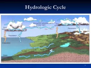
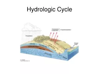
Aquifer—a body of rock or sediment that stores, filters, and transmits water through pore spaces and openings in the rocks
Henri Darcy, Dijon, France, 1855 Defined the term “hydraulic conductivity” to mean the ease with which a material transmits water.
Darcy’s Law: Q K = AI K = hydraulic conductivity (m/day) I = hydraulic gradient (m/m) A = cross-sectional area (m2) Q = discharge (m3/day)
Problems with groundwater withdrawal: • Overdraft—occurs when withdrawal from • wells + natural discharge > recharge
High Plains (Ogallala) Aquifer
30 % of all groundwater withdrawn in US is taken from High Plains Aquifer, mostly for irrigation Center pivot irrigation
Ogallala-- groundwater withdrawals for agriculture: 14 bgd 5.5% of 0.2% of total water withdrawals: 0.78 bgd groundwater withdrawals: 0.03 bgd Tennessee
Changes in the water table level in the Ogallala (1890-1999): • 1900-1980—avg. water table • decline: 10 ft (max. 175 ft) • 1980-2000— water table decline has • slowed due to regulations • and more efficient irrigation • techniques MAP of Changes in Ogallala
2. Land subsidence • lowering of land surface due to • groundwater withdrawal
Venice, Italy— land subsidence, coastal flooding
Central Valley, Calif.— land subsidence
Mexico City
abaondoned well casing, Mexico City
Special problems with groundwater: Karst—terrain having unique characteristics of relief and drainage due to dissolution of carbonate rocks (limestone, dolomite)
landfill cave stream Karst aquifers are typically not good filters of groundwater pollutants
Winterpark, FL “Oh no, my truck!”
Groundwater withdrawals and uses in the US (2000) million gallons Use per day (bgd) % Irrigation 56.9 69 Public supply 16.0 19 Industry 3.6 4 Other 6.6 8 Total 83.1 100
Fig. 4.2 California, Central Valley and western basin aquifers (10%) High plains aquifer (30%) Miss. R. aquifers (15%)
Water resources of Tennessee % Tennesseans that rely on public water 1960……68% 1995….. 84% TN -- Total water withdrawals: Surface water (rivers, reservoirs): 96% Groundwater: 4%
East TN: some high-producing aquifers in areas of fractured bedrock Middle TN: poor aquifers due to low-porosity, dense limestone bedrock West TN: very productive aquifers, sand and gravel deposits
Note high withdrawals from TVA reservoirs. These supply major cities and provide water for steam plants.