Download
1 / 10
100 likes | 222 Views
The FEWS Flood Risk Monitoring Model From Rain to Rivers. Tanya Hoogerwerf Thursday, February 22, 2001. FEWS Model. Provides a continuous simulation of stream flow, on a daily time step, for nearly 3,000 basins on the African continent. Rainfall/runoff simulation model containing…

E N D
The FEWS Flood Risk Monitoring ModelFrom Rain to Rivers Tanya Hoogerwerf Thursday, February 22, 2001
FEWS Model • Provides a continuous simulation of stream flow, on a daily time step, for nearly 3,000 basins on the African continent. • Rainfall/runoff simulation model containing… • a soil water accounting module that produces surface and sub-surface runoff for each sub-basin • an upland headwater basins routing module • and a major river routing module.
Runoff Producing Mechanisms • Surface runoff due to precipitation excess (including direct runoff from impermeable areas of the basin) • Rapid Subsurface Flow (interflow), and • Base Flow
Soil Water Accounting Module (SAC-SMA) Revisited FEWS: Active Zone (2 layers) & Groundwater Zone (1 layer) Active Layer Baseflow
Runoff Calculations • The HYDRO1K data provide basin boundaries and stream networks that form the spatial framework of the model. • The FAO soil map provides characterization of the hydraulic properties of the earth's surface that are required to compute the water balance within a basin. • The NOAA RFE provide the estimates of gross precipitation input to each basin.
Total Channel Inflow (SAC-SMA) uT = Channel Inflow from SWC= Surface Runoff + Base Flow Runoff Surface Runoff = f(Precipitation, Soil Water Content, SR Gen.) Base Flow Runoff = f(BF Recession Rate, SWC, BF Lost to Aquifers) Water Balance Relationship for Each Reach: dSidt = Ui-1 + pi*uT – Ui S=Water Volume Pi = Fraction of Total Water Inflow Corresponding to Reach i Ui = Reach i Ui-1 = Upstream Inflow from Reach i-1
Time of Concentration Grid • Slope, flow direction, and flow accumulation grids of the HYDRO1K • Manning equation for flow in an open channel • Units: 1/10 day
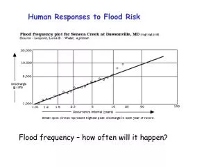
Rainfall • NOAA has produced RFE images (Herman et al., 1997) on a dekadal (10-day) time step • Basin Excess Rainfall Maps (BERM) Produced
Output Mozambique Flood Information Stream Flow Model Flood Risk Map Page (select Pfafstetter Basin)
USGS/EROS Data Center http://edcsnw3.cr.usgs.gov/ip/gflood/ Riverside Technology Real-Time Prediction for Flood Warning and Management- Georgakakos 1995 Coupled Rainfall-Flow Forecasting Models- Georgakakos References