Download
1 / 42
420 likes | 613 Views
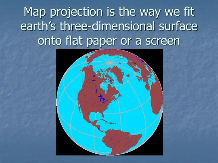
Map projection is the way we fit earth’s three-dimensional surface onto flat paper or a screen. On a map, when lines of latitude and longitude cross what is the resulting angle?. Pencils Down – The following information is for background knowledge only. Map Projections.

E N D
Map projection is the way we fit earth’s three-dimensional surface onto flat paper or a screen
On a map, when lines of latitude and longitude cross what is the resulting angle?
Pencils Down – The following information is for background knowledge only.
Map Projections • Think of an transparent globe w/ an imagined light source inside • What type of shadow would be cast?
Shadow cast would depend on light location… • Gnomonic – light source at center • Stereographic – light at point opposite of tangent of globe meeting map • Orthographic – light source at infinity
Onto What do you project • An azimuth is the angle formed at the beginning point of a straight line, in relation to the meridian
The Math… Just Kidding • Derivation of the Projection: • cosφ=dR⇒d=Rcosφ • cosλ=p2d⇒p2=dcosλ=Rcosφcosλ • sinλ=p1d⇒p1=dsinλ=Rcosφsinλ • Derivation of the Inverse: • d=∥p∥ • cosλ=p2∥p∥⇒λ=cos-1(p2∥p∥) • cosφ=dR⇒φ=cos-1(∥p∥R)
The Most Common: • Conformal (i.e., angles are preserved) • Equal Area (i.e., areas are in constant proportion) • Equidistant (i.e., distances are in constant proportion) • An Important Mathematical Result: • A single projection can not be both conformal and equal area
Three sources of map distortion • Map scale – most maps are smaller than the reality they represent. Map scales tell us how much smaller. • Map projection – this occurs because you must transform the curved surface of the earth on a flat plane. • Map type – you can display the same information on different types of maps.
Mercator Projection • Stretches the poles from one length to the size of the equator. The north-south scale is constant, but east-west scale increases to twice the north-south scale at 60 degrees N and infinitely at the poles. • Shapes are correct for all areas, and map has correct directional relationships. • Look at the size of Greenland and Antarctica. • Map exaggerates the distance between Chicago and Stockholm, both in northern latitudes. • Created in 1569
Equal Area Projection • Represents areas correctly, but distorts shapes. • If South America is 8 times larger than Greenland on the globe, it will be 8 times bigger on the map.
Robinson Projection • Frequently used. • Distorts both size and shape, but not too much. • The major benefit of the Robinson projection is that oceans are uninterrupted. This projection is useful in depicting patterns of global interaction. • Considered a compromise projection
Goode’s projection interrupts the oceans and tucks Australia and New Zealand farther west than in reality. Therefore, land masses appear relatively large compared to the oceans. • Minimized distortion in the shape of the various land masses and the size of one land mass compared to other land masses.
The Peters Projection World Map is one of the most stimulating, and controversial, images of the world. When this map was first introduced by historian and cartographer Dr. Arno Peters at a Press Conference in Germany in 1974 it generated a firestorm of debate. The first English-version of the map was published in 1983, and it continues to have passionate fans as well as staunch detractors.The earth is round. The challenge of any world map is to represent a round earth on a flat surface. There are literally thousands of map projections. Each has certain strengths and corresponding weaknesses. Choosing among them is an exercise in values clarification: you have to decide what's important to you. That is generally determined by the way you intend to use the map. The Peters Projection is an area accurate map. • http://www.petersmap.com/page2.html
B A C D
B A D C Equal Area Projection On which map is the size of Greenland distorted the most?
B A D C Equal Area Projection Which map is best for navigation?
B A D C Equal Area Projection Which map best corrects most of the distortions associated with map projection?
Mercator Projection What is bad about this projection? a. Shape b. Size c. Distance d. direction
What is bad about this projection? • a. Shape • b. Size • c. Distance • direction Equal Area Projection • What is best about this projection? • a. Shape b. Size • c. Distance d. direction
Map projections attempt to correct for errors in a. transferability b. relative size, distance, scale & proportion c. relative size, distance, shape, & direction d. distance, proximity, and topology e. distance, shape, and lines of latitude and longitude • The Mercator projection preserves a. size b. area c. shape d. scale e. distance
Goode’s Projection • What is bad about this projection? • Shape b. Size • c. Distance d. direction