Download
1 / 11
110 likes | 215 Views
Intro to Maps Global Studies Mr. McRoberts 7.3.1 Formulate a broad understanding of the location of countries of Africa, Asia and the southwest Pacific

E N D
Intro to Maps Global Studies Mr. McRoberts 7.3.1 Formulate a broad understanding of the location of countries of Africa, Asia and the southwest Pacific 7.3.2 Formulate a broad understanding of the location of capital cities in Africa, Asia and the southwest Pacific using longitude and latitude on maps and with locational technology such as GPS and GIS
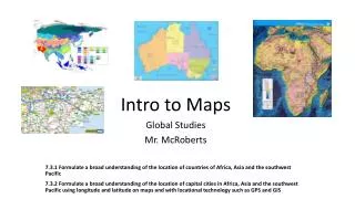
What is a map? • A map is a picture showing relationships between elements of space, such as objects, regions, and themes. What kind of maps can we use? • Political • Physical • Thematic • Mobility
Who makes maps? • The study and practice of mapmaking is called: cartography • A person who makes maps is called a: cartographer
What can be found on a map? Every map should include: • Title Tells us what information the map is giving • Compass Tells us what direction to look on the map • Legend Tells us what the pictures and items on the map are • Scale Tells us the ratio of a distance on the map to the same distance on the ground
Political Maps • The purpose of a political map is to show territorial borders, capitals, and cities.
Physical Maps • The purpose of physical maps is to show land and water forms such as mountains, rivers, lakes, and forests.
Thematic Maps • The purpose of a thematic map is to show a particular theme connected with a specific geographic area. Examples: Climate maps, Population Density maps, Electoral College maps, etc. Climate Map Population Density Map Electoral College Map
Mobility Map • A mobility map, or road map, is a map that primarily displays roads and transport links rather than natural geographical information. (Think of a road atlas or a map giving you directions)
Treasure Map • Arrgh, it helps you find the treasure…
Google Maps Activity Google Maps gives a great example of political, physical, and mobility maps. Search around the world for different locations and remember to use the map view, satellite view, and street view for interesting looks at the world around us. Be sure to zoom in and out to get good looks at each map. Try searching the following locations: • Center Grove Middle School North • Lucas Oil Stadium, Indianapolis, IN • Statue of Liberty, New York City, NY • Area 51, Nevada, USA (can you find it?) • Your home or favorite local spot • Sydney Opera House, Sydney, Australia • Eiffel Tower, Paris, France • The Great Wall of China • The Great Pyramids of Giza, Egypt