Download
1 / 14
140 likes | 162 Views
Explore the relationships between corrected PLMR data, geological effects, soil landscape, and future directions in the Livingstone Creek study. Discover insights on scaling information to satellites and improving water balance estimates for Kyeamba through remote sensing technologies.

E N D
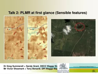
Talk 2: PLMR at first glance (Sensible features) Dr Greg Summerell + Sandy Grant. DECC Wagga Wagga NSW Mr Victor Shoemark + Tony Benardi. DPI Wagga Wagga NSW
NAFE Flights Livingstone Creek (Example of continuos soil moisture data for November 06) Manual field measurement
Corrected PLMR data 13/11/2006 20/11/2006 30/10/2006 6/11/2006
Differences in the Livingstone and Lloyd meta-sediment soil landscape Livingstone Lloyd
Future directions • Correlation between 5cm – rest of profile? (Current thoughts, during extreme dry times maybe 5cm soil moisture not related to rest of profile, what are the implications of this?) • Does the Influence of Geology/Soil landscape/Position in landscape provide a rule set for scaling information up to satellites. • Correlation between measured Evapotranspiration and satellite estimates. • Workup a catchment water balance for Kyeamba improving estimates through remote sensing technologies