Download
1 / 1
10 likes | 188 Views
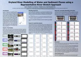
Dryland River Modelling of Water and Sediment Fluxes using a Representative River Stretch Approach. Badland Area. WITHOUT DEGRADATION. WITH DEGRADATION. Time [hours]. FLOW VELOCITY. MAX. SEDIMENT CONC. SEDIMENT OUTFLOW. DEPOSITION. River length [km].

E N D
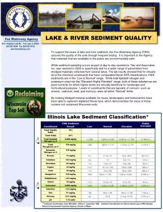
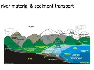
Dryland River Modelling of Water and Sediment Fluxes using a Representative River Stretch Approach Badland Area WITHOUT DEGRADATION WITH DEGRADATION Time [hours] FLOW VELOCITY MAX. SEDIMENT CONC. SEDIMENT OUTFLOW DEPOSITION River length [km] • Eva N. Mueller (1), Ramon J. Batalla (2,3), Axel Bronstert (1) • Institute of Geoecology, University of Potsdam, Postfach 60 15 53, 14415 Potsdam, Germany (2) Department of Environmental and Soil Sciences, University of Lleida, 25918 Lleida, Spain(3) Forest Technology Centre of Catalonia, Pujada del Seminari, 25280 Solsona, Spain (enmue@uni-potsdam.de) Introduction The study investigates process-based modelling of sediment transport of a Mediterranean mountainous dryland river within the meso-scale Isabena watershed (445 km2) of the Pre-Pyrenean region in NE Spain. The modelling study is carried out to enable the quantification of sediment fluxes that erode mainly from local badland areas during high-intensity rainstorm events, resulting in high-density sediment fluxes in the river system and severe sedimentation of a downstream reservoir thus threatening future water supply (see map). The transport of sediments from the badland areas in the river’s main stem was modelled using a composition of five representative river stretches. The proposed modelling framework enabled a detailed spatial and temporal examination of complex deposition and river bed degradation patterns as well as an insight into the temporary sediment storage behaviour of the riverbed and of its floodplain along the entire river flow path. Central research questions are: (1) how to parameterise heterogeneous river sections at the meso-scale, (2) how sensitive are the model parameters of the sediment routine to high or low flow conditions, (3) how to model the complex processes of temporary storage and re-degradation of fine sediments in the riverbed? Modelling Approach The water routing is based on the kinematic wave approximation after Muskingum. Flow rate, velocity and flow depth are calculated for each river stretch and an hourly time step using Manning’s flow equation. Sediment transport is modelled using the transport capacity concept based on a power function of the stream velocity as implemented e.g. in the SWAT model. The maximum concentration of suspended sediment that can be transported by the water is given by: Concmax = a · v b where v is the flow velocity in (m/s), Concmax is the maximum sediment concentration for each river stretch in (ton/m3), and a and b are user-defined coefficients. Riverbed degradation is calculated by: SedDegradation = (Concmax – Conccurrent) · V· C· E where Conccurrent is the sediment concentration at the current time step (ton/m3), V is the volume of water in the reach segment (m3), C is the channel cover factor (-) and E is the channel erodibility factor (-). Result III. Composite Modelling of the River The Isabena River downstream of the badland area was modelled as a composite of characteristic stretches along a 32.9 km stemusing measured time series of water discharge from the year 2000 with an hourly time step as input data. As no data for sediment discharge was available, a hypothetical scenario was assumed with a constant sediment input of 50 g/l occurring when the daily rainfall amount exceeds 20 mm. The graphics below show the water and sediment fluxes for no degradation on the left size and full re-degradation of deposited sediments on the right side. Time [hours] Result II: Sensitivity Analysis Critical model input parameters are: the Manning‘s roughness factor, slope, shape of cross-section, channel cover factor, the a and b parameters of the power function and the erodibility factor of the riverbed. The first four parameters were derived from the field data for the five representative river stretch types. A sensitivity analysis was carried out to investigate the influence of the power function parameters with a having a literature reference range of 0.01 – 0.0001and b between 1.0-1.5.The first two columns below show the flow velocity and the corresponding maximum sediment concentrations at maximal transport capacity as a function of discharge for the five characteristic river types. The other two columns depict the corresponding sediment discharge out of and the deposition inside a reach for a model scenario with a hypothetical incoming sediment concentration of 50 g/l. The circles Oshow the model results for a parameter set of (a, b) = (1.7, 0.016), that were derived from a limited data set on water and sediment discharge data for the Isabena River. The uncertainties associated with the right choice of the a and b parameters are considerable, more pronounced for the steep, upslope stretches, and increase over proportionally for larger water discharge. Result I: Field Studies The Isabena River is characterised by a very heterogeneous spatial distribution of river forms and properties, which makes the parameterisation of state-of-the-art river models a difficult task. Steep, narrow, deep incised mountain torrents with rocky, gravely riverbeds in the upper parts of the catchment alternate with shallow, plain and very wide riverbeds and large floodplains with silty riverbed materials in the lower catchment area, with parts of the river system having an ephemeral flow regime. To enable model parameterisation, five representative river stretches were derived from the results of a field campaign that investigated central model parameters such as the cross-sectional profile, slope, roughness and the gradation of the riverbed material. Type A steep, narrow Slope: 3 % Manning: 0.02 River length [km] Type B steep, deep, wide Slope: 2 % Manning: 0.02 • Discussion • The river data of the field study led to the derivation of five distinct types of river sections that enabled the identification of key model parameters which adequately describe the intrinsic heterogeneity of the mountainous drylandat the meso-scale. • The sensitivity analysis showed that the uncertainty in regard to the model parameters of the transport capacity equation is enormous. It thus appears unfeasible to use the modelling approach for ungauged rivers. It is furthermore questionable to which extent measured data from a specific type of river section can be used for the parameterisation of another river section type. • Temporary storage of sediments in the riverbed appears to play an important role for the sediment export out of the river system. For the model scenario without degradation, a large amount of sediments is deposited within the entire river stem and does not reach the outlet. For the scenario with degradation, a large amount of the sediment is temporarily stored preferably in the shallow river stretches with large floodplains, and remobilised during small floods several days after the main flood event. The rather crude model approach thus enabled the reproduction of complex, highly non-linear transport processes along the river. Type C medium, regular Slope: 1.3 % Manning: 0.03 Type D shallow, wide Slope: 0.75 % Manning: 0.02 Type E shallow, narrow Slope: 0.75 % Manning: 0.04 Acknowledgements This research was carried out within the SESAM (Sediment Export from Semi-Arid Catchments: Measurement and Modelling) project and was funded by the Deutsche Forschungsgemeinschaft.