Download
1 / 36
360 likes | 498 Views
Overview of the NRC Decadal Review. Dennis P. Lettenmaier Department of Civil and Environmental Engineering University of Washington for presentation at workshop on Polar Snowfall Hydrology Mission Planning Meeting McGill University June 26, 2007. Organization of Study.

E N D
Overview of the NRC Decadal Review Dennis P. Lettenmaier Department of Civil and Environmental Engineering University of Washington for presentation at workshop on Polar Snowfall Hydrology Mission Planning Meeting McGill University June 26, 2007
Organization of Study • Executive Committee (18 members) • Seven Thematically-Organized Panels • Earth Science Applications and Societal Needs • Land-use Change, Ecosystem Dynamics and Biodiversity • Weather (incl. space weather and chemical weather) • Climate Variability and Change • Water Resources and the Global Hydrologic Cycle • Human Health and Security • Solid-Earth Hazards, Resources and Dynamics
Executive Committee • Rick Anthes, UCAR, co-chair, atmospheric science • Berrien Moore, U. New Hampshire, co-chair, biogeochemical cycling • Jim Anderson, Harvard, atmospheric science, chemistry • Bruce Marcus, TRW (ret), remote sensing • Bill Gail, Ball Microsoft Virtual Earth, civil space and IT • Susan Cutter, U. South Carolina, hazards and risk • Tony Hollingsworth, ECMWF, weather forecasting • Kathie Kelly, U. Washington, physical oceanography/satellite obs • Neal Lane, Rice, policy • Warren Washington, NCAR, climate • Mary Lou Zoback, RMS, solid earth Panel Chairs • Tony Janetos, PNL/U. Md., ecology and land remote sensing • Brad Hagar, MIT, solid earth • Ruth DeFries, U. Maryland, land cover change and remote sensing • Susan Avery, CIRES and CU, meteorology, space weather • Eric Barron, U. Texas, climate, paleoclimate • Dennis Lettenmaier, U. Washington, hydrology • Mark Wilson, U. Michigan, infectious disease and remote sensing
Charge to Panels • Identify needs and opportunities for observations from space to advance Earth science and applications for the next decade and beyond; • Propose programs or missions to meet these needs and opportunities, in priority order; • Describe each proposed mission in terms of • Contributions to science and applications • How it meets prioritization criteria • Benefits to society • Technical aspects • Schedule • Costs 4. Briefly identify needs for obs that are needed to complement space-based obs 5. Identify essential other components (telemetry, data processing, management and stewardship)
Criteria for Prioritization • Contributes to the most important scientific questions facing Earth sciences today (scientific merit-discovery, exploration); • Contributes to applications and policy making (societal benefits); • Contributes to long-term observational record of the Earth; • Complements other observational systems, including national and international plans; • Affordable (cost considerations, either total costs for mission or costs per year); • Degree of readiness (technical, resources, people); • Risk mitigation and strategic redundancy (backup of other critical systems); • Makes a significant contribution to more than one thematic application or scientific discipline. Above not in priority order
FINAL REPORT • Recommends a Path Forward that Restores US Leadership in Earth Science and Applications and averts the Potential Collapse of the System of Environmental Satellites • Presents an Integrated Suite of Missions • Panel recommendations rolled-up • Missions sequenced • Overall cost matched to anticipated resources plus reasonable growth • Highest Priorities of Each Panel Preserved • Some Guidance on How To Handle Budget or Technology Development Problems
KEY AGENCY RECOMMENDATIONS(for currently planned observing system) • NASA-continuity of precipitation and land cover • Launching GPM by 2012 • Obtaining a replacement to Landsat 7 data before 2012. • The committee also recommends that NASA continue to seek cost-effective, innovative means for obtaining land cover change information.
MAIN RECOMMENDATION(for next decade) • NOAA and NASA should undertake a set of 17 recommended missions, phased over the next decade
SWOT Launch 2013-2016 GRACE-II Launch 2016-2020 Changes in aquifers and deep ocean currents River discharge estimates SCLP Launch 2016-2020 Snow pack accumulation and Snowmelt extent Snow water equivalent, snow depth, and snow wetness GPSRO Launch 2010-2013 Pressure/ temperature/ water vapor profiles PATH Launch 2016-2020 Dynamics of water storage in seasonal snow packs Societal Challenge:Freshwater Availability Improved precipitation and drought forecasts to improve water resource management Temperature and humidity profiles
SMAP Launch 2010-2013 Linkage between terrestrial water, energy, and carbon cycle ACE Launch 2013-2016 Cloud and aerosol height 3D-Winds Launch 2020+ Three dimensional tropospheric wind profiles PATH Launch 2016-2020 Temperature and humidity profiles XOVWM Launch 2013-2016 High resolution ocean vector winds GPSRO Launch 2010-2013 Pressure/ temperature/ water vapor profiles Hurricane wind fields Societal Challenge:Improved Weather Prediction Longer-term, more reliable weather forecasts Sea surface temperature
XOVWM Launch 2013-2016 SWOT Launch 2013-2016 Sea level measurements extended into coastal zones High resolution ocean vector winds LIST Launch 2016-2020 Global high resolution topography SCLP Launch 2016-2020 Snow pack accumulation and Snowmelt extent Ocean eddies and currents Detection of active faults DESDynI Launch 2010-2013 Changes in Earth’s surface and movement of magma Nutrients and water status of vegetation, soil type and health HyspIRI Launch 2013-2016 PATH Launch 2016-2020 3D-Winds Launch 2020+ Temperature and humidity profiles Three dimensional tropospheric wind profiles Societal Challenge:Extreme Event Warnings Longer-term, more reliable storm track forecasts and intensification predictions, volcanic eruption and landslide warnings to enable effective evacuation planning. Pressure/ temperature/ water vapor profiles Processes indicating volcanic eruption GPSRO Launch 2010-2013 Sea surface temperature Hurricane wind fields
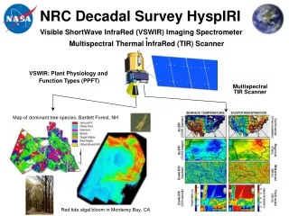
HyspIRI Launch 2013-2016 SWOT Launch 2013-2016 Nutrients and water status of vegetation, soil type and health ASCENDS Launch 2013-2016 CO2 measurements: Day/night, all seasons, all latitudes Ocean eddies and currents Inventory of global CO2 sources and sinks DESDynI Launch 2010-2013 Height and structure of forests GEO-CAPE Launch 2013-2016 Dynamics of coastal ecosystems, river plumes, tidal fronts SMAP Launch 2010-2013 Soil freeze/ thaw state Societal Challenge:Ecosystem Services Improved land use, agricultural, and ocean productivity forecasts to improve planting and harvesting schedules and fisheries management ACE Launch 2013-2016 Organic material in surface ocean layers XOVWM Launch 2013-2016 Improved estimates of coastal upwelling and nutrient availability Soil moisture effect on vegetation
3D-Winds Launch 2020+ Three dimensional tropospheric wind profiles ACE Launch 2013-2016 GEO-CAPE Launch 2013-2016 Identification of human vs. natural sources for aerosols and ozone precursors GACM Launch 2016-2020 Cloud and aerosol height Vertical profile of ozone and key ozone precursors Observation of air pollution transport in North, Central, and South America Global aerosol and air pollution transportation and processes Aerosol and cloud types and properties Societal Challenge:Air Quality More reliable air quality forecasts to enable effective urban pollution management.
XOVWM Launch 2013-2016 High resolution ocean vector winds 3D-Winds Launch 2020+ Three dimensional tropospheric wind profiles PATH Launch 2016-2020 Temperature and humidity profiles GPSRO Launch 2010-2013 SWOT Launch 2013-2016 Hurricane wind fields Pressure/ temperature/ water vapor profiles Ocean eddies and currents Societal Challenge:Improved Extreme Storm Warnings Longer-term, more reliable storm track forecasts and intensification predictions to enable effective evacuation planning Sea surface temperature
PATH Launch 2016-2020 Temperature and humidity profiles SWOT Launch 2013-2016 Ocean eddies and currents SMAP Launch 2010-2013 XOVWM Launch 2013-2016 High resolution ocean vector winds Linkage between terrestrial water, energy, and carbon cycle Sea level measurements extended into coastal zones Sea surface temperature ASCENDS Launch 2013-2016 CO2 measurements: Day/night, all seasons, all latitudes 3D-Winds Launch 2020+ GPSRO Launch 2010-2013 Three dimensional tropospheric wind profiles HyspIRI Launch 2013-2016 Spectra to identify locations of natural resources Pressure/ temperature/ water vapor profiles Societal Challenge:Energy Security Improved energy security through more effective oil and gas exploration, safer extraction through improved marine forecasts, optimized placement of wind farms through measurement of global winds, better energy conservation through improved heating/cooling forecasts, and support of carbon trading and energy policy. Inventory of global CO2 sources and sinks
DESDynI Launch 2010-2013 Changes in carbon storage in vegetation ACE Launch 2013-2016 Aerosol and cloud types and properties ICESat-II Launch 2010-2013 GPSRO Launch 2010-2013 Estimate of flux of low-salinity ice out of Arctic basin Pressure/ temperature/ water vapor profiles ASCENDS Launch 2013-2016 GACM Launch 2016-2020 CO2 measurements: Day/night, all seasons, all latitudes Vertical profile of ozone and key ozone precursors Societal Challenge:Climate Prediction Robust estimates of primary climate forcings for improved climate forecasts, including local predictions of the effects of climate change CLARREO Launch 2010-2013 Absolute spectrally resolved IR radiance Connection between climate and CO2 exchange Incident solar and spectrally resolved reflected irradiance
17 Missions (Red = <$900 M; Green = $300-$600 M; Blue = <$300 M)
[1] Cloud-independent, high temporal resolution, lower accuracy SST to complement, not replace, global operational high-accuracy SST measurement
NASA Earth Science Program: Rapid Return to 2000 Funding Levels Prior Commitments Future Program Decadal Survey $ Million Missions Mission Supporting Year
NASA Earth Science Program: A Substantial Funding Decline Prior Commitments FY08 Request FY06 $ Million Missions Mission Supporting Fiscal Year
So what is the solution a) Testimony to key congressional committees (much of this has already happened) b) University (and other non-governmental) interaction with federal affairs offices/representatives -- Most university researchers don’t know these people -- Need to convey information in a concise “USA Today” form c) Proposed statement from AGU (discussions underway) d) White paper or other response (including position statement) from this meeting e) Concerted action among key universities – possible meeting with congressional staff
AGU position statement on NASA earth and space sciences (May 2005) “AGU calls for the U.S. Administration, Congress, and NASA to continue their commitment to innovative Earth and space science programs. This commitment has placed the U.S. in an international leadership position .. it is, however, threatened by financial demands placed on NASA by … the space shuttle, space station, and the Moon-Mars initiative. … Earth and space sciences have become a lower priority at NASA. NASA's proposed 2006 budget reduces science research by $1.2 billion over the next five years … These cuts will decimate effective programs …. These losses will degrade our weather forecasting, search and rescue, and life and property protection capabilities … NASA is being asked to do more than it can with the resources provided. Shifting financial resources from science threatens vital investments and capabilities …. AGU asks the U.S. Administration, Congress, and NASA to renew their commitment to Earth and space science research.”