Map Projections: Types and Properties
260 likes | 292 Views
Learn about the types and properties of map projections, including conformal, equal area, equidistant, and azimuthal. Explore cylindrical, conical, and planar projections with detailed examples.

Map Projections: Types and Properties
E N D
Presentation Transcript
MAP PROJECTIONS but before let’s review some basic concepts….
Types of Maps • General Purpose • Topographic • Thematic/Choropleth • Dot • Graduated Circle • Isometric/Isolines • Isopleth • Mental Maps
Scale • Small-scale map 1:250, 000 shows less detail of a large area! • Large-scale map 1:50,000 shows more detail of a small area!
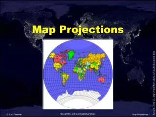
What is a Map Projection? Properties of Map Projections Types of Map Projections MAP PROJECTIONS
What is a Map Projection? • THE ONLY TRUE REPRESENTATION OF EARTH, FREE OF DISTORTION IS A GLOBE. • MAPS ARE FLAT • PROCESS BY WHICH GEOGRAPHIC LOCATIONS (LAT & LONG) ARE TRANSFORMED FROM A 3 - DIMENSIONAL SPHERE TO A 2 - DIMENSIONAL FLAT MAP IS CALLED A PROJECTION
Distortions • EVERY MAP PROJECTION DISTORTS AT LEAST THREE, AND SOMETIMES ALL FOUR, OF THE FOLLOWING PROPERTIES: • SHAPE • AREA • DISTANCE • DIRECTION
Properties of Projections The Cartographer decides on which projection to use depending on which properties of the earth are to be kept in the flat map. The following slides will give you a more detailed idea of these properties which will help you select the best map for your particular purpose.
Properties of Map Projections • CONFORMAL: A CONFORMAL PROJECTION MAINTAINS SHAPE IN SMALL LOCALIZED AREAS • EQUAL AREA: THESE PROJECTIONS SHOW THE AREAS OF ALL REGIONS ON THE MAP IN THE SAME PROPORTION TO THEIR TRUE AREAS ON THE GLOBE. • EQUIDISTANT: NO MAP CAN SHOW DISTANT CORRECTLY BETWEEN ALL POINTS ON A MAP, BUT ONLY FROM ONE, OR AT MOST TWO, POINTS TO ANY OTHER POINT. THIS PROJECTION MAINTAINS DISTANCE. • AZIMUTHAL:THIS PROJECTION CORRECTLY SHOWS DIRECTIONS (AZIMUTHS) FROM A SINGLE POINT TO ALL OTHER POINTS ON A MAP.
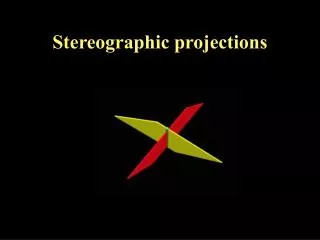
Types of Map Projections Map projections are related to either a cylinder, cone or plane. Imagine a transparent globe with a light in the middle. You can project the globe onto a flat sheet of paper just as a picture is projected on a screen. In this case, because the earth is round, the paper can be rolled into a cylinder, a cone, or a plane. The projection is made, and the paper is unrolled to reveal your map! Even where you place the light source to make the projection becomes an issue. Does the light source go in the middle of the globe (Gnomonic), touching the globe (Stereographic) or off the globe altogether (Orthographic)? So, we have three basic types of map projections: 1. Cylindrical 2. Conical 3. Planar
Conical Projections – The Map Notice: this projection preserves the shape or conformal property
Conical Projections – The Map Notice: this projection preserves the distance property
Summary • A Cartographer decides which map projection to use for his/her purposes. • You chose your projection based on the properties you want to preserve: equidistant – distance preserved conformal – shape preserved • equal area – area preserved • azimuthal – directions are preserved
Summary • You then decide on which type of projection you want. This depends on which area of the earth you want to display and how you want to display it: • Cylindrical – eg. Mercator • Conical – eg. Lambert • Planar – eg. Azimuthal • Each type of projection is associated with many different projections that preserve different properties. They each get their own name.For example, there is a Lambert Conformal Conic AND a Lambert Equidistant Conic
References • Most of the diagrams in this presentation were borrowed from the following website. • Dana, Peter H., “Map Projection Overview”, University of Colorado Boulder. (October, 2000): Online. Internet. Available at http://www.colorado.edu/geography/gcraft/notes/mapproj/mapproj.html