Download
1 / 30
320 likes | 750 Views
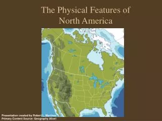
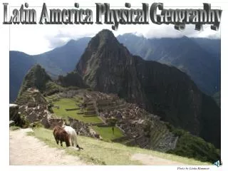
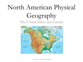
Physical Geography of North America. Ch 5.1. North America. U.S. and Canada share the northern part of the continent Covers more than 7 million sq miles; about 12% of the earths land surface. Landforms. Mountains at eastern and western edges Plateaus and rolling plains in the middle

E N D
North America • U.S. and Canada share the northern part of the continent • Covers more than 7 million sq miles; about 12% of the earths land surface
Landforms • Mountains at eastern and western edges • Plateaus and rolling plains in the middle • Rivers and enormous lakes provide freshwater
Landforms: West • Pacific Ranges: young, contain Sierra Nevada, Cascade Range, the Coast Range, and Alaska Range. • Located in Alaska, Mt. McKinley highest point, 20,320 ft • Rocky Mtns connect US and Canada, 3000 mi long • Dry basins and plateaus between 2 western ranges • Columbia Plateau – formed by lava • Colorado Plateau – flat topped mesas, Grand Canyon (formed by Colorado River – walls 6,000 ft) • Great Basin – contains Death Valley, hottest and lowest place in the US
Interior Landforms • Great plains: 300-700 miles • Slopes toward central lowlands along Mississippi River
Eastern Mountains and Lowlands • Canadian Shield – Hudson and James Bays • Appalachian Mountains – NA oldest mtns, Quebec to Alabama • Coastal Lowlands – SE of the Appalachians • Piedmont – coastal lowlands close to the Atlantic Coastal plains
Islands • Manhattan Island – NYC mouth of the Hudson R • Hawaii – 8 major and 124 smaller volcanic islands in the Pacific Ocean • Canada’s most important – West Vancouver Island, East-Newfoundland, Prince Edward Island, Cape Breton Island • Greenland – world’s largest island; territory of Denmark; size of Texas and Alaska together
Water • Large amounts of fresh water provides power, movement of resources, and meets city and rural needs • Divide – high point or ridge that determines the direction that rivers flow • Continental Divide: In the Rockies • east of the divide = rivers flow into the Arctic, Atlantic, Hudson Bay, Gulf of Mexico, and Mississippi River • West = rivers flow into the Pacific Ocean
Water Cont • Headwaters – source of a rivers water • Tributaries – smaller rivers or streams that feed into a larger one • Mississippi River – NA’s longest river; empties into the Gulf of Mexico • Eastern Rivers – St. Lawrence River: Canada’s most important • Fall line – boundary where the higher land of Piedmont drops to lower Atlantic Coastal Plain • Rivers break into waterfalls and rapids (provide power) • Niagara Falls – major source of electricity
Water Cont • Glaciers to lakes • Glaciers caused the Canadian Shield and glacial basins which formed the Great Lakes • Great Lakes – Lake Huron, Ontario, Michigan, Erie, and Superior
Natural Resources • Fuels (petroleum and Natural Gas) • Texas and Alaska rank 1st and 2nd in oil reserves • Texas 1st in Natural Gas • Coal mined in Appalachians, Wyoming, and British Columbia for 100 years • Minerals • Rocky Mtns – Gold, Silver, and Copper • Canadian Shield – Iron and Nickel
More Resources • Timber • Forest covered most of the land • Today – less than 50% of Canada and 33% in the US have forest • Fishing • Atlantic and Pacific Oceans, and Gulf of Mexico – rich with shellfish and fish
Climate and Vegetation Ch 5.2
Varied Region • 2/3 of Canada and Alaska lie in higher latitudes, long, cold winters, brief/mild summers • Most of US and 1/3 of southern Canada – temperate climates with varied elevation • Hawaii- tropical climate
Northern Climates • Cold winters • January temps below 0 to -70 • Cold winds • Arctic Coastline – Tundra, cold summers few people live here • Greenland – sedge, cotton seed, lichens on small ice free areas – few people live here
Western Climates • Variation of climate due to latitude, elevation, ocean currents, and rainfall • Marine West Coast: • Windward side of the mountains – 100 inches + • Plateaus, Basins, and Deserts: • Rain Shadow effect b/w Pacific and Rocky mtn ranges • Great Salt Lake Desert, Death Valley, Mojave, and Chihuahan desert
Death Valley – highest temperature recorded in US 134 degrees F • Highlands - elevation • Coniferous forests • Timberline – elevation above which trees cannot grow • Chinook – a warm dry wind
Interior Climate • Great Plains (center of North America) • Humid continental climate – cold winters, hot summers • Prairies – naturally treeless expanses of grasses • Avg 10-30 in, grasses 6-12 ft tall • Dust Bowl – settlers broke up sod to grow crops on the Great Plains • Dry weather and wind eroded the topsoil creating a huge dust bowl
Eastern Climates • Humid subtropical climate – southeast US • Wetlands and swamps (Everglades) • Hurricanes – ocean storms hundreds of mi with heavy winds (hit coastlines) • Humid continental – Northern US and Southeastern Canada – deciduous and mixed deciduous-coniferous forest from Newfoundland to Yukon Territory • Blizzards – winds 35 + MPH heavy or blowing snow and low visibility
Tropical Climates • tropical savanna - Extreme southern tip of Florida • tropical rainforests - Hawaii and Puerto Rico
Exit Ticket • List the major islands of North America • Name the tallest mountain peak in NA and what mtn range it is located in? • What is significant about the Death Valley? • What is a timberline?