Download
1 / 7
80 likes | 338 Views
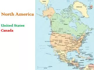
Physical Geography of North America – A Land of Contrasts. Landforms and Natural Resources. Landforms and Resources. U.S. and Canada are bound together by both physical geography and cultural heritage as well a s strong economic and political ties

E N D
Physical Geography of North America – A Land of Contrasts Landforms and Natural Resources
Landforms and Resources • U.S. and Canada are bound together by both physical geography and cultural heritage as well as strong economic and political ties • Both rank among the largest in the world • Both are rich in natural resources • Fertile soils, ample supplies of H20, vast forests and large deposits of a variety of minerals • Popular with immigrants from around the world
Varied Landforms Eastern Lowlands Appalachian Highlands • Flat, coastal plain along the narrower Atlantic coast from the Northeast to Florida • Offers many excellent harbors • Gulf Coastal Plain is much broader from Florida to Texas • Low plateau – called the Piedmont (rolling hills) – connects the lowlands to the mountains • Runs north to south from Alabama into Canada • Contain several other mountain ranges w/in (Catskill, Blue Ridge, Great Smoky Mountains)
Varied Landforms Interior Lowlands Mtn. Plateaus & Basins • Mainly level landsflattened by huge glaciers 1000’s of years ago • Includes lowland, rolling hills, thousands of lakes and rivers + some of the most fertile soil • Divided into 3 sub-regions: • Interior Plains – Appalanchains to 300 miles west of Mississippi • Great Plains – largely treeless area up to 4,000 ft. • Canadian Shield – rocky, mainly flat area covering 2 million sq. mi. • Rocky Mtns – Massive & rugged • Relatively young - 80 million years old – not eroded like Apps • Continental Divide – highest point of the Rockies that splits rivers flowing east and west • Sierra Nevadas & the Cascade Range run parallel to Pacific coastline • Highest peak is Mt. McKinley 20,320’ • Steep cliffs, deep canyons and lowland desert areas called basins
Varied Landforms The Islands Natural Resources • Canada’s northernmost lands are islands near the Arctic Circle • 3 islands – Ellesmere, Victoria & Baffin – are only smaller than Greenland • U.S. - Aleutian Islands - volcanic, rugged and treeless - off of Alaska and Hawaii – lush, tropical – both reside outside of continental U.S. • Oceans and Waterways • Atlantic, Pacific, Artic and Gulf of Mexico • Great Lakes – Superior, Michigan, Huron, Erie and Ontario • Lands and Forests • Minerals and Fossil Fuels • Gives U.S. & Canada means to industrialize • U.S. = world’s biggest consumer of energy resources • Canada’s exports to energy to U.S.