Download
1 / 41
410 likes | 539 Views
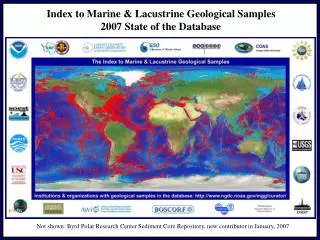
Index to Marine & Lacustrine Geological Samples 2007 State of the Database. Not shown: Byrd Polar Research Center Sediment Core Repository, new contributor in January, 2007. Index to Marine & Lacustrine Geological Samples September 2007 State of the Database. Samples Added to the Database

E N D
Index to Marine & Lacustrine Geological Samples2007 State of the Database Not shown: Byrd Polar Research Center Sediment Core Repository, new contributor in January, 2007
Index to Marine & Lacustrine Geological Samples September 2007 State of the Database Samples Added to the Database October 2004 – September 2007 INSTITUTION #SAMPLES NMNH 59,628 GSC/BIO 40,428* USGSWH 7,157 LDEO 905 USGSMP 599 OSU 501 BOSCORF 340 BPRC 270 URI 59 TOTAL 109,887 http://www.ngdc.noaa.gov/mgg/curator/updates.HTML * Complete redo of collection
Index to Marine & Lacustrine Geological Samples September 2007 State of the Database Data Processed & Under Review by Contributors INSTITUTION #SAMPLES ARF/FSU 1,714 LDEO 1,179 USGSMP 479 OSU 65 SIO 6 TOTAL 3,443 Data In Processing WHOI - entire collection update http://www.ngdc.noaa.gov/mgg/curator/updates.HTML
Index to Marine & Lacustrine Geological Samples September 2007 State of the Database Samples in review
Index to Marine & Lacustrine Geological Samples September 2007 State of the Database Total in Database: 170,430 samples (296,238 intervals) from 4,666 cruises
Index to Marine & Lacustrine Geological Samples September 2007 State of the Database 463,443 data records describing 170,430 sea floor & lakebed sampling locations(cores, grabs, dredges, drill holes)
Index to Marine & Lacustrine Geological Samples September 2007 State of the Database 2004 Suggestion: Create uniform web pages for active participants. • Facility supplies information • Directly launches facility layer in ArcIMS map • Sample location image generated live from database
Index to Marine & Lacustrine Geological Samples September 2007 State of the Database Database Specifications, Data Contributions, & Processing
Index to Marine & Lacustrine Geological Samples September 2007 State of the Database Facility Code NGDC Institution & Ship Codes Cruise Identifier Sample Identifier Date Sample Collected & Ending Date (dredges only) Latitude and Longitude Lat/Lon original type flag Ending Latitude/Longitude (dredges only) Water Depth Ending Water Depth (dredges only) Sampling Device Storage Method Core Length Core Diameter Depth to Top/Bottom of Interval Primary Lithologic Composition/Texture for Interval Secondary Lithologic Composition/Texture for Interval Other Components #1 through #6 Age of Interval Interval Number Bulk Weight Physiographic Province Rock Lithology Rock Mineralogy Rock Weathering & Metamorphism Rock Glass remarks & MN/Fe oxide coating Munsell Color code Principal Investigator Flag for material exhausted, no longer available Free-form lithologic description Comments on Interval Current database specifications: All fields are optional with the exception of institution, ship, cruise, sample, sampling device, and latitude/longitude. Complete FGDC/ISO metadata specification: http://www.ngdc.noaa.gov/nmmr/xmls/fgdc.jsp?id=gov.noaa.ngdc:G00028&view=classic More information and ternary diagrams/explanation: http://www.ngdc.noaa.gov/mgg/curator/curatorcoding.html
Index to Marine & Lacustrine Geological Samples September 2007 State of the Database Data Contribution and Review • Spreadsheets • Digital files in other forms • Review online • Iterative corrections, if necessary • Geospatially-enabled when approved Status: http://www.ngdc.noaa.gov/mgg/curator/updates.HTML
Index to Marine & Lacustrine Geological Samples September 2007 State of the Database Diversity of Sample Descriptions in the Database
Index to Marine & Lacustrine Geological Samples September 2007 State of the Database Sample Description Diversity Example of a minimal record from the database Minimum information for a sample to be included in the database: Ship, cruise, sample id, device, latitude, & longitude
Index to Marine & Lacustrine Geological Samples September 2007 State of the Database Sample Description Diversity Example of a fully-coded entry
Index to Marine & Lacustrine Geological Samples September 2007 State of the Database Sample Description Diversity Example of a detailed free-form descriptive entry
Index to Marine & Lacustrine Geological Samples September 2007 State of the Database Access to Sample Data in the Index
Index to Marine & Lacustrine Geological Samples September 2007 State of the Database The Oracle “Text” Interface to the Database In March 2007 the Curators’ Group approved A new Java Server Pages (JSP) replacement for the old PL/SQL text search
Index to Marine & Lacustrine Geological Samples September 2007 State of the Database JSP: Same features as the old interface
Index to Marine & Lacustrine Geological Samples September 2007 State of the Database
Index to Marine & Lacustrine Geological Samples September 2007 State of the Database JSP: Same features as the old interface
JSP: Slightly different look & feel from this point on New SESAR links
Index to Marine & Lacustrine Geological Samples September 2007 State of the Database External Links to Auxiliary Data, Graphics, and Reports
Index to Marine & Lacustrine Geological Samples September 2007 State of the Database Links to Data, Graphics, and Reports at NGDC
Index to Marine & Lacustrine Geological Samples September 2007 State of the Database Updates to the ArcIMS “Interactive Map” Interface & Addition of Web Services
Index to Marine & Lacustrine Geological Samples September 2007 State of the Database ArcIMS: New Capabilities
Index to Marine & Lacustrine Geological Samples September 2007 State of the Database Geospatially-enabled Database: New Capabilities • Shapefile extractions – not just for GIS applications
Index to Marine & Lacustrine Geological Samples September 2007 State of the Database Geospatially-enabled Database: New Capabilities • Web Map Service (WMS) http://map.ngdc.noaa.gov/wmsconnector/com.esri.wms.Esrimap? BBOX=-180,-90,180,90 &WIDTH=1024 &HEIGHT=512 &SRS=EPSG:4326 &Layers=emdark,odp,dsdp &version=1.1.1 &service=WMS &FORMAT=PNG &TRANSPARENT=TRUE &request=getmap &ServiceName=Sample_Index The same call, substituting: BBOX=-50,10,0,50 &WIDTH=512 &HEIGHT=256 &Layers=emdark,uri
Index to Marine & Lacustrine Geological Samples September 2007 State of the Database Geospatially-enabled Database: New Capabilities • Web Feature Service (WFS) http://map.ngdc.noaa.gov:80/wfsconnector/com.esri.wfs.Esrimap/Sample_Index_f?
Index to Marine & Lacustrine Geological Samples September 2007 State of the Database Reaching a broader audience: Representing the Index in other catalogs & systems • Google-search enhanced via web page design, metadata • Google-search enhanced via web page design, metadata • Metadata harvesting by widely-used systems (NASA/GCMD, GOS)
NOAA/NGDC Commitment to Sea Floor Data Stewardship Data Access Making data freely and publicly available. Data Rescue & Digitizing Rescuing data from scientists’ desks and file cabinets. Permanent Archive We’re in it for the Long Haul, Preserving data for your great-grandchildren
A partnership between NOAA and private industry to image and key paper and microfilm records and to make them available on the Web.
NOAA Climate Database Modernization Program (CDMP)_____________________________________ • CDMP Supports the Following Services: • Imaging from paper (sizes up to 42x60 inches), bound books, microfiche, microfilm, photographs, and negatives. • Keying from paper, microfiche, or digital images. • Optical Character Recognition (OCR). • Vectorizing. • Image indexing for on-line storage and retrieval.
NOAA Climate Data Modernization Program (CDMP) Digitization of Marine & Lacustrine Records of Climate Change Highlights of Project L-19: 2005 - 2007 Entire LDEO Core Photograph Collection Scanned/Available Online
NOAA Climate Data Modernization Program (CDMP) Digitization of Marine & Lacustrine Records of Climate Change Highlights of Project L-19: 2005 - 2007 Partial image – whole core online OSU, LacCore, and URI core logs were key-entered and archived in .PDF form
NOAA Climate Data Modernization Program (CDMP) Digitization of Marine & Lacustrine Records of Climate Change Highlights of Project L-19: 2005 - 2007 Most ARF/FSU Core X-rays Scanned/Available Online
NOAA Climate Data Modernization Program (CDMP) Digitization of Marine & Lacustrine Records of Climate Change Project L-19 Progress Summary: 2005 - 2007 • Scanning: • 31,825 core photographs/negatives (LDEO, OSU, LacCore, WHOI, SIO) • 7,234 core X-rays (ARF/FSU, OSU) • 1,043 coring data sheets (& 2,500+ non-CDMP) (OSU) • 5,069 sea floor photographs (ARF/FSU, LDEO) • Key-entry: • 6,202 core logs, smearslide descriptions, data sheets (OSU, LacCore, URI) Over $550K in NOAA funding Sample repository materials digitized 2005-August 2007. ~500 additional seabed photos will be scanned in 2007
NOAA Climate Data Modernization Program (CDMP) Digitization of Marine & Lacustrine Records of Climate Change Project L-19: 2008 Continuation • If your institution has materials to scan or key-enter for 2008, please contact NGDC with: • Volume estimates (#pages, photographs) • Samples (Xerox copy of typical description, photo copy) • Specifications, formats, resolution, etc.
NOAA/NGDC Commitment to Sea Floor Data Stewardship Data Access Making data freely and publicly available. Data Rescue & Digitizing Rescuing data from scientists’ desks and file cabinets. Permanent Archive We’re in it for the Long Haul, Preserving data for your great-grandchildren Did we mention that we provide a long-term archive for data from sea floor and lakebed samples at NGDC?
Why add your data to the NGDC archive? • NGDC’s mandate includes a commitment to provide access to, and long-term archival for data pertaining to sea floor and lakebed samples. • NGDC prepares and maintains documentation according to FGDC/ISO metadata standards. When metadata standards change, NGDC migrates metadata to new standards, maintaining its interoperability with other systems. • NGDC archives metadata with the data to increase their long-term utility. • NGDC data archives are maintained to NARA standards with offsite backups, storage on approved media, and periodic migration to new media and technologies. NGDC is finalizing an agreement with the LDEO Marine Geoscience Data System (MGDS) to permanently archive multibeam data from their system. Once finalized, NGDC hopes to extend the agreement to include sample data. We’re in it for the long haul, preserving data for your great-grandchildren.