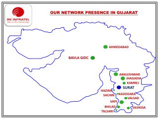
Download
1 / 10
100 likes | 227 Views
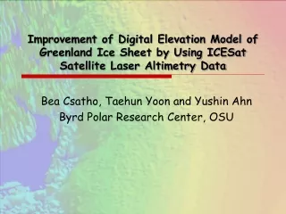
Improvement of Digital Elevation Model of Greenland Ice Sheet by Using ICESat Satellite Laser Altimetry Data. Bea Csatho, Taehun Yoon and Yushin Ahn Byrd Polar Research Center, OSU. Current Status and Objectives.

E N D
Improvement of Digital Elevation Model of Greenland Ice Sheet by Using ICESat Satellite Laser Altimetry Data Bea Csatho, Taehun Yoon and Yushin Ahn Byrd Polar Research Center, OSU
Current Status and Objectives Available DEMs of the Greenland Ice Sheet are based on satellite radar altimetry data (e.g., Bamber and Ekholm, 2001), or on the combination of radar altimetry data with AVHRR imagery by using photoclinometry techniques to fill the regions between radar orbits (Scambos and Harran). Here out referred to as ‘available DEM’ Elevation errors of these DEMs range from a few meters at the middle of the ice sheet (>2000 m) to 50-100m in marginal regions. Our objective is to improve the accuracy of these ‘Available DEMs’ by using ICESat data. The following example is shown for the boxed region, however a whole ice sheet DEM is currently being developed. ICESat Data to Improve Greenland DEMs
Input Data • 3/20/03- 6/23/05 ICESat satellite laser altimetry observations (L1, L2a-c, L3a-c) (L3d and L3e should be added) • Airborne Topographic Mapper (ATM) laser altimetry data from 1999-2003 (Krabill, NASA WFF) • ‘Available DEMs’ from Bamber et al. (2001) and Scambos and Harran • Landcover map of Greenland from KMS • Categories: ice sheet, local ice caps, land and ocean ICESat Data to Improve Greenland DEMs
Processing Steps Step 1: Detection and removal of outliers from the ICESat and ATM data sets. • Only points on ice sheet and local ice caps are used • ICESat outliers: elevations are compared with median elevation of 2 X 2 km grid cells. Points with elevation difference > 40 m from the median are removed. • ATM outliers are removed by using the same technique. In addition, all observations in cells with less than 2 data points are removed. Step 2: Residuals between the ICESat data and the ‘Available DEM' are computed at each ICESat point over the ice sheet and local ice caps. Residuals are set zero at grid posts over land and ocean Step 3: Residuals are interpolated into a regular grid by using minimum curvature interpolation. ICESat Data to Improve Greenland DEMs
Processing Steps cont. Step 4: Improved DEM = ‘Available DEM’ + interpolated residual Step 5: The accuracy of the improved DEM is assessed by using the ICESS data set (compressed ATM airborne laser scanning data derived by plane fitting to original laser point swaths) ICESat Data to Improve Greenland DEMs
Distribution of Data Points ICESat (red) and ATM (blue) ICESat Data to Improve Greenland DEMs
‘Available DEM’ (Upper Panel) + Interpolated ICESat Residual (Lower) = Merged DEM using ICESat Data and Available DEM ICESat Data to Improve Greenland DEMs
Close Up Comparison of DEM’s Available DEM Improved DEM ICESat Data to Improve Greenland DEMs
Error Assessment: ATM – DEM Elevations ATM elevations - photoclinometry DEM Dh= -4.63 m +/- 45.06 m ATM elevations – new DEM Dh= -0.12 m +/- 31.84 m ICESat Data to Improve Greenland DEMs
NEW “AND IMPROVED” SHADED RELIEF MAP Thank you ICESat Data to Improve Greenland DEMs