Download
1 / 2
20 likes | 182 Views
WATER. W ater A vailability T ool for E nvironmental R esources.

E N D
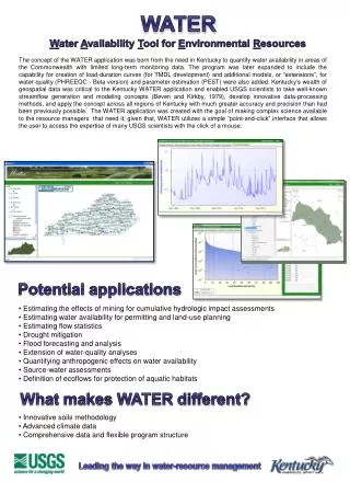
WATER Water Availability Tool for Environmental Resources The concept of the WATER application was born from the need in Kentucky to quantify water availability in areas of the Commonwealth with limited long-term monitoring data. The program was later expanded to include the capability for creation of load-duration curves (for TMDL development) and additional models, or “extensions”, for water-quality (PHREEQC - Beta version) and parameter estimation (PEST) were also added. Kentucky’s wealth of geospatial data was critical to the Kentucky WATER application and enabled USGS scientists to take well-known streamflow generation and modeling concepts (Beven and Kirkby, 1979), develop innovative data-processing methods, and apply the concept across all regions of Kentucky with much greater accuracy and precision than had been previously possible. The WATER application was created with the goal of making complex science available to the resource managers that need it; given that, WATER utilizes a simple “point-and-click” interface that allows the user to access the expertise of many USGS scientists with the click of a mouse. Potential applications • Estimating the effects of mining for cumulative hydrologic impact assessments • Estimating water availability for permitting and land-use planning • Estimating flow statistics • Drought mitigation • Flood forecasting and analysis • Extension of water-quality analyses • Quantifying anthropogenic effects on water availability • Source-water assessments • Definition of ecoflows for protection of aquatic habitats What makes WATER different? • Innovative soils methodology • Advanced climate data • Comprehensive data and flexible program structure Leading the way in water-resource management
Applications in Local and National science National USGS efforts: Developing estimates of runoff-contributing areas used in National-scale models (SPARROW) and assessing of the effects of global climate change; including the Great Lakes Restoration Initiative (Screen Capture of WATER application for Lake Michigan region below). WATER- and TOPMODEL-based example applications by state: Kentucky: Assessing local and regional water availability, assessing ecosystems, and as a component of a “Stream Condition Index” tool. Alabama: Estimating water availability in Alabama with focus on daily mean flows at the spatial scale of 12-digit HUCs. Florida: Assessing ecosystem flows. Coarse and fine resolution hydrologic models are being coupled with biological models to estimate the effects of changing water availability on fish populations at a stream reach level. Georgia: Estimating ecologically-relevant flow metrics for input to a model of fish-species occurrence and distribution. Hydrologic, geologic, geomorphic, water-quality, and landscape characteristics are being used in the model to assign species-presence probabilities to fish communities. Kansas: Developing estimates of potential runoff-contributing areas in Kansas to assess water-quality and other issues. New Jersey: Quantifying water-availability, effects of digital elevation models (DEM) resolution on landscape characteristics, relations between terrain characteristics and stream chemistry, and the effects of climate change on water resources. New York: Developing models for mercury in streams and rivers in an on-going joint effort with USGS National Water Quality Assessment (NAWQA) program and EPA. South Carolina: Assessing the hydrologic controls on the transport of mercury species between uplands/hill slopes, riparian wetlands, and stream channels. WATER- and PHREEQC-based applications (Beta version within WATER completed): Speciation Modeling: Speciation modeling is useful in situations where the possibility of mineral dissolution or precipitation needs to be known, as in water treatment, aquifer storage and recovery, artificial recharge, and well injection. Batch-Reaction Modeling: Batch-reaction modeling can be applied to problems in laboratory, natural, or contaminated systems. The reaction capabilities of PHREEQC have been used frequently in the study of mine drainage, radioactive-waste disposal, degradation of organic matter, and microbially mediated reactions. Transport Modeling: The reactive transport capabilities can be used to study contaminant migration of nutrients, metals, radionuclides, and organic compounds; natural and engineered aquifer remediation; diffusion in sediment pore water; the chemical evolution of natural systems; and laboratory column experiments. For more information on PHREEQC see: http://wwwbrr.cr.usgs.gov/projects/GWC_coupled/phreeqc/ Additional Information and Contacts Pete Cinotto Bill Caldwell USGS Kentucky Division of Water 9818 Bluegrass Parkway 200 Fair Oaks Lane , Fourth Floor Louisville, KY 40299 Frankfort, KY 40601 502-493-1930 502-564-3410 Email: pcinotto@usgs.gov E-mail: water@ky.gov Visit us on the web! http://ky.water.usgs.gov/projects/waterbudget/index.html