Download
1 / 27
280 likes | 430 Views
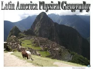
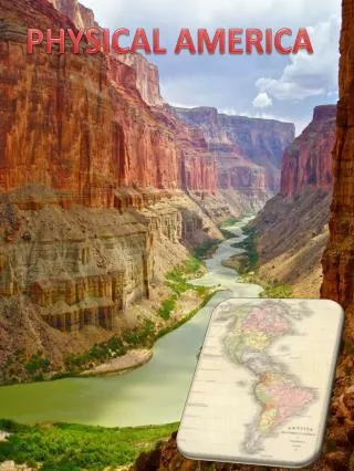
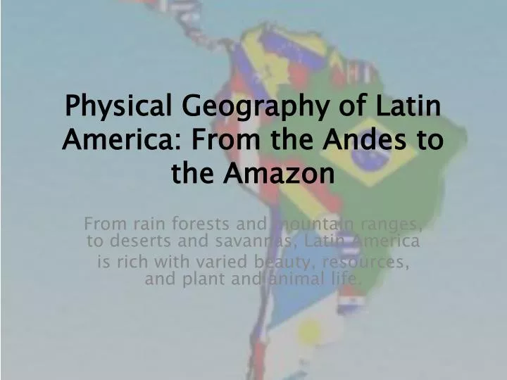
Physical Geography of Latin America: From the Andes to the Amazon. From rain forests and mountain ranges, to deserts and savannas, Latin America is rich with varied beauty, resources, and plant and animal life. Section 1: Landforms and Resources Section 2: Climate and Vegetation

E N D
Physical Geography of Latin America: From the Andes to the Amazon From rain forests and mountain ranges, to deserts and savannas, Latin America is rich with varied beauty, resources, and plant and animal life.
Section 1: Landforms and Resources • Section 2: Climate and Vegetation • Section 3: Human-Environment Interaction
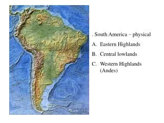
Section 1: Landforms and Resources • Latin America’s landforms include highlands, lowlands, mountains, and plains. • The Andes Mountains and the Amazon River are the region’s most remarkable physical features.
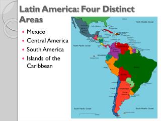
Section 1: Landforms and Resources Mountains and Highlands An Enormous Span • Latin America spans 7,000 miles - from U.S.-Mexicoborderto Tierra del Fuego, themostsoutherntip of South America. • Covers part of North America, all of Central and South America, and Caribbean Islands - Features highlands, lowlands, rain forests, and plains, which are all bounded by the Atlantic and Pacific. The Andes Mountains • Andes Mountains—South American range along western side of continent - part of chain that includes Rockies in U.S., Sierra Madre in Mexico - barrier to interior of the continent and has forced settlement along eastern and northern coasts - It was once home to Inca civilization in Peru; it also has many active volcanoes
Continued Mountains and Highlands Highlands • Highlands—mountainous or hilly areas of country Other ranges include: - Guiana Highlands are in northeast section of South America - Brazilian Highlands are located along east coast of Brazil - highlands cover parts of Venezuela, Guyana, Suriname, French Guiana
Plains for Grain and Livestock South America has wide plains that offer rich soil for growing crops Llanos of Colombia and Venezuela • Llanos—grassy, treeless areas used for livestock grazing, farming - similar to Great Plains of U.S. or pampas of Argentina Plains of Amazon River Basin • Cerrado—flat savannas with moderate rainfall, good for farming - found in interior of Brazil, mostly undeveloped Pampas of Argentina and Uruguay • Pampas—areas of grassland, rich soil, used for cattle and wheat - home to gaucho culture centered on horsemen
Continued The Amazon and Other Rivers Amazon River • Amazon River—flows 4,000 miles, from west to east, to Atlantic - branches start in Andes - fed by over 1,000 tributaries - carries more water than next seven largest rivers combined
The Amazon and Other Rivers Central American Rivers • Central America, Caribbean: bordered by water, fewer river systems - North America’s Rio Grande forms border between U.S. and Mexico • less dependent on rivers for transportation than South America • Has 3 major river systems Orinoco, Amazon, Parana. Orinoco River • Orinoco River—1,500 miles through northern South America to Atlantic - flows partly along Venezuela-Colombia border, drains interior lands - home to continent’s few remaining native peoples
Continued The Amazon and Other Rivers Paraná River • Paraná River—3,000 miles, starts in Brazilian highlands - flows south and west through Paraguay, Argentina, turns eastward - between Argentina and Uruguay becomes estuary Rio de la Plata • Estuary—wide lower course of river where its current is met by tides
Major Islands of the Caribbean Columbus and the West Indies • West Indies: Bahamas, Greater Antilles, Lesser Antilles - site of Columbus’ landing; later Spanish base for mainland conquest Bahamas • Hundreds of islands off southern Florida, north of Cuba - Nassau is largest city and capital
Continued Major Islands of the Caribbean The Greater Antilles • Largerislands in Caribbean: Cuba, Jamaica, Hispaniola, Puerto Rico - Hispaniola divided between Haiti, Dominican Republic The Lesser Antilles • Smaller islands southeast of Puerto Rico - Windward Islands face winds that blow across them - Leeward Islands are sheltered from prevailing northeasterlies
Resources of Latin America A Treasure House • Region is rich with minerals, energy resources, agriculture, forests Mineral Resources • Gold, silver, iron, copper, bauxite (aluminum ore), lead, nickel - also precious gems, tin, titanium, tungsten • South America is a world leader in mining, exporting raw materials - Example: Jamaica used to be plantation economy (bananas, sugar) - began bauxite mining to reduce dependency on agriculture, tourism
Continued Resources of Latin America Energy Resources • Oil, coal, natural gas, uranium, hydroelectric power are plentiful - Brazil rich in hydroelectric power (from rivers, waterfalls), oil, gas - Trinidad has natural gas; major exporter of methanol, ammonia - Venezuela, Mexico have major oil deposits, export oil to world
Section 2: Climate and Vegetation • Latin America has a variety of climates, from the cold peaks of the Andes to the Amazon rain forest. • The vegetation of Latin America ranges from grasslands to the largest rainforest in the world.
Section 2: Climate and Vegetation A Varied Climate and Vegetation Reasons for the Variety • Latin America’s broad range of climate, vegetation due to 3 factors: - it spans great distances on either side of the equator - it has big changes in elevation due to the mountains - its climate’s affected by both warm Atlantic currents and cold Pacific currents
Tropical Climate Zones Tropical Wet • Rain forests—dense forests with different species of trees - hot and rainy all year - This climate forms an unique ecosystem—community of plants, animals living in balance • Largest is Brazil’s Amazon rain forest with 2 million square miles - 2,500 types of Amazon trees - animals include anaconda, jaguar, piranha
Continued Tropical Climate Zones Tropical Wet and Dry • Savannas found in South America: Brazil, Colombia, Argentina - hot with seasonal rain
Dry Climate Zones Semiarid • Dry climate with some rain - home to vast, grass-covered plains or desert shrubs - found in Mexico, Brazil, Uruguay, Argentina Desert • Found in north Mexico, coast of Peru, north Chile’s Atacama Desert - parts of Argentina’s southern Patagonia are desert • Vegetation is mostly shrubs growing in gravel or sand
Mid-Latitude Climate Zones Humid Subtropical • Rainy winters and hot, humid summers; varied vegetation - parts of Paraguay, Uruguay, south Brazil and Bolivia, north Argentina Mediterranean • Hot, dry summers and cool, moist winters - vegetation is chaparral (drought-resistant trees) - this is the climate of part of Chile along the west coast - climate similar to that of California
Continued Mid-Latitude Climate Zones Marine West Coast • Cool, rainy winters and mild, rainy summers; forest vegetation - occurs in southern Chile and Argentina - similar to the climate of Oregon or Washington Highlands • Varies from moderate to cold due to elevation, wind, sun, landscape - found in mountains of Mexico and South America
Section 3: Human-Environment Interaction • The people of Latin America have altered the land through agriculture and urbanization. • Tourism is having a growing impact on the environment of Latin America.
Section 3: Human-Environment Interaction Agriculture Reshapes the Environment Slash-and-Burn • One way ag has affected the environment is: Slash-and-burn— cut trees, brush, grass; burn debris to clear fields - used by native peoples and today by poor farmers in Amazon basin - they move to new area when soil is exhausted - This is one reason for shrinking rain forests Terraced Farming • Terraced farming—step-like farm fields cut into mountains, hillsides - lets crops grow on steep land, cuts down on soil erosion - used by Incas in Peru, Aztecs in Mexico
Urbanization: The Move to the Cities From Country to City • Highly urbanized countries: Argentina, Chile, Uruguay, Brazil. 85% of people live in cities here. • Subsistence farming barely supports people and their families - they move to cities to improve their lives. There are Push/Pull Factors for such a large city population. • Push factors—factors that “push” people to leave rural areas - poor medical care, poor education, bad jobs, only rich few own land • Pull factors—factors that “pull” people to cities - better jobs, schools, medical care
Continued Urbanization: The Move to the Cities Rapidly Growing Cities • Six of Latin America’s most populous cities are in South America • Sao Paulo and Rio de Janeiro, Brazil • Lima, Peru • Buenos Aires, Argentina; • Bogota, Colombia; • Santiago, Chile • Most populous city in Latin America is Mexico City - 18 to 20 million in city, 30 million in greater metropolitan area
Continued Urbanization: The Move to the Cities Rapidly Growing Cities • Similar problems affect cities throughout region - growing slums - increasing unemployment and crime - environmental problems include air pollution, drinking water shortages • Governments can’t afford facilities to support population increases - failing infrastructure—sewers, transportation, electricity, housing
Tourism: Positive and Negative Impacts Tourism plays a large part in Latin America Advantages of Tourism • Tourists spend money on souvenirs, trips, restaurants - new hotels, businesses have been built in Mexico and the Caribbean - regional ports serve cruise ships - residents work in restaurants and resorts, guide tours and activities • All of this helps reduce the income gap between rich and poor.
Continued Tourism: Positive and Negative Impacts Disadvantages of Tourism • Resorts built in unspoiled settings create congestion and pollution • Gap between rich tourists and poor residents creates resentment • Local governments run up debt to build tourist facilities, such as: - airports, harbors, hotels, resorts, sewage systems, shopping malls • Facility owners often live out of country, so profits leave the area - A problem because these owners make decisions that may not be in area’s best interest