Download
1 / 39
400 likes | 592 Views
Chapter 2 The Flow of Fresh Water. Section1 The Active River. Rivers: Agents of Erosion. Six Million Years ago the Grand Canyon was as flat as Pitt County farm land. The Colorado River has worn down through the river bed a distance of over 1 mile.

E N D
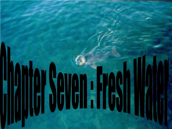
Chapter 2The Flow of Fresh Water Section1 The Active River
Rivers: Agents of Erosion • Six Million Years ago the Grand Canyon was as flat as Pitt County farm land. • The Colorado River has worn down through the river bed a distance of over 1 mile. • Erosionis the process by which soil and sediment are transported from one location to another.
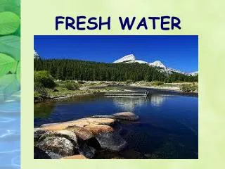
The Water Cycle • Thewater cycleis the continuous movement of Earth’s water from the ocean to the atmosphere to the land and back to the ocean
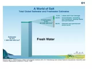
0.7 is All!!! • Out of all the water on Earth, only 2.75 percent is fresh water, including 2.05 percent frozen in glaciers, 0.68 percent as groundwater and 0.0001 percent of it as surface water in lakes and rivers.
River Systems • River System – the network of creeks and streams that join to form rivers • These river systems drain a land area of its run off water • Tributary – a creek or stream that drains into a lake or larger stream • In North Carolina, rivers run down from mountains in the west and drain/run east until emptying into the Atlantic Ocean
Watersheds • Watershed – the drainage basin of a river system • The area of land that is drained by a river system • Greenville, Tarboro, and Washington are in the Tar River/Pamlico River watershed • Raleigh, Kinston and New Bern are in the Neuse River watershed. • Divide – high ground that divides watersheds; example: Continental Divide
Stream Erosion • As a stream forms, it erodes soil and rock to make a channel • A stream’s ability to erode is influence by three factors: gradient, discharge, and load. • Gradient is the measure of the change in elevation over a certain distance. A high gradient gives a stream or river more energy to erode rock and soil
Gradients Low Gradient Less/Slower Erosion Less Energy High Gradient More/Faster Erosion More Energy
Stream Erosion (cont.) • Dischargeis the amount of water that a stream or river carries in a given amount of time. As discharge increases, erosive energy and speed also increase. • Large storms/Snow melt cause increase • Loadis the materials carried by a stream. The size of a stream’s load affects its rate of erosion • Fast moving water can move large particles • Rocks in mountain streams • Sand at the ocean
3 Kinds of River Loads • Bed Load – large materials, such as rocks and boulders, that are bounced along a stream bed • Suspended Load – small rocks and soil carried suspended in the water column; gives river its muddy look • Dissolved Load – material carried in solution; dissolved in the water such as calcium, sodium and oxygen
How Rivers Change Over Time • Young Rivers – narrow, straight & deep channel, steep gradient, more erosion; many rapids and waterfalls, few tributaries • Mature Rivers – wide channel, lower gradient, less mass erosion, more tributaries = more water discharge
How Rivers Change Over Time • Old Rivers – wide, flat flood plains; many curves or bends in the channel, deposit silt and sand along banks • Rejuvenated Rivers - result of tectonic (earth moving) activity • steep gradient again, forms terraces • Terraces - step like formations; like Grand Canyon
Chapter 2The Flow of Fresh Water Section 2 Stream and River Deposits
Deposition in Water • Deposition – the process of rivers dropping their suspended load of rocks and soil. • Sediment – the rocks, sand, pebbles and silt that is deposited by a river as its waters slow down Rocks PebblesSand Silt Fast Water Slow Water
Deposition in water (cont.) • Placer Deposits – where a river slows in a curve it can deposit heavy minerals like • Delta – fan shaped deposit where a river empties into a large body of water like an ocean or large lake • Deposits cause new land to be formed • Eventually very fertile soil Gold
Satellite Photo - Nile River Delta Land build-up with fertile soil showing green plants
Deposition on Land • Alluvial Fan - a fan shaped delta-like deposit formed at the base of a mountain
Deposition on Land (cont.) • Floodplain – the Pitt-Greenville airport and the land north of the river is on the floodplain for the Tar River. • That’s why that land flooded so badly during Hurricane Floyd
Flood Control • Dam – Across a river to stop or divert water flow Levee – sediment built up along a river channel to keep river in its banks
Chapter 2The Flow of Fresh Water Section 3 Underground Water
Location of Groundwater • Water located within the rocks below the Earth’s surface is called groundwater Zone of Aeration – spaces between soil & rocks is filled with air Water Table - Dynamic (changing) boundary between zones Zone of Saturation – spaces between soil and rocks is filled with water
Aquifers • A rock layer that stores and allows the flow of groundwater. Affected by… • 1. Porosity - the % of open space between particles • 2. Permeability – the amount of H2O that can pass through • Impermeable – cannot penetrate
Springs & Wells • Natural Spring – where the water table meets the surface of the Earth • Lake - when the water table is higher than the earth’s surface for a large area
Artesian Springs • Artesian formation - permeable rock sandwiched between 2 layers impermeable rock • Middle permeable rock = aquifer • top layer = cap rock • Artesian spring – when cap rock breaks or cracks at Earth’s surface • Geothermal (earth heat) heated water = hot spring • “Old Faithful” Geyser
Well • Human drilling in Earth’s surface down to water table. • If water is drawn out too much or too quickly = cone of depression
Underground Erosion and Deposition • Underground water, especially acidic water, can dissolve underground rock resulting in sinkholes or caves • Limestone rock is easily dissolved because it is relatively soft • In caves, form stalactites and stalagites • If meet in the middle = dripstone column
Chapter 2The Flow of Fresh Water Section 4 Using Water Wisely
Water Pollution • Point Source Pollution – you can point to the source • Nonpoint Source Pollution – most by runoff – fertilizers, waste runoff, cattle farms, etc.
Health of a Water System • Dissolved Oxygen – fish kills • Temperature – too hot, low D.O. • Nitrates – Weyerhauser (Neuse) • Phosphates – Texas Gulf Mining (Pamlico) • pH - acidic • Turbidity – sediment, too much algae • Biological Indictors – algae, fish kills
Monitoring Water Quality Ground Truthing – Taking samples on the ground to check with satellite images
Cleaning Polluted Water • Sewage Treatment Plants – clean waste out of water • Primary Treatment • 1. Large screen to catch solids, paper, bottle caps, etc. Add chemicals to make it clump together • 2. Placed in large tank for smaller sludge can settle out. Oils and scum skimmed off of surface. • Secondary Treatment • 1. Aeration Tank where H2O & bacteria are added • 2. Settling Tank where particles settle out & Chlorine is added
Where Water Comes From: • More than ½ of NC depend on water from Aquifers • Wherethe water goes: • The average household uses 100 gallons of fresh water per day
Water in Agriculture: • Most lost through evaporation and runoff • Ground level drip hoses – a lot more efficient • Water in Industry: • 19% of world’s water used for industry • Most industrial water is now recycled • Water at Home: • Conservation - Low-flow Shower Heads • Wash only full loads of clothes • Plant Native plants to avoid having to water • (Native-naturally found in that area)