Download
1 / 15
350 likes | 1.21k Views
Google Earth, Google Maps, and Street View. By Edwin Partovi and Katerina Efimova Fall, 2008.

E N D
Google Earth, Google Maps, and Street View By Edwin Partovi and Katerina Efimova Fall, 2008
"... It is amazing demo and a great example of how much power computers and the internet have put into the hands of average people. You may not use Google Earth every day, but it's worth fooling around with just because it's cool." Walt Mossberg, The Wall Street Journal
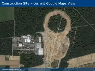
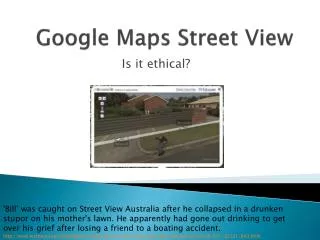
Google Earth displays satellite images of varying resolution of the Earth's surface, allowing users to visually see things like houses and cars from a bird's eye view.
Global Positioning System • GPS was developed by the US Department of Defense to provide navigation services for the military. • It has since become an integral asset in various industries and applications, such as for recreation, surveying, and vehicle tracking. • GPS employs 24 spacecrafts in 24,000 km orbit to triangulate positions on earth to a potential accuracy of 20 m.
NASA’s “Satellite Tracking” • NASA has implemented a series of programs that allow users to locate satellites, including the Hubble Space Telescope, the International Space Station, and space shuttles. • Users can also predict landing tracks for recent or upcoming shuttle flights.
Comparisons with Mapquest, Ask Maps, Windows Live Local, and Yahoo! Maps • As of 2006, Google Earth is not the most popular service, with about 20 million unique visitors as opposed to Yahoo’s roughly 46 million. • Google Maps excels in the services of view, zoom, user interface and features (including multi-point directions, live traffic information, and cell phone service), but Yahoo! is a close second.
False-Color • A false-color image is an image that depicts a subject in colors that differ from those the human eye would perceive in reality, referred to as true-color. • For example, a photographic negative depicts the complementary colors of its subject, but the image itself is obvious. • In much the same way, digital image processing, used by Google Maps, depicts ultraviolet and infrared radiation and altitude with visible colors.
QuickBird • QuickBird is a high-resolution commercial earth observation satellite, owned by DigitalGlobe and launched in 2001. • It collects the second highest resolution imagery of earth, but boasts the largest image size and the greatest on-board capacity. • QuickBird is the image digital supplier for Google Maps, providing the backdrop for such mapping aplications.
GlobeXplorer • GlobeXplorer is an online special data company that compiles and distributes aerial photos, satellite imagery, and map data from their online spatial archives. • It has been credited as the first company to establish a business around compiling and distributing online aerial and satellite imagery. • It provides these images to mapping services such as Google Maps.
Google Maps for Mobile & GPS • iPhone/iPod Touch • Windows Mobile • Nokia/Symbian (S60 3rd edition only) • Symbian OS (UIQ v3) • BlackBerry • Phones with Java-Platform (MIDP 2.0 and up), for example the Sony Ericsson K800i • Palm OS (Centro and newer)